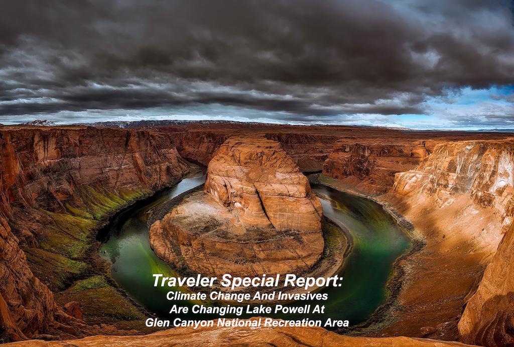
Image by David Mark from Pixabay
Editor's note: A warming climate has been linked to human activity around the world, and has affected the Colorado River System as well. The impacts are substantial, from reduced water flows, threats to indigenous species and the influx of new invasive species along the river system. National Parks Traveler sent Patrick Cone to investigate the impacts of climate change on Canyonlands National Park and Glen Canyon National Recreation area. This is the final installment of the series.
Not Enough Water And Too Many Invasives At Glen Canyon National Recreation Area
By Patrick Cone
Water is big business, bigger in the Southwest than perhaps anywhere else in the United States, and so where the Colorado River flows, economics and politics closely follow. More than 40 million people downstream depend upon its waters for agriculture, cities and businesses. At Glen Canyon National Recreation Area in southern Utah and northern Arizona, that reality rises in the 710-foot tall Glen Canyon Dam and shimmers in the reservoir that it has formed, Lake Powell.
But years of drought, upstream diversions and impoundments, and an overly optimistic forecast of Colorado River flows, have sapped the river once literally called Grand. Invasions of non-native species, and growing crowds of visitors, are contributing to the insults the river has struggled to bear, insults that only figure to worsen as climate change continues to squeeze the river from its headwaters in Rocky Mountain National Park down to the Gulf of California.
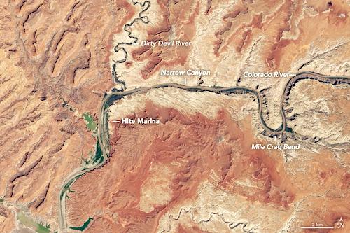
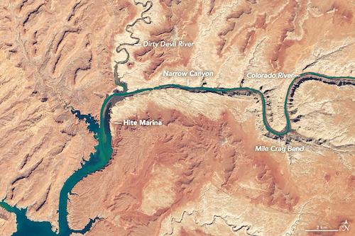
Lake Powell today holds barely half of what it was designed for, and downstream, Lake Mead is less than 40 percent full. Glen Canyon National Recreation Area’s future as storehouse for water, and a summer place to play, are threatened. It’s a conundrum for the two federal agencies — the U.S. Bureau of Reclamation (BOR) and National Park Service (NPS) — that manage these two lakes with two decidedly differing missions.
"Recreation is an important benefit, but it’s a side-benefit,” says Marlon Duke, a spokesman for the Bureau of Reclamation that operates the dams on Lake Powell and Lake Mead. But the primary purpose of the dam, part of the Colorado River Storage Project (CRSP), is not recreation or even hydroelectric power. “The primary purpose of the dam,” he says, “is to store water and hold it.”
The National Park Service, however, is responsible for preserving and protecting the natural and cultural resources, unimpaired, for future generations, but has no authority on the management of the dam, or water levels in the lake and river. With few tools to battle climate change, the NPS is studying the changes that have already occurred, while planning for a different climate and future.
The data is in, the science has been done, and the results of global climate change are very evident along the Colorado River, and specifically at Lake Powell. Dozens of studies by hundreds of scientists and many published reports attest to the fact that the climate is definitely becoming warmer, and drier, at Lake Powell. Less water and higher temperatures are threatening the animals, plants, and, in fact, the entire ecosystem. And, it’s going to get a lot worse, researchers say.
The numbers don’t lie. Climate scientist Brad Udall writes of the Colorado River, “Between 2000 and 2014 annual river flows averaged 19% below the 1906-1999 average. It’s the worst 15-year drought on record. One-third of flow loss is due to high temperatures.” By his calculations, river flows will be reduced by 20 percent mid-century, and 35 percent less at the end of the century. Meanwhile, temperatures have risen nearly one degree Celsius from 2000 through 2014. That’s a big change in a short amount of time.
But what can be done to mitigate this diminishing resource, which provides water to so many people? What sort of climatic conditions will we see in the future on the Colorado Plateau? How can we predict these changes and react to them? How will this warmer and drier climate affect the entire environment and ecosystem, the animals and plants that live there?
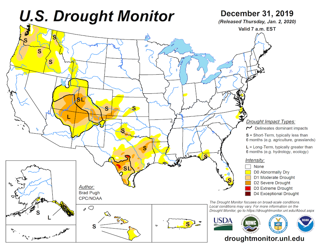
The Southwest has been locked in a long-term drought/NOAA
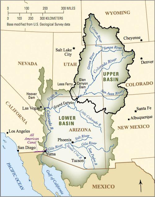
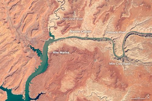
Glen Canyon Dam was put into service in 1964, creating Lake Powell and changing the river ecosystem forever, both above and below the dam. Lake Powell is the second-largest reservoir in the United States, next to Lake Mead downstream. The concrete, double-arch dam is sandwiched between the narrow canyon walls of Navajo sandstone, and the lake took 18 years to fill. It covers more than 1.25 million acres when at full pool. The Colorado River feeds the lake from its headwaters in the Rocky Mountains of Colorado, and takes in what the Green (which flows out of the Wind River Range in Wyoming), San Juan, Dirty Devil, and Escalante rivers will give it.
Contributing to the stress on the Colorado River are 15 large dams on the river’s main stem; all are part of the massive CRSP, created in the 20th Century. The river water supports a $5 billion agricultural industry along its 1,450 miles, with 80 percent of the water dedicated to crops. Just 10 percent goes to downstream cities.
In 1922, 15 million acre-feet of Colorado River water was divided equally by the Colorado River Compact into a Lower Basin and Upper Basin, whose border is 15 miles downstream of the Glen Canyon Dam at Lees Ferry. But that was 1.2 million acre-feet over the apportionment.
When Colorado River flows were calculated during the 1950s, it was based on just 18 years of streamflow measurements. But now scientists realize how optimistic these numbers were. During planning for the Glen Canyon Dam, Raymond Hill, a hydrologic engineer for the BOR, said that there was 6 million acre-feet less water.
“The discharge of the Colorado River at Lees Ferry has averaged only 11.7 million acre-feet since 1930,” he said.
Randy Riter with the BOR concurred in 1965, when he said, “There is not enough water in the Colorado River to permit the Upper Basin to fully use its apportionment of 7.5 million acre-feet and still meet compact obligations to deliver water at Lees Ferry.”
So, there is less water to go around, and a changing climate means even drier conditions. That’s what managers are up against now.
“We operate Glen Canyon and Hoover Dam at Lake Mead, and operate those two reservoirs together,” says BuRec’s Duke. “We balance the contents of the reservoirs. We operate based upon the hydrology we see, and then we use those models to determine how to operate in a given year.”
But right now, that means trouble. “We’re 19 years into the one of the worst droughts in recorded history,” adds Duke. “We’ve gotten 19 years into this drought, but we can’t just continue the status quo. We have to take major steps to protect the water supply.”
There has not been a big shortage declaration either for the 40 million users downstream, but that could change. And that is why the Compact and is now being renegotiated.
Dr. Jack Schmidt is professor of Watershed Sciences at Utah State University, and heads the Center for Colorado River Studies. Politics, he says, are making negotiations over the Compact difficult.
“The political agreement is about how to share the pain of drought. The renegotiation of that pain is supposed to begin sometime in 2020, and has to be concluded by 2025. The game that is played is that we have a hierarchy of treaties, laws, compacts, and rules, collectively called the Law of the River,” he explains. “The treaty we work off of is the 1944 treaty. We have changed the treaty 300 plus times. It’s called the Interim Shortage Guidelines negotiated in 2007. Those pending negotiations will carry the fate of Glen Canyon National Recreation Area, and reservoir recreation is going to be the furthest thing from anyone’s mind… It’s pretty much an irrelevancy.”
There are plenty of climate models being developed to predict water supplies in the future. The Colorado River Simulation System (CRSS) looks at 12 reservoirs and 29 headwater tributaries, and is used by the BOR and other stakeholders. There’s the aforementioned 2007 Colorado River Interim Guidelines for Lower Basin Shortages and coordinated operations for Lake Powell and Lake Mead, the 2012 Colorado River Basin Water Supply and Demand Study and the 2015 Glen Canyon Dam Long-Term Experimental and Management Plan.
Models developed by James Prairie, a hydrologic engineer for the Bureau of Reclamation, look out in the near term, from 1-2 years, the mid-term, from 1-5 years, and long term, from 1 to 50 years in the future, utilizing historic data and paleo information going back thousands of years. “But,” he says, “none of us know what dataset is right for the future.”
Figuring out how to operate two large dams under these conditions, BuRec's Duke says, is a monumental challenge, just as building the Glen Canyon Dam was.
“Modelers are looking at historic hydrology, looking at future forecasts, at likelihoods of how the climate is going to change. (This data) is plugged into the models and kicks out a likelihood of certain river flows. It’s a 24-month study, and that’s kind of short, but it’s really difficult to forecast accurately next week, let alone two years or five years down the road. It tells us what the model thinks is going to happen as far as inflows into the reservoirs, but we update that every month.”
Dr. Schmidt is not very optimistic.
“The thing that we know is that the climate is warming. There is a strong correlation between a warming climate and decreased runoff in the Colorado River,” he said. “What we know is that there will be an ever-decreasing amount of water flowing into Lake Powell from the Colorado River, the Green River and from the San Juan River. We also know it will be highly variable, there will be more drought years than big water years. Every once in a while, it’ll be a big winter. They will be fewer, but they will still come.
“The most important point is that the fate of the reservoir is contingent partly on climate change, and partly to society’s response to climate change,” he went on. “The thing we are trying to understand with Powell and climate change, if it is the case that there is not enough runoff to sustain both reservoirs, and it’s inevitable that Powell will get really warm, then are we are on a fool’s errand to be trying to manage Grand Canyon to be a cold place, when it fact it’s impossible to maintain forever.
"Perhaps we are better off to robustly anticipate the future but when Powell gets really low, it’ll get really different. So, we better develop a new ecosystem plan. But what happens to Lake Powell is not only about decreasing runoff, it’s about how society makes decisions about what to do with that water.”
Schmidt has proposed letting Lake Mead fill first, with Lake Powell as a backup pool.
“So, what do you do when you have less runoff in the system? You could preferentially store your water, though less water, in Lake Powell. Therefore, Lake Powell would be full,” he explained. “Or you could store it in Lake Mead and Lake Powell would be empty most of the time. Now we keep the contents of Powell and Mead approximately equal, and they both go up and down. You have the two of the largest reservoirs in the United States, and operate them as one. The political decision is that we keep them both half full.”
But what comes next, and what impact will it have on the river, the canyons, the environment and the species that live there?
Scott Vanderkooi is the chief of the Grand Canyon Monitoring and Research Center for the USGS in Flagstaff, Arizona, and is seeing rising water temperatures.
“Changes have been really rapid. We’ve had a long-term drought in the Southwest, since 2000. There’s a lot less water coming into the reservoirs, particularly Lake Powell, and that’s affected water quality released from the dam,” he said. “Previously when the reservoir was full the temperatures would peak at 10 to 11 degrees Celsius (around 50 degrees Fahrenheit). This year dam releases peaked at 16 degrees Celsius. Water temperatures control all biological processes in rivers. It’s the new abnormal, not just a 20-year drought. It has huge consequence on ecosystem and the creatures that depend upon them.”
Long-time Page, Arizona, resident Ada Hatch has certainly seen the change in climate during her 51 years teaching school there. “Of course, the climate is definitely getting warmer. When I first got here, we had snow in the winter. Now if we get snow it only lasts three or four hours and it’s gone. For sure it’s drier, and definitely the climate is warming up.”
And summer monsoons during the summer of 2019 were nearly nonexistent. “That moisture is very important to Arizona, New Mexico, the Grand Canyon and Utah,” observes John Weisheit, the Colorado River Keeper, one of 300 in the Living Rivers network globally. “It’s important to our highlands and high deserts. And that’s going away. They’re not as frequent, and when they do come it’s not as much volume.”
Ken Hyde is the chief of Science and Resource Management at Glen Canyon National Recreation Area for the National Park Service, and says, “Our temperature patterns are beginning to accelerate; 2018 was the second driest ever. We’re going in completely uncharted territory, faster than scientists thought 20 years ago. We’re watching some of our plant communities fading into the sunset. Our climate (at Lake Powell) will be about like Lees Ferry, which is 1,200 feet lower, in about 30 years, and more like Las Vegas by the end of the century.”
Hyde, and Assistant Chief John Spence, are seeing impacts of the changing climate on many different species.
“This monsoon period there was no recharge of the waterpockets, so desert bighorns are coming down to lake level. But there’s no water up in the high country," says Spence. "Our biggest concern is leopard frogs They require wetlands, and clean and clear water. We are the only place in southern Utah that they exist. They are rare, and probably declining. The numbers of canyon wrens have dropped off. We can tie some other species moving north due to climate change. We’ve had several species becoming more common in the last 20 years.”
Some species are being stressed by the drought and heat, and are already in trouble. Across the Colorado Plateau the Pinyon trees are dying off, possibly due to the drought. Without these trees, the biological soil crusts and grass cover beneath them are threatened. They hold moisture, and secure the soil and without them, we could be in trouble. “We need something to stabilize the soil or we’ll end up being a big sand dune,” says Hyde. “And, what do we do when we start seeing natives of the Sonoran and Mojave Desert? Do we consider creosote bush a weed?”
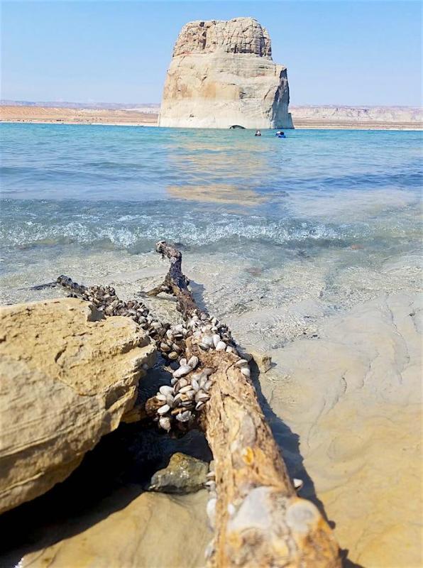
Lake Powell is already stressed and in crisis due to one invasive species: Quagga mussels. Since 2012 they have spread throughout the lake, clogged boat motors and impeded operations at Glen Canyon Dam, according to Clem Wasicek, a technician with the Utah Division of Wildlife. Decontamination stations last year cleaned and inspected about 120,000 water craft leaving the lake. “We are on the lookout for other invasive plants,” he says. “Eurasian watermilfoil and water hyacinth haven’t taken over our lake yet, and possibly New Zealand mud snails and crayfish, another invasive. It’s a very big mosh pit of things going on.”
Dr. Schmidt believes climate change will make way for other invasive species. “The most obvious invasives, that are a direct function of climate change and water supply management, are nonnative fish. There are two kinds: cold water, mainly trout, and warm water, mainly small mouth bass, gizzard chad (Dorosoma). As things get warmer nonnative reservoir fish might come up and swamp the system.”
The National Park Service is doing what it can but control is out of their hands. Rob Billerbeck is the NPS Colorado River Coordinator, and says their job is to “prevent unacceptable impacts to natural and cultural resources, and maintain natural processes. It’s really tough to answer questions of ecosystem health, and the condition of the park resources.”
But it now seems certain that there will be major deficits in Colorado River flows in the future, with unintended consequences to downstream users, hydroelectric power, recreation, fish, wildlife, water quality, flood control and all water-dependent ecological systems along the entire river. It all depends on whether the weather and the climate continue to change as predicted. And that’s a problem for everyone.
This series on the health of the Colorado River and its impacts on Canyonlands and Glen Canyon has been supported by a grant from The Water Desk, an independent journalism initiative based at the University of Colorado Boulder’s Center for Environmental Journalism.
National Parks Traveler, a 501(c)(3) nonprofit media organization, depends on reader and listener support to produce stories such as this one and other coverage of national parks and protected areas. Please donate today to ensure this coverage continues.
A copy of National Parks Traveler's financial statements may be obtained by sending a stamped, self-addressed envelope to: National Parks Traveler, P.O. Box 980452, Park City, Utah 84098. National Parks Traveler was formed in the state of Utah for the purpose of informing and educating about national parks and protected areas.
Residents of the following states may obtain a copy of our financial and additional information as stated below:
- Florida: A COPY OF THE OFFICIAL REGISTRATION AND FINANCIAL INFORMATION FOR NATIONAL PARKS TRAVELER, (REGISTRATION NO. CH 51659), MAY BE OBTAINED FROM THE DIVISION OF CONSUMER SERVICES BY CALLING 800-435-7352 OR VISITING THEIR WEBSITE WWW.FRESHFROMFLORIDA.COM. REGISTRATION DOES NOT IMPLY ENDORSEMENT, APPROVAL, OR RECOMMENDATION BY THE STATE.
- Georgia: A full and fair description of the programs and financial statement summary of National Parks Traveler is available upon request at the office and phone number indicated above.
- Maryland: Documents and information submitted under the Maryland Solicitations Act are also available, for the cost of postage and copies, from the Secretary of State, State House, Annapolis, MD 21401 (410-974-5534).
- North Carolina: Financial information about this organization and a copy of its license are available from the State Solicitation Licensing Branch at 888-830-4989 or 919-807-2214. The license is not an endorsement by the State.
- Pennsylvania: The official registration and financial information of National Parks Traveler may be obtained from the Pennsylvania Department of State by calling 800-732-0999. Registration does not imply endorsement.
- Virginia: Financial statements are available from the Virginia Department of Agriculture and Consumer Services, 102 Governor Street, Richmond, Virginia 23219.
- Washington: National Parks Traveler is registered with Washington State’s Charities Program as required by law and additional information is available by calling 800-332-4483 or visiting www.sos.wa.gov/charities, or on file at Charities Division, Office of the Secretary of State, State of Washington, Olympia, WA 98504.

Comments
Just wanted to point out a blatant error in the second paragraph. The Colorado does not run into the Gulf of Mexico. It runs into the Gulf of California.
Nice catch, Steven. We'll send the editor back to Geography 101.