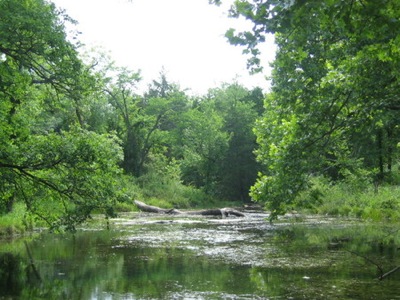
Most outdoor recreational activities at Chickasaw National Recreation Area center on the park's springs, streams, and lakes. This little pond is on Travertine Creek upstream from the Travertine Nature Center in the Platt Historic District. The Bromide Pavilion in the historic district was built in the 1930s by the CCC. NPS photos.
Chickasaw National Recreation Area in south-central Oklahoma was established as Sulphur Springs Reservation in 1902 and later redesignated Platt National Park. However, it took its present, much larger and diversified form in 1976 through the merging of historic Platt National Park with Arbuckle National Recreation Area and additional lands.
Today the nearly 10,000-acre park is an outdoor recreational cornucopia with partially forested hills, springs, streams and lakes offering camping, hiking swimming, boating, fishing, and other fun things to see and do. Here are some things you should know and do before your visit.
Before You Go
** Watch the 17-minute video
Oka, which tells the story of historic Platt National Park and Chickasaw's unique fresh water and mineral springs. "Oka" is the Cherokee word for water, and it is very appropriate. Chickasaw National Recreation Area was named to honor the Chickasaw Indian Nation, original occupants of this land. It remains the only unit of the National Park System established with the willing participation of an Indian tribe.
** Pick a season. As an outdoor recreational park, Chickasaw is generally busiest in the summer. Portions of the park can be very crowded on the weekends from Memorial Day through Labor Day. During the off season (Labor Day through Memorial Day), Chickasaw is a quieter place offering more solitude and better wildlife viewing.
** Consult the park map and get yourself oriented. The park has over a dozen entry and exit points, and getting around can be confusing even for return visitors.
Visiting the Park
** Drink the water. The sulphur-laden mineral waters of the Pavilion Springs and Vendome Well rise from the Arbuckle-Simpson Aquifer and serve as a reminder that the waters found here were so highly valued as to inspire the creation of the park in 1902. There is no scientific evidence to support claims of medicinal benefit, but lots of folks have attributed healing or restorative powers to the mineral waters flowing from these springs.
** Go for a drive. The Platt Historic District’s Perimeter Road is a scenic six-mile loop that takes you past nearly all of the park's principal historic features.
** Camp in the past. The park has six campgrounds with a total of 410 campsites (some available by reservation). Cold Springs Campground, which is located is in the park’s Platt Historic District, provides a "vintage" camping experience. Built by the Civilian Conservation Corps and opened to the public in 1940, the campground is largely unchanged and offers convenient access to the swimming areas along Travertine Creek.
If you are using a travel trailer or other RV, Rock Creek Campground will suit you best.
**Look at how they used to build them. The Platt Historic District provides many examples of 1930s era rustic style park facilities built by the Civilian Conservation Corps. Trails, roads, restrooms and spring pavilions found throughout the district stand today as a testament to the hard work and vision of the CCC.
** Stop by the Travertine Nature Center. Located on Travertine Creek near the eastern edge of the Platt Historic District, this facility serves as the park's main educational center. There you'll find exhibit dioramas, live animal displays (reptiles, amphibians, and birds of prey), an interactive learning area, and video presentations and ranger-led programs and hikes related to the park's natural and cultural resources.
** Have a family picnic or reunion at the Buckhorn or Veterans Lake Pavilions. These open- sided shelters, which are equipped with grills and water (but no electricity), can be reserved through the Special Park Use permit system. Call 580-622-3161 for information about fees and available dates.
** Take a hike. Chickasaw has over 20 miles of trails. Easy trails in the Platt Historic District connect the mineral spring pavilions and other principal cultural features. The Rock Creek multi-use trail system connects the Platt Historic District to the Lake of the Arbuckles. With all of the loops, this trail system is about 8 miles long. There are trailheads at both ends.
** Bring your bike, or if you prefer, your horse. As the name implies, the Rock Creek multi-use trail system is open to mountain bikes and horses as well as hikers.
** Go for a swim. Travertine Creek, one of the defining features of the Platt Historic District, has a series of traditional swimming areas. There are also swim beaches on the Lake of the Arbuckles at two developed areas (Buckhorn and The Point).
** Go paddling. Veterans Lake is open to canoeing, kayaking, and no-wake boat use.
** Enjoy boating on the Lake of the Arbuckles. The lake has four launch ramps that provide convenient access for power boating, sailing, and limited jet ski use.
You'll need a boating permit. Daily use or annual permits can be purchased at the Visitor Information Center and from fee machines located at several boat launch ramps (Buckhorn, The Point, and Guy Sandy).
** Wet a line. If you've got a valid state fishing license, you can fish in the Lake of the Arbuckles, Veterans Lake, and along portions of Rock Creek and Travertine Creek. White bass, largemouth bass, crappie, sunfish and catfish are popular catches.
** You can scuba dive in the Lake of the Arbuckles, except around boat docks or launch ramps, but you probably won't like the poor visibility (typically just 3-5 feet). In any event, don't plan to refill tanks in the park. The nearest place for tank refills is about 60 miles away in Norman.
** Yes, you can hunt deer, turkey, waterfowl, and upland game at Chickasaw. The enabling legislation for the park established sport hunting as a legal activity, consistent with state and federal game laws. Hunters must be aware of special rules, such as the current "antlerless only" stipulation for the deer harvest. Heavy hunting pressure limits success, and some areas of the park are closed to hunting for reasons of public safety, administration, wildlife management, or public use and enjoyment.
Postscript: A series of improvement projects are being implemented that will require brief closings of some Chickasaw facilities during the remainder of 2010. In a park that benefited so much from the work of the CCC back in the 1930s, it is a once in a generation chance to improve the visitor experience by bringing older facilities up to modern safety standards.
Resources
Lots of relevant information will be found at the park's home page.
The park map will help you get oriented.
Chickasaw National Recreation Area
1008 West Second Street
Sulphur, OK 73086-0201
580-622-3161
Story Categories:
A copy of National Parks Traveler's financial statements may be obtained by sending a stamped, self-addressed envelope to: National Parks Traveler, P.O. Box 980452, Park City, Utah 84098. National Parks Traveler was formed in the state of Utah for the purpose of informing and educating about national parks and protected areas.
Residents of the following states may obtain a copy of our financial and additional information as stated below:
- Florida: A COPY OF THE OFFICIAL REGISTRATION AND FINANCIAL INFORMATION FOR NATIONAL PARKS TRAVELER, (REGISTRATION NO. CH 51659), MAY BE OBTAINED FROM THE DIVISION OF CONSUMER SERVICES BY CALLING 800-435-7352 OR VISITING THEIR WEBSITE. REGISTRATION DOES NOT IMPLY ENDORSEMENT, APPROVAL, OR RECOMMENDATION BY THE STATE.
- Georgia: A full and fair description of the programs and financial statement summary of National Parks Traveler is available upon request at the office and phone number indicated above.
- Maryland: Documents and information submitted under the Maryland Solicitations Act are also available, for the cost of postage and copies, from the Secretary of State, State House, Annapolis, MD 21401 (410-974-5534).
- North Carolina: Financial information about this organization and a copy of its license are available from the State Solicitation Licensing Branch at 888-830-4989 or 919-807-2214. The license is not an endorsement by the State.
- Pennsylvania: The official registration and financial information of National Parks Traveler may be obtained from the Pennsylvania Department of State by calling 800-732-0999. Registration does not imply endorsement.
- Virginia: Financial statements are available from the Virginia Department of Agriculture and Consumer Services, 102 Governor Street, Richmond, Virginia 23219.
- Washington: National Parks Traveler is registered with Washington State’s Charities Program as required by law and additional information is available by calling 800-332-4483 or visiting www.sos.wa.gov/charities, or on file at Charities Division, Office of the Secretary of State, State of Washington, Olympia, WA 98504.
Comments
Great notes - but I'd like to make one additional comment.
The Chickasaw Nation has recently completed the Chickasaw Cultural Center's construction, and it is located adjacent to the Chickasaw National Recreation Area in Sulphur.
It's Grand Opening to the public will be July 24, 2010. You can learn more about it at http://www.chickasawculturalcenter.com/ - and, of course, at the Chickasaw Nation website ( http://chickasaw.net/ ) and the website for the Chickasaw Times ( http://www.chickasawtimes.net/ ).
Having been to the Chickasaws-only preview, I can tell you it is a fantastic experience, and anyone traveling to the Recreation Area should include it in their plans. There are photos of the Preview at http://chickasaw.net/newsroom/index_5334.htm and http://chickasaw.net/newsroom/index_5333.htm .
Actually, I'd advise you to try to visit as many of the natural springs as you can. Each one has its own particular properties and chemistry, all quite naturally. I found that fascinating myself, but I can be geeky that way.
We recently took an unplanned trip to Chickisaw NRA and I was pleasantly surprised by its incredible beauty and recreation opportunities. I had no idea such lush forest existed in OK. I would love to head back for a longer visit.
Oka isn't the Cherokee word for water. We say ama. I believe Oka is the Chickasaw word for water