
With seven Western states stuck at loggerheads over how to update a century-old compact governing who gets increasingly precious Colorado River water, the U.S. Bureau of Reclamation is again trying to force a solution and is asking the public to weigh in as the workhorse waterway itself chokes.
The once-grand Colorado feeds Glen Canyon and Lake Mead national recreation areas, but extended drought and climate change have left both reservoirs at historic lows and inching toward the "dead pool" level that means there's not enough water to release through their dams.
The fate of the river also impacts seven other national park units along the way, and in what some see as a positive twist, the low water levels are actually unearthing archaeological, cultural, and natural resources that were buried by the installation of dams — thus returning those areas closer to their natural condition.
The draft environmental impact statement (DEIS) the U.S. Bureau of Reclamation (BuRec) prepared for managing the two reservoirs that is currently open for public comments strives to chart a post-2026 course for a river that "faces exceptional challenges from prolonged drought and future uncertainty."
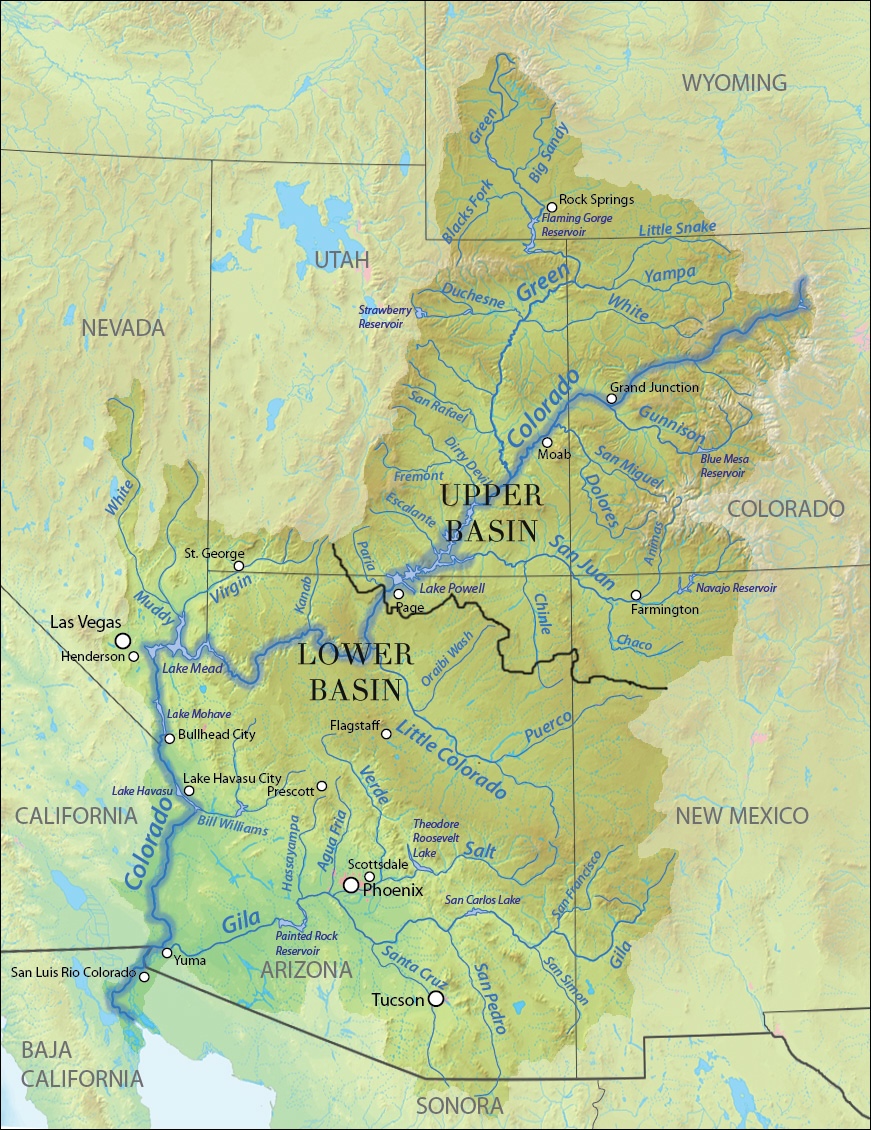
It's far from a brand new problem, but years of reports, discussion, and debate have failed to budge the states into compromise over allocation of the water. That task is not unlike a Gordian Knot, as the debate over balancing water needs and uses between the four Upper Basin states (Wyoming, Colorado, New Mexico, and Utah), and the three Lower Basin states (California, Nevada and Arizona) has been raging for years without resolution and has only been getting more complicated as climate change alters precipitation patterns that fuel a river relied upon by nearly 40 million people and one of California's most productive agricultural regions, the Imperial Valley.
While the Colorado River Compact of 1922 gave California the oldest water rights to the river, meaning the other states would have to sacrifice their water shares before California would lose a drop, the Upper Basin states argue that the long-running drought and climate change have so greatly reduced the water that feeds the river basin that any resolution to the current standoff must balance downstream needs with actual [e.g., 'wet water'] upstream supplies.
Twice in recent years the federal government has set deadlines for the states to find a compromise, and twice the deadlines have come and gone, although in 2007 an interim agreement was reached to prevent Lake Powell on the Utah-Arizona border from running out of water while also providing enough water downstream to Lake Mead in Nevada to minimize shortages. That agreement expires at year-end.
Now BuRec again is trying to force a settlement as the two reservoirs have fallen to historically low levels, putting in jeopardy drinking water, wildlife habitat, agricultural water, hydropower, and recreational pursuits.
"My take, my 50,000-foot take, is that it's limited, because the states have yet to come up with a preferred alternative," David Wegner, who spent a career with the bureau trying to manage the Colorado River basin's water supplies, said last week of the DEIS, "and until the states, collectively, and that's the seven basin states, determine where their line in the sand is with the federal government, it's hard to see an easy path forward."
The Fate Of The Parks
Greatly dependent on the outcome of negotiations are nine National Park System units found along the river, particularly Glen Canyon National Recreation Area and Lake Mead National Recreation Area. Both lakes Powell and Mead were less than two-thirds full in December. Compounding the water-flow problems created by diversions and climate-change impacts are the disagreements between the Upper and Lower basin states.
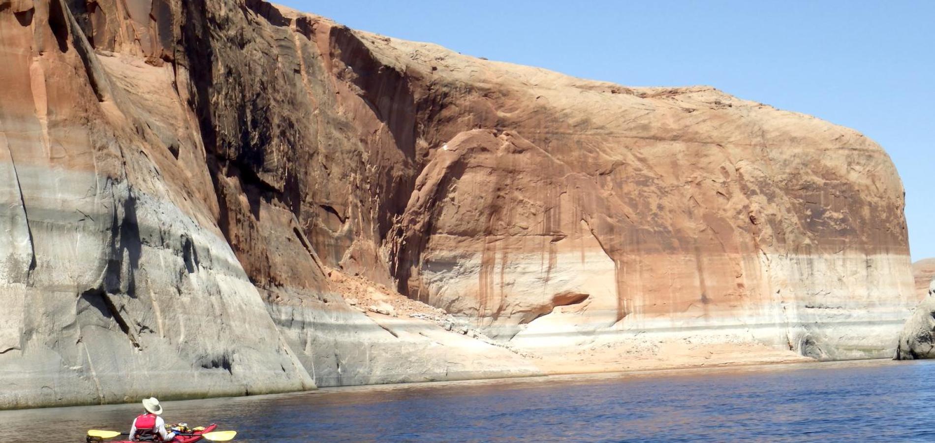
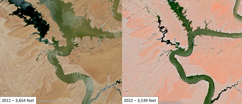
Both NRAs in recent years have spent millions of dollars to extend boat ramps to deal with declining water levels. Last July the surface of Lake Powell at Glen Canyon NRA was 3,557 feet above sea level, far below the 3,700-foot elevation of "full pool," yet about the same distance in feet from the 3,370-foot elevation of dead pool.
By Sunday, however, the lake's elevation had dropped another 20 feet to 3537.41 feet, according to BuRec. It will decline more in the coming months, and while spring runoff usually is counted on to reverse the declines, snowpack so far in the Upper Colorado Basin is far below normal in many areas. On Monday the combined snow water equivalent [the depth of water in the snowpack, if the snowpack were melted, expressed in inches] across measurement sites above Lake Powell stood at 68 percent of median for the date.
"This year, there may not be enough water to get Lake Powell back up to 3,560' or 3,575' this summer, unless something miraculous happens, and even then, with the lack of hydration in the soils, its runoff is going to be rough, no matter how much snow we get between now and May," pointed out Sinjin Eberle, the representative for American Rivers on the Glen Canyon NRA Adaptive Management Work Group that strives to find consensus for managing the Colorado River and the Glen Canyon Dam.
"Because there isn't a lot of flexibility built into the rules, whether it's the 2007 interim guidelines or a few of the alternatives that are in the new DEIS, [the two NRAs and their dams] could be managed to a very rigid set of rules that still requires 8.2-million-acre-feet, or 7.5-million-acre-feet going downstream, regardless of what the snowpack and the upper basin hydrology and the quality of the system is every day," he said last week.
100,000 New Acres
While the focus of the states seems to be fixed on what transpires from the 710-foot-tall Glen Canyon Dam and on downstream, concerns have risen on what's been transpiring upstream of that concrete wall. In his 2024 book, A Renewed Glen Canyon Emerges, Seth Arens noted that some 150 square miles, or roughly 100,000 acres, have resurfaced upstream of the dam inside Glen Canyon NRA due to shrinking Lake Powell.
Side canyons that have been underwater for decades have surfaced, drawing back wildlife and native vegetation that has flourished in them, both in the soils and hanging on cliffsides. Lake Powell waters in some side canyons have retreated five miles, according to Arens, and beavers have appeared elsewhere in recent years. Some rambunctious rapids on the Colorado River have reappeared in Cataract Canyon in Canyonlands National Park as well as in the Grand Canyon due to decline river flows.
"I would say it doesn't include not only upstream, but downstream issues, too," Wegner, who ran the Glen Canyon working group when it was first being set up, said of the DEIS. "Specifically, Grand Canyon National Park, and upstream, it's Glen Canyon National Recreation Area."
That might be because, until the recent years of drought and before the lands that have resurfaced, no one paid much attention to operations of the Glen Canyon Dam and their impacts upstream, he said.
"It really didn't come to pass until we got into these drought years," the scientist said. "Now you've got the upper end of Lake Powell, either on the San Juan (River) or the Colorado River arm, exposing a lot more new riverine habitat and riparian habitat and aquatic habitat."
Eberle at American Rivers agreed. The DEIS is "a lot of what we've seen before, which is, you know, a heavy focus on Powell and Mead," he said.
Even the DEIS reflects their point, noting high up in the executive summary that "[M]anagement strategies will primarily focus on the operation of Glen Canyon Dam and Hoover Dam but may include actions upstream and downstream of these facilities to protect critical reservoir elevations such as releases from the Colorado River Storage Project (CRSP) Upper Initial Units and approaches to enhance opportunities for Lower Basin water users to reduce water use."
The Park Service Perspective
While the Park Service would not make an expert available to discuss the DEIS and upstream conditions with the Traveler, it did provide written answers to questions.
"We are not sure who estimated the 100,000-acre figure, but gains in land area are certainly occurring when we consider Lake Powell's water levels have fallen below the maximum possible ("full pool") lake elevation (3,700 ft)," the agency said in an email. "Additional land area means larger amounts of terrestrial habitat and smaller amounts of aquatic reservoir habitat. This also means rivers feeding Lake Powell, such as the Colorado, San Juan, Escalante, and Dirty Devil, are slowly returning to river habitat conditions that existed prior to the construction of Glen Canyon Dam."
Reemerging lands have also brought to the surface archaeological resources and cultural sites.
The Park Service "has developed a plan and funding to support identifying, monitoring and protecting cultural sites as they emerge from the waters of Lake Powell and become exposed on dry land. The National Park Service is also working with the Bureau of Reclamation to identify agency responsibilities in managing cultural and natural resources as the waters of Lake Powell recede," an issue the agency said is addressed in the DEIS.
Staff at Glen Canyon NRA also installed last year a dust monitoring station to "identify trends and content in airborne dust within the park each year. This information will assist park officials in park planning that can include health advisories or annual management of recreation, visitor use, or vegetation."
As more land appears at Glen Canyon, the Park Service and its partners "monitor and survey certain plants, animals, habitat parameters, and physical characters within Glen Canyon National Recreation Area and Rainbow Bridge National Monument" to help guide management.
"In this way, Glen Canyon and Rainbow Bridge can be managed adaptively to address resource conditions and visitor use over time, including projects which can enhance habitat for native species of plants and animals," the Traveler was told.
"As Lake Powell has receded and new lands have been exposed, and as exposed land fluctuates throughout each year, our short- and long-term management decisions are continuously updated to match current and projected conditions," the email added. "Park staff monitor natural and cultural resources, evaluate emerging landscapes, and adjust management actions as needed to support native plants and wildlife while balancing visitor use and resource protection."
Whether those plans come to fruition remains to be seen.
"To this date, and even before, [BuRec] never took into consideration what the impact of drought and lower reservoir levels are going to be on the San Juan and the Colorado River through Cataract Canyon (in Canyonlands National Park)," said Wegner. "Never even considered it. ... And even now, especially in this administration, the loss of staff in the Park Service, there is nobody out there even looking at how these systems are recovering because of drought, because of low reservoir levels, and the exposure of a lot of those side tributaries that feed into side canyons that feed into Grand Canyon."
All the while, he added, the lower river levels have resulted in "a tremendous spike in native birds and plants and amphibians, etc. This is all from a scientific, environmental point of view. This is all good news."
Stories about:
Story Categories:
A copy of National Parks Traveler's financial statements may be obtained by sending a stamped, self-addressed envelope to: National Parks Traveler, P.O. Box 980452, Park City, Utah 84098. National Parks Traveler was formed in the state of Utah for the purpose of informing and educating about national parks and protected areas.
Residents of the following states may obtain a copy of our financial and additional information as stated below:
- Florida: A COPY OF THE OFFICIAL REGISTRATION AND FINANCIAL INFORMATION FOR NATIONAL PARKS TRAVELER, (REGISTRATION NO. CH 51659), MAY BE OBTAINED FROM THE DIVISION OF CONSUMER SERVICES BY CALLING 800-435-7352 OR VISITING THEIR WEBSITE. REGISTRATION DOES NOT IMPLY ENDORSEMENT, APPROVAL, OR RECOMMENDATION BY THE STATE.
- Georgia: A full and fair description of the programs and financial statement summary of National Parks Traveler is available upon request at the office and phone number indicated above.
- Maryland: Documents and information submitted under the Maryland Solicitations Act are also available, for the cost of postage and copies, from the Secretary of State, State House, Annapolis, MD 21401 (410-974-5534).
- North Carolina: Financial information about this organization and a copy of its license are available from the State Solicitation Licensing Branch at 888-830-4989 or 919-807-2214. The license is not an endorsement by the State.
- Pennsylvania: The official registration and financial information of National Parks Traveler may be obtained from the Pennsylvania Department of State by calling 800-732-0999. Registration does not imply endorsement.
- Virginia: Financial statements are available from the Virginia Department of Agriculture and Consumer Services, 102 Governor Street, Richmond, Virginia 23219.
- Washington: National Parks Traveler is registered with Washington State’s Charities Program as required by law and additional information is available by calling 800-332-4483 or visiting www.sos.wa.gov/charities, or on file at Charities Division, Office of the Secretary of State, State of Washington, Olympia, WA 98504.