You are here

National Park Service Grappling With Hazard Trees At Kings Canyon, Sequoia National Parks

Share
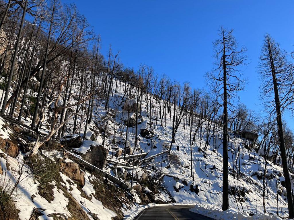
Burned trees from the KNP Complex Wildfire along the Generals Highway/NPS,Emma Jornlin

Burned trees from the 2021 KNP Complex wildfire along the Generals Highway/NPS,Emma Jornlin

Threats to visitors and park infrastructure posed by 12,000-15,000 "hazard trees" burned during the massive KNP Complex fire of 2021 at Kings Canyon and Sequoia national parks but still standing has the National Park Service formulating a plan to deal with them. The agency's preference is to remove tree hazards along roadways and the parks' developed areas within the fire's burn perimeter and then treat fallen debris around infrastructure and along roadways.

Public comment on the proposal and other alternatives is being taken through March 4. Details and comment space can be found here.

The KNP Complex was ignited by a large lightning event on the night of September 9, 2021. Despite immediate and aggressive suppression efforts, the two fires that initially comprised the complex merged in the coming days and burned rapidly through a large area of Sequoia National Park, and into Kings Canyon National Park, Sequoia National Forest, Bureau of Land Management lands, and lands under tribal, state, county, and private jurisdiction. The fire led to evacuation of many communities, closed public lands, and ultimately killed approximately 3-5 percent of the world’s population of mature giant sequoias

In the two parks the fire burned more than 88,000 acres.

Although the Park Service was able to restore access to major roads within the parks by removing some of the most imminent hazards, some roads remain closed following the KNP fire due to the density of tree hazards. Additionally, thousands of dead trees remain along roads open to public travel, which will become more dangerous over time if they are not removed. 

An environmental assessment prepared for the work evaluated three approaches to reducing public safety hazards from the trees:

  • Alternative 1, the "no action" alternative, which calls for no mitigation work.
  • Alternative 2, which calls for tackling the hazard trees and then treating buffer areas around the developed footprint of park infrastructure and up to 80 feet wide along roads to remove logs and debris resulting from toppling trees or those hazard trees downed by crews.
  • Alternative 3 calls for removing the hazard trees, but not creating and treating buffer areas.

According to park surveys, there could be more than 7,300 hazard trees along the Generals Highway corridor and more than 3,300 along the Crystal Cave Road in Sequoia National Park. Roughly 2,100 acres in the two parks would be involved in hazard tree mitigation, 922 acres in ensuing treatment work, and 61 linear miles of roadway, according to the EA.

The assessment analyzes options for treating fallen debris like pile burning, chipping and spreading on site, chipping and hauling from the parks, or hauling from the parks. Some wood may also be made available for public use via permit. 

The work would be expected to protect road corridors that serve as fire breaks, evacuation routes, and access for firefighters and other emergency personnel. Compliance with the National Historic Preservation Act and other applicable laws is also being conducted. 

If the Park Service's preferred alternative is chosen, work could begin as early as April.

Support National Parks Traveler

National Parks Traveler is a small, editorially independent 501(c)(3) nonprofit media organization. The Traveler is not part of the federal government nor a corporate subsidiary. Your support helps ensure the Traveler's news and feature coverage of national parks and protected areas endures. 

EIN: 26-2378789

Support Journalism about National Parks!

National Parks Traveler is a 501(c)(3) nonprofit.

A copy of National Parks Traveler's financial statements may be obtained by sending a stamped, self-addressed envelope to: National Parks Traveler, P.O. Box 980452, Park City, Utah 84098. National Parks Traveler was formed in the state of Utah for the purpose of informing and educating about national parks and protected areas.

Residents of the following states may obtain a copy of our financial and additional information as stated below:

  • Florida: A COPY OF THE OFFICIAL REGISTRATION AND FINANCIAL INFORMATION FOR NATIONAL PARKS TRAVELER, (REGISTRATION NO. CH 51659), MAY BE OBTAINED FROM THE DIVISION OF CONSUMER SERVICES BY CALLING 800-435-7352 OR VISITING THEIR WEBSITE WWW.FRESHFROMFLORIDA.COM. REGISTRATION DOES NOT IMPLY ENDORSEMENT, APPROVAL, OR RECOMMENDATION BY THE STATE.
  • Georgia: A full and fair description of the programs and financial statement summary of National Parks Traveler is available upon request at the office and phone number indicated above.
  • Maryland: Documents and information submitted under the Maryland Solicitations Act are also available, for the cost of postage and copies, from the Secretary of State, State House, Annapolis, MD 21401 (410-974-5534).
  • North Carolina: Financial information about this organization and a copy of its license are available from the State Solicitation Licensing Branch at 888-830-4989 or 919-807-2214. The license is not an endorsement by the State.
  • Pennsylvania: The official registration and financial information of National Parks Traveler may be obtained from the Pennsylvania Department of State by calling 800-732-0999. Registration does not imply endorsement.
  • Virginia: Financial statements are available from the Virginia Department of Agriculture and Consumer Services, 102 Governor Street, Richmond, Virginia 23219.
  • Washington: National Parks Traveler is registered with Washington State’s Charities Program as required by law and additional information is available by calling 800-332-4483 or visiting www.sos.wa.gov/charities, or on file at Charities Division, Office of the Secretary of State, State of Washington, Olympia, WA 98504.

The Essential RVing Guide

The Essential RVing Guide to the National Parks

The National Parks RVing Guide, aka the Essential RVing Guide To The National Parks, is the definitive guide for RVers seeking information on campgrounds in the National Park System where they can park their rigs. It's available for free for both iPhones and Android models.

This app is packed with RVing specific details on more than 250 campgrounds in more than 70 parks.

You'll also find stories about RVing in the parks, some tips if you've just recently turned into an RVer, and some planning suggestions. A bonus that wasn't in the previous eBook or PDF versions of this guide are feeds of Traveler content: you'll find our latest stories as well as our most recent podcasts just a click away.

So whether you have an iPhone or an Android, download this app and start exploring the campgrounds in the National Park System where you can park your rig.