
Editor's note: Yellowstone Caldera Chronicles is a weekly column written by scientists and collaborators of the Yellowstone Volcano Observatory. This contribution is from Christopher Schiller, postdoctoral scholar with the Department of Biology at the University of Washington, and Cathy Whitlock, Professor and Director of the Paleoecology Laboratory at Montana State University.
Today, Lower Geyser Basin in Yellowstone National Park is a treeless plain characterized by steaming ground, geysers, and mudpots. But thousands of years ago, it was heavily forested with less hydrothermal activity. Lake sediments tell the tale.
Lower Geyser Basin is the largest thermal basin in Yellowstone National Park (~14 km2 [5.5 mi2] of actively hot area) and includes some of the Park’s most famous hydrothermal features, like Fountain Paint Pots, Firehole Lake, and Great Fountain Geyser. It’s a landscape with a complicated past, sculpted by rhyolite lava flows, glaciers, hydrothermal activity, and climate change. Today, visitors see a flat, grassy landscape, where lodgepole pine cannot grow due to the hot ground.
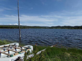
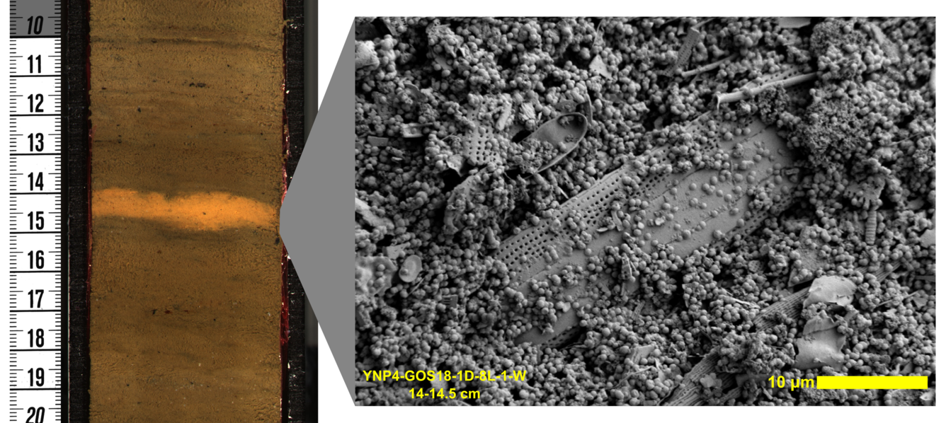
In 2018, a research team from Montana State University collected an 8.08 m (26.5 ft) sediment core from Goose Lake, in Lower Geyser Basin, to study how the ecosystem of the area was impacted by hydrothermal activity. The scientists studied a variety of fossils, as well as the lithology and geochemistry of the cores to reconstruct the environmental history. Pollen and charcoal were examined to reconstruct the vegetation and fire history, and diatoms (siliceous algae) documented changes in lake biology. The physical and chemical properties of the cores also provided information on past hydrothermal activity.
The Goose Lake record shows two distinct periods in the history of Lower Geyser Basin. In the earlier period (10,300 to 3,800 years ago), pollen and charcoal data suggest the presence of a lodgepole forest that became gradually denser, with more fire over time. This trend is repeated in many records around Yellowstone, and it is probably the result of the climate becoming cooler and wetter (especially in the summer). At the same time, there is evidence for hydrothermal activity from this period at Goose Lake—diatoms adapted to very warm water and wide alkalinity tolerances thrived in Goose Lake during this period. Sediments also contain abundant arsenic, known to be concentrated in thermal waters, and deposits of fluorite, a mineral produced by hydrothermal activity. Together, this tells us that Lower Geyser Basin was forested from 10,300 to 3,800 years ago, and that hydrothermal features were active near or within Goose Lake (there is no hydrothermal activity at Goose Lake today).
Later in the record (after 3,800 years ago), the landscape changed dramatically. First, pollen and charcoal data suggest an abrupt shift to a landscape with open grassland or steppe—much more similar to Lower Geyser Basin today. This open landscape is maintained by soils that are heated by hydrothermal activity below the surface (the grasses and herbs that thrive in Lower Geyser Basin today can take the heat, but lodgepole pine cannot!), suggesting that hydrothermal activity became widespread in Lower Geyser Basin about 3,800 years ago. At the same time, Goose Lake sediments ceased to be arsenic-rich and heat- and alkalinity-adapted diatoms declined, suggesting that hydrothermal activity at Goose Lake itself ceased.
It seems, then, that Lower Geyser Basin changed dramatically around 3,800 years ago, with hydrothermal activity stopping in some locations, like Goose Lake, but becoming widespread throughout the basin. Hydrothermal areas change due to a variety of factors. The 1959 Hebgen Lake earthquake, for example, disrupted hydrothermal features throughout the Yellowstone, including within Lower Geyser Basin. Periods of drought also impact hydrothermal features, such as a period around 650 to 800 years ago when eruptions stopped at Old Faithful Geyser during a severe, sustained drought. An earthquake or severe drought are both possible causes of the reorganization of Lower Geyser Basin around 3,800 years ago.
Yellowstone has been called a geo-ecosystem, since it is strongly influenced by geological processes, like volcanism, hydrothermal activity, faulting, and tectonic uplift, as well as changes in climate and hydrology. The Goose Lake data show how closely tied geological, climatic, and ecological forces were in the creation of Yellowstone’s iconic thermal areas. If you would like to read more about this work into the ecosystem changes at Lower Geyser Basin over time, see the recent research article in the journal Quaternary Research at https://doi.org/10.1017/qua.2021.42.
Stories about:
Story Categories:
A copy of National Parks Traveler's financial statements may be obtained by sending a stamped, self-addressed envelope to: National Parks Traveler, P.O. Box 980452, Park City, Utah 84098. National Parks Traveler was formed in the state of Utah for the purpose of informing and educating about national parks and protected areas.
Residents of the following states may obtain a copy of our financial and additional information as stated below:
- Florida: A COPY OF THE OFFICIAL REGISTRATION AND FINANCIAL INFORMATION FOR NATIONAL PARKS TRAVELER, (REGISTRATION NO. CH 51659), MAY BE OBTAINED FROM THE DIVISION OF CONSUMER SERVICES BY CALLING 800-435-7352 OR VISITING THEIR WEBSITE. REGISTRATION DOES NOT IMPLY ENDORSEMENT, APPROVAL, OR RECOMMENDATION BY THE STATE.
- Georgia: A full and fair description of the programs and financial statement summary of National Parks Traveler is available upon request at the office and phone number indicated above.
- Maryland: Documents and information submitted under the Maryland Solicitations Act are also available, for the cost of postage and copies, from the Secretary of State, State House, Annapolis, MD 21401 (410-974-5534).
- North Carolina: Financial information about this organization and a copy of its license are available from the State Solicitation Licensing Branch at 888-830-4989 or 919-807-2214. The license is not an endorsement by the State.
- Pennsylvania: The official registration and financial information of National Parks Traveler may be obtained from the Pennsylvania Department of State by calling 800-732-0999. Registration does not imply endorsement.
- Virginia: Financial statements are available from the Virginia Department of Agriculture and Consumer Services, 102 Governor Street, Richmond, Virginia 23219.
- Washington: National Parks Traveler is registered with Washington State’s Charities Program as required by law and additional information is available by calling 800-332-4483 or visiting www.sos.wa.gov/charities, or on file at Charities Division, Office of the Secretary of State, State of Washington, Olympia, WA 98504.
INN Member

The easiest way to explore RV-friendly National Park campgrounds.

Here’s the definitive guide to National Park System campgrounds where RVers can park their rigs.
Our app is packed with RVing- specific details on more than 250 campgrounds in more than 70 national parks.
You’ll also find stories about RVing in the parks, tips helpful if you’ve just recently become an RVer, and useful planning suggestions.

Comments
Interesting to read about the fluorite. I was in a Tertiary (I think) crater north of Rome (Italy) in 1970 sampling a thick deposit of fluorite insde the crater (severtal tens of metres thick, from memory), with local layers of gastropodes that obviously lived there and then. The in-situ CaF2 grade was 40% or 50%, but it was so fine-grained that it proved impossible to produce a commercial concentrate of >60%.
Soryy, I have forgotten the name of the place.