
Welcome to Whiskeytown National Recreation Area / Rebecca Latson
After a photographic three-day visit to Redwood National and State Parks along the Northern California coast, I drove about several hours east to spend a day-and-a-half at Whiskeytown National Recreation Area. Because my stay was so short, I spent all my time wandering around as much of Whiskeytown as possible, performing recon work for possible longer photography trips in the future. At Whiskeytown, there’s certainly plenty to do, see, and photograph and I wish I’d spent at least one more day there.

Map of Whiskeytown National Recreation Area / National Park Service
This national recreation area, located 8 miles west of Redding, California, suffered a devastating wildfire in 2018 that burned more than 97 percent of the recreation area’s 42,000 acres, along with 200,000 acres outside the park’s boundaries. Ultimately, eight people were killed and more than 1,000 homes and buildings were destroyed. According to the National Park Service, “The Carr Fire was the most destructive fire in the history of the National Park System.”

Fast forward to 2021 and much of the park’s infrastructure for visitation has been rebuilt and most of the park has reopened to the public, thanks to the hard work and dedication of park staff and their partners.
For you photographers, there’s plenty to see through your camera’s viewfinder. Great places for landscape shots can be found at large and small pullouts on either side of Whiskeytown Lake. At this park, you’ll be capturing a mixture of stark and beautiful. You might photograph a kayaker paddling past hillsides dotted with the charred toothpicks of trees as the green promise of new growth sprouts between those trees.

Paddling the lake in the Whiskey Creek area, Whiskeytown National Recreation Area / Rebecca Latson
If you’re on California Highway 299 heading east toward Redding, there’s a gravel pullout to your right, past the turnoff for the Carr Powerhouse, with camera-ready views framed by bare tree limbs, exemplifying beautiful and haunting scenery of a part of Whiskeytown lake and surrounding mountains. You’ll need to slow down and look carefully for the pullout, though, because it’s easy to zoom past. You’ll also need to watch for the traffic behind you as CA 299 is a busy highway.
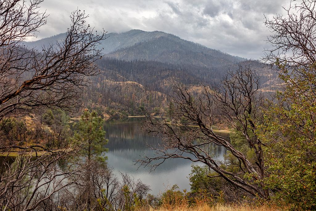
Whiskeytown scenery on an overcast, autumn day, Whiskeytown National Recreation Area / Rebecca Latson
The visitor center has a great view of Whiskeytown Lake and surrounding mountains, but power lines run through the scene. So, unless you want to go to the trouble of removing (“cloning out”) the entire length of the powerlines, I suggest driving a little further south to the small gravel pullout between the road to park headquarters and the larger East Beach gravel parking area. This small turnout offers a lovely view of the lake and landscape framed by leafy trees.
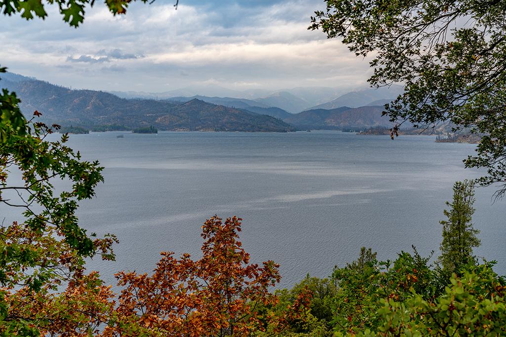
Whiskeytown Lake landscape, Whiskeytown National Recreation Area / Rebecca Latson
Whiskeytown National Recreation Area was home to pioneer-settlers including Charles Camden and Levi Tower, two gold miners turned best friends and business partners. The two developed land around the town of Shasta and built hotels, a toll road, and established fruit orchards to supply the town with fresh food. Learn more about this location in the book Whiskeytown National Recreation Area or bring home an official park product from Western National Parks Association.
Don’t forget to actually stop at the East Beach lot and capture a leading line shot of the steps you’ll take down to the shoreline to photograph lake and mountain scenery. On a much clearer day than when I visited, it’s possible to capture sunset images from this beach.

The steps down to East Beach, Whiskeytown National Recreation Area / Rebecca Latson

A view on East Beach, Whiskeytown National Recreation Area / Rebecca Latson
Speaking of leading lines, park in the lots on either side of the Clair A. Hill Whiskeytown Dam, further down the road, for a great leading line image of the road across the lake and up into the mountains. Just look both ways for traffic, first.
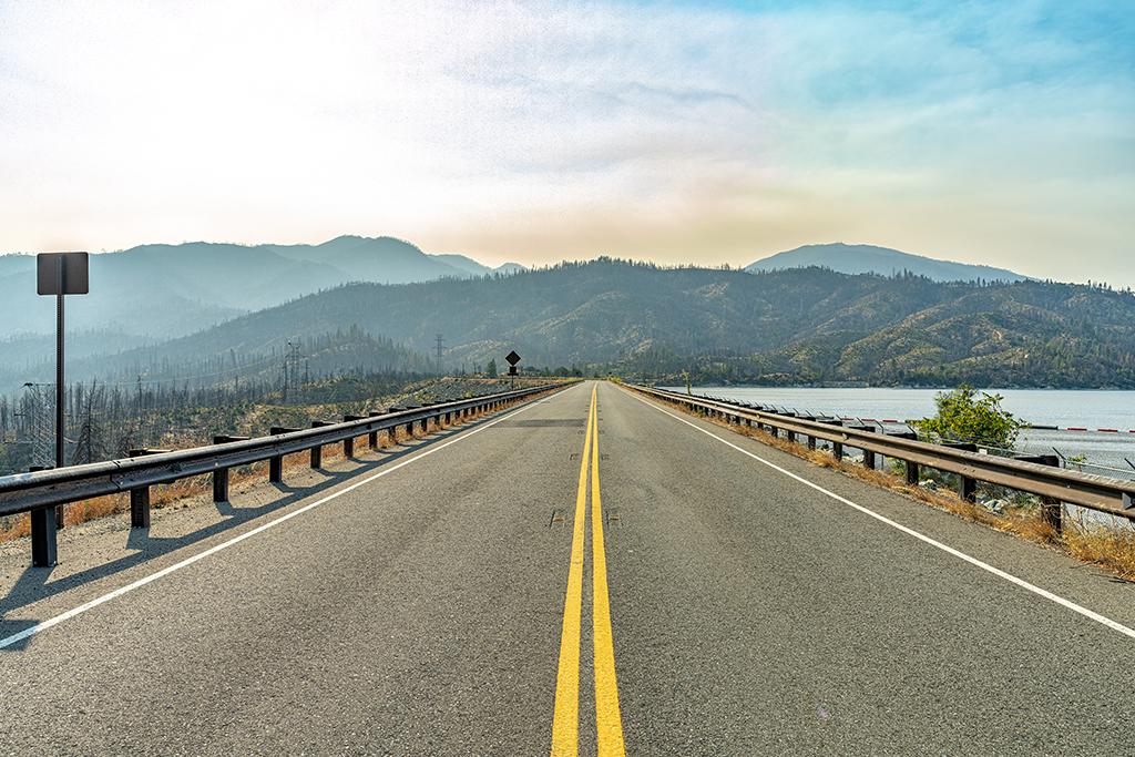
The road across the dam, Whiskeytown National Recreation Area / Rebecca Latson
There are also one-car-sized pullouts along South Shore Drive allowing for north-facing glimpses of the lake landscape.

An autumn view of Whiskeytown Lake, Whiskeytown National Recreation Area / Rebecca Latson
The waterfalls in this park are nice rewards at the end of the trail, affording a photographer the opportunity to practice their silky water technique. I walked the very short (.3-mile) paved trail to Crystal Creek Falls and had the whole place to myself. During the October day I visited, it was quiet and peaceful, albeit smoky from the wildfires raging in other parts of the state.
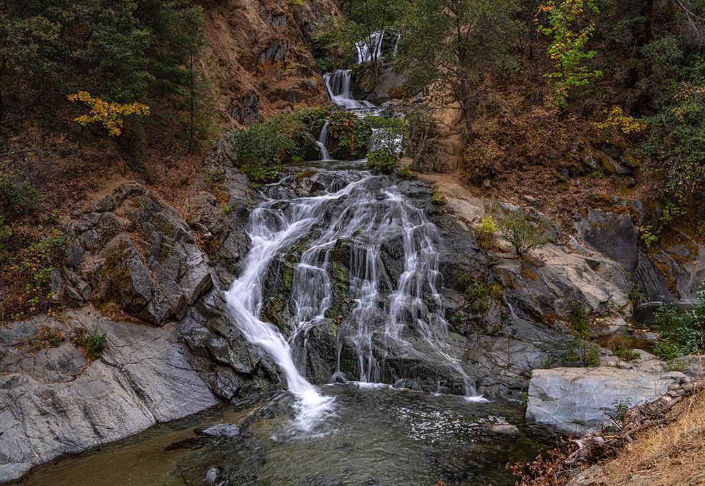
An early autumn morning at Crystal Creek Falls, Whiskeytown National Recreation Area / Rebecca Latson
For any of your photos involving water scenes - which would be quite a few, since water-based recreation rules here at Whiskeytown – I advise the use of a circular polarizing filter (CPL). This handy little filter that should be in every photographer’s gear bag acts like your sunglasses to cut through glare and reflections, bringing out that beautiful teal-green color of the lake water. Just turn the outer ring of the filter to see for yourself. The caveat is that you need to be at an angle to the sun in order to access the CPL’s full capabilities.
Fun Fact: “For several decades, the U.S. Postal Service apparently refused to acknowledge the name of the town because it felt Whiskeytown was an unwholesome name. However, upon the community’s 100th anniversary in 1952, the Women’s Improvement League of Whiskeytown successfully lobbied the Postal Service to make the historic name official.” (Source: National Park Service) Learn more about Whiskeytown NRA or commemorate your visit with any of these official national park products from Western National Parks Association.
This park is great for bird photography, too. Keep your eyes and ears open for Great Egrets, herons, Western scrub jays, and hairy woodpeckers, and even hummingbirds, to name a few. The park's website even has a page specifically for the birds of Whiskeytown. My advice when capturing bird photos is to bring along a long lens (aka telephoto) with a focal length of 200mm or more. The bird images you see below were all captured with my 100-400mm lens at the 400mm focal length, then cropped for a slightly closer view.
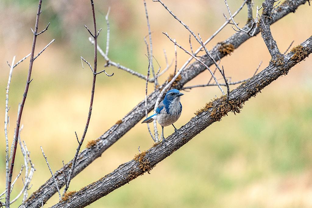
Western scrub jay, Whiskeytown National Recreation Area / Rebecca Latson

Hairy woodpecker, Whiskeytown National Recreation Area / Rebecca Latson

Checking out the action at the Whiskeytown dam, Whiskeytown National Recreation Area / Rebecca Latson

A lone great egret, Whiskeytown National Recreation Area / Rebecca Latson
This video was captured on the fly (no pun intended). The Whiskeytown visitor center kept its door open to help with air flow in that small, enclosed area, and before we realized it, a little hummingbird had flown in and couldn't find its way out. It kept trying to escape via the windows except that pesky glass was in the way. So, I suggested to the ranger that she use a couple of wide-brimmed hats to steer the little guy back out the door.
Helping a little hummingbird, Whiskeytown Visitor Center, Whiskeytown National Recreation Area / Rebecca Latson
Depending upon the time of year you visit Whiskeytown, you’ll either see all sorts of wildflowers, or a few. In addition to wildflowers, you can photograph interesting vegetation, like the shiny-leaved California Yerba Santa, a plant with hardy seeds that will germinate after a fire. For all of these shots, I used a telephoto lens for flower close-ups.

California indian pink, Whiskeytown National Recreation Area / Rebecca Latson

Yerba santa in the Whiskey Creek area, Whiskeytown National Recreation Area / Rebecca Latson
This recreation area is home to quite a bit of history, too, beginning with the Wintu and their ancestors, who have inhabited the area for the past millennia. The gold rush of California brought people from all over the world seeking to “strike it rich.” You can read about this and about a couple of individuals who lived in the area at the Tower House Historic District. Park in the large lot and walk the bridge over Clear Creek for images of the creek, birds, the Tower Hotel (saved from the ravages of the Carr Fire), and the solitary, haunting gravesite of Levi Tower.

Tower House Hotel, Tower House Historic District, Whiskeytown National Recreation Area / Rebecca Latson

Levi Tower gravesite, Tower House Historic District, Whiskeytown National Recreation Area / Rebecca Latson
While watersports may take center stage, there are all sorts of hiking trails in this park, too, from easy to strenuous. Along these trails, you’ll see close-up the results of the Carr Fire and the regrowth of vegetation. An abundance of caution is advised when out on the trails. Hikers should be alert for the unexpected hazard of falling tree limbs and trunks. Off trail, blackened forest debris hides holes and other pitfalls from unwary steps. So, stick to the trail.
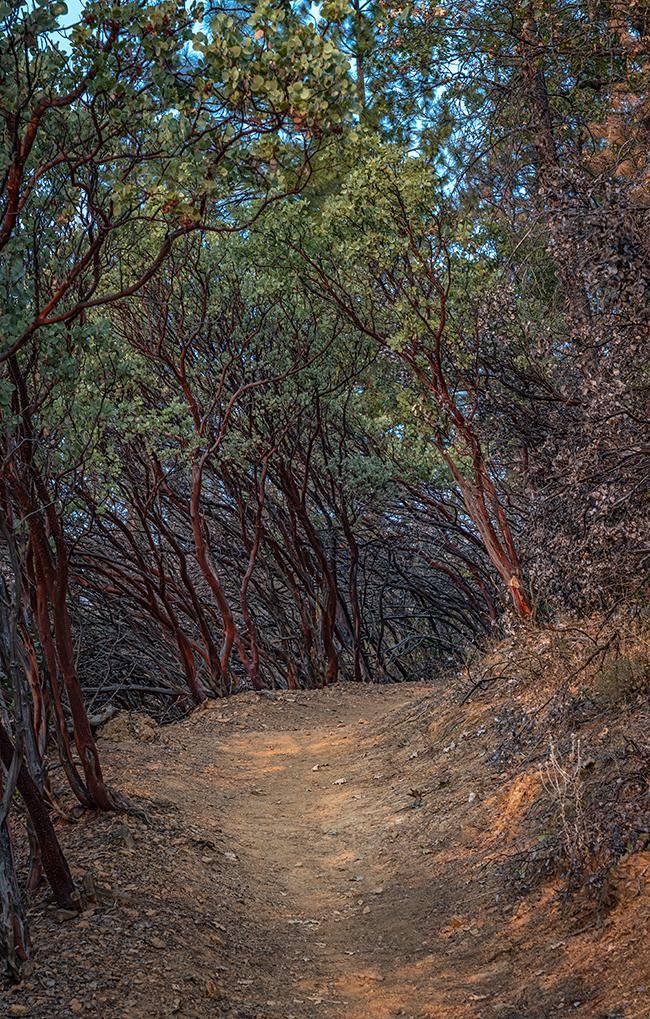
A shaded trail, Whiskeytown National Recreation Area / Rebecca Latson
Thanks to serious and steady dedication in rebuilding Whiskeytown’s infrastructure in addition to restoring the landscape, this National Park System unit remains popular despite the ravages of the Carr Fire and is a fine example of a park that’s risen from the ashes of the Carr Fire. Yes, reminders of that wildfire’s damage surround you, but so do the promises of regrowth.
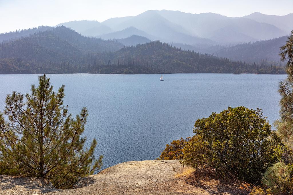
Serene sailing under a smoky sky at Whiskeytown Lake, Whiskeytown National Recreation Area / Rebecca Latson


Comments
Nice photos. I did want to correct text statement below first map . It says 8 miles East and it is actually West
Thanks for the catch, Jay! Correction made.
It's not that pretty right now. The lake is a mud puddle.
Thank you Rebecca for visiting our beautiful whiskeytown lake. The locals and whiskeytown workers have cleaned up and made the area presentable for enjoyable visits. The Carr fire denuded the hills extremely, so much so that rains brought tons of runoff of silt that settled into the Brandy creek swimming area. The dead branches and brush and silt is cleaned, cleared and dredged out for recreational enjoyment. It is a monumental task and we appreciate the parks and all of the groups involved that help to keep whiskeytown lake open and recovering.