Winter, the season with cold, snow, short days and long nights, can be a challenging one to explore the National Park System. Yet it holds surprises revealed by shimmering lights darting across the night sky, in tracks of what passed the night before across the snowscape, and in congregations of wildlife.
Of course, it can also be the season of showers of pelting sleet, temperatures that freeze your skin, and blizzards that interupt your plans. I've been fortunate to have enjoyed just about all of that: 20-below-zero temperatures at Old Faithful in Yellowstone, sun on my face while cross-country skiing on the North Rim of Grand Canyon, and white-outs.
So what do you do if you want to schedule one or more trips into the cold weather parks over the next three months? Here are some suggestions and tips from across the park system. Many parks offer ranger-led snowshoe hikes, including some under the full moon, so check with a park to see when those opportunities might fall this winter. Some also offer special programs for school children.
Just remember, conditions can change quickly depending on the storm track, and the ongoing coronavirus pandemic might alter some long-familiar programs in the parks. Also, if you're coming from lower elevations -- sea level, anyone? -- you might find yourself needing to acclimate a day or two to much higher elevations, so be sure to take that into account with your plans.
Cross-country Skiing and Snowshoeing

Acadia National Park, Maine
There are 45 miles of carriage roads in the park that offer the perfect setting for cross-country skiing and snowshoeing once the snow cover gets deep enough. Ski tracks are sometimes laid down by volunteers on sections of the carriage roads when snowfall exceeds four inches; nearly 32 miles are designated for grooming when conditions and time permit. Check the Friends of Acadia Winter Trails Association webpage for trail status and when grooming occurs.
You may also cross-country ski on unplowed park roads. But be careful, as snowmobiles also are permitted to use most of these park roads. Hiking trails can be rough on snowshoes unless there's a really significant snow cover.

Blue Ridge Parkway, North Carolina and Virginia
This 469-mile sinuous scenic drive can be a particularly rewarding destination for those who love to play in the snow. Many state highways and county roads intersect this mountainous landscape, providing relatively easy access. While sections of the parkway might shut down to wheeled traffic under heavy snows, those closures open the parkway to cross-country skiers and snowshoers.
Among the areas along the parkway that Randy Johnson, author of Southern Snow, The New Guide to Winter Sports from Maryland to the Southern Appalachians, recommends are Julian Price Memorial Park and Moses H. Cone Park. "The 4,200-acre Price Park between mileposts 295.9and 297.2 has fine cross-country opportunties and a number of good winter hikes," he writes. At Moses Cone, Johnson writes, "the white pine forests appear nearly virgin in size and grandeur. Under this canopy, cross-country skiers glide through a silent and beautiful setting, one of the sport's high points in the Southeast."
More detailed descriptions of the parkway's options can be found in Johnson's book.

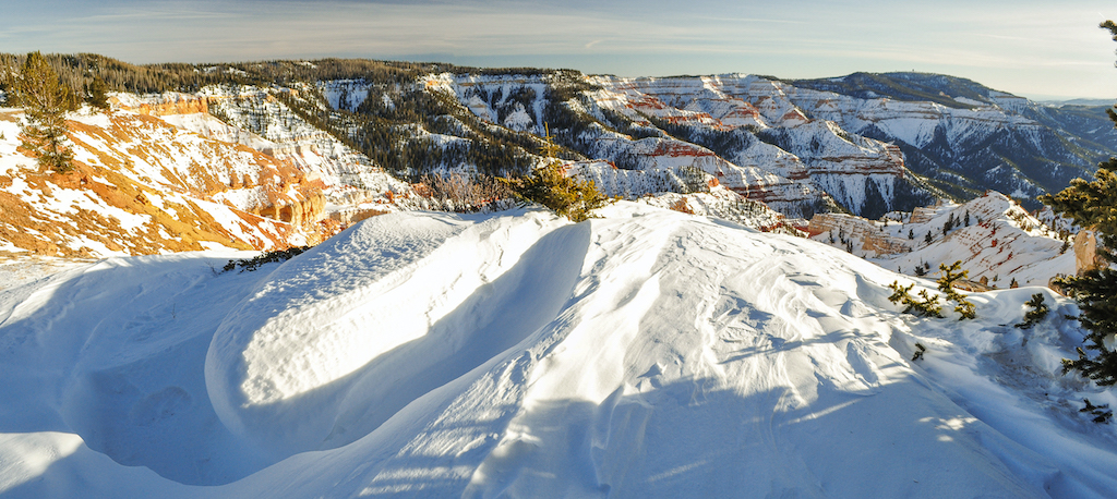
Bryce Canyon National Park, Utah
Winter delivers solitude in bulk to Bryce Canyon. During one winter trip I had the Upper Inspiration Point Overlook to myself. I glanced down upon Natural Bridge, with two others. I had Farview Point to myself. I walked the Queen's Garden-Navajo Loop Trail (minus the Wall Street section, which is closed in winter) with my own thoughts. I watched the sun come up from Bryce Point with a hardy Texan and his two tripod-steadied cameras.
This redrock icon in Utah offers mile after mile after mile of cross-country and snowshoeing possibilities. The 18-mile-long Rim Road is as good as any place for skiing, and the views can't be beat. The Fairyland Point and Paria View roads are open for cross-country skiers and snowshoeing. Cross-country skiing is permitted above the canyon rim; however no skiing, snowboarding or other sliding is allowed below the rim.
Snowshoeing can be limited here, depending on the storm track. If you want to go below the rim and into the hoodoo-studded landscape, make sure that there’s enough snow. If there’s not, check out the Fairyland Point or Paria View roads. If your visit coincides with a full moon, check at the visitors center about ranger-led full moon snowshoe hikes.
If you're determined to watch the sun rise from Bryce Point, and to enjoy the illumination of the main amphitheater, plan on driving to the point between 6:30 a.m. and 7 a.m. (in the visitor center they post the next day's sunrise, so use that as a gauge). Since it possibly will be very dark, as opposed to somewhat dark, when you reach the point's parking lot, you might feel good toting a flashlight to see where the best footing is on the way to the overlook. Just keep the beam pointed on the ground in front of you, as some photographers might already be on the overlook and using long exposures to capture the dawning day. A misguided beam of light would not go over well in that situation.
Cedar Breaks National Monument, Utah
State Route 148 usually is transformed into a marked and groomed snowmobile route, and the rest of the park is transformed into a winter playground for those on snowshoes and skis when the snowstorms strike. The oranges, creams, and snowy whites of the main amphitheater create spectacular photos, and the ancient bristlecones add chararacter and history to this monument.

Crater Lake National Park, Oregon
Crater Lake features a variety of marked and unmarked routes for cross-country skiing. Choose a route through forests, along West Rim Drive to lake overlooks, or to Vidae Falls along the East Rim Drive. Maps and descriptions of the ski trails are available in the park newspaper.
None of the routes are groomed, and they are sometimes deep and difficult to follow. Conditions may range from powder to slush or ice. Skiers may need to break trail. Snowshoers often use the same routes.
Just be careful not to ski or snowshoe too close to the rim of the crater, as visitors have lost their lives when snow cornices they thought were sound broke away under their weight. Marvel at the blue waters down below from a safe distance.
Each winter, approximately 80 skiers and 40 snowshoers travel all the way around Crater Lake. It’s a trip that can be exceptionally rewarding, with unforgettable views. It can also be physically and mentally demanding—a test of endurance and outdoor skills. A backcountry permit is required for entire tour.
March and April are the most popular months to complete the loop. Spring provides more hours of daylight than the winter months and longer periods of fair weather. When the weather is clear, the 31-mile loop takes an average of three days to complete. Storms, however, force many parties to turn back or to spend extra nights. The route is unmarked, difficult to follow in places, and crossed by a number of avalanche paths. Those attempting the trip should be experienced in winter camping, backcountry travel, and avalanche safety.

Glacier National Park, Montana
Winter can be a wonderful season to visit Glacier, as few others do, so you'll have the snowy landscape largely to yourself.
There are miles of skiing and snowshoeing possibilities in Glacier but, as with any other park setting, take into account your skiing ability and backcountry knowledge, and check with rangers for weather and snow conditions. Familiarity with the park and good maps are great to have, as most ski routes are not marked. A topographic map will help. Plan to break trail on less popular routes.
Going-to-the-Sun Road closes to wheeled traffic at Lake McDonald Lodge, but there is still much to do. Try a 16-mile round-trip cross-country ski from Lake McDonald Lodge to Avalanche Lake, or strap on a pair of snowshoes and explore any of the forests accessible via the roads.

Grand Teton National Park, Wyoming
Once the snow is deep enough the Teton Park Road is closed to wheeled traffic and open to cross-country skiers and snowshoers. The road gets groomed for cross-country skiing (thanks to the Grand Teton National Park Foundation) from the Taggart Lake parking area to Signal Mountain.
You also can explore trails along the Moose-Wilson Road, the Colter Bay area, or farther north near Flagg Ranch. Some areas are closed in winter to lessen the impact on wildlife, so be sure to check at the Craig Thomas Discovery and Visitor Center for that information.
Intrepid skiers will use Jackson Lake, once it freezes solid, to cross into the canyons of the Tetons for some earned turns.
Looking for wildlife? Check out the nearby National Elk Refuge.

Great Smoky Mountains National Park, Tennessee/North Carolina
When it snows in the Smokies, the 7-mile road to Clingmans Dome is closed to vehicles but available for cross-country skiing or snowshoeing. There’s even a volunteer Nordic Ski Patrol that serves as a contact point for visitors using Clingmans Dome Road during winter.
Indiana Dunes National Park, Indiana
This lakeside park offers snowshoers 45 miles of trails perfect for exploring winter. Cross-country skiers also are welcome, and most repeaters head to the Ly-co-ki-we and Inland Marsh trails for skinny skiing. The best option for cross-country skiing is the Glenwood Dunes Trail. This 6.4-mile trail is a series of interconnecting loops that meander through gently rolling wooded dunes.
The 2.9-mile Tolleston Dunes Trail System winds amid varied habitats ranging from oak savanna to wetlands and is a good choice for advanced skiers. There are some difficult hills that can be tricky to navigate.
Hikers and visitors using snowshoes are asked to walk to the right of the cross-country ski tracks whenever possible. Sledding and snowmobiling are not permitted.
Another popular winter activity at Indiana Dunes is admiring the shelf ice that often forms along the edge of Lake Michigan during periods of cold weather. But don't be fooled. Despite its appearance, the shelf ice is not solid. In fact, due to the way it is formed, the shelf ice has numerous air pockets. It can be difficult to tell where the ice ends and the beach begins.

Lassen Volcanic National Park, California
Backcountry skiers flock to Lassen because of its wide expanses of terrain on and around Lassen Peak. More than half of the year Lassen is blanketed in snow. Although the park highway closes to through traffic during the winter months, the Southwest and Manzanita Lake areas remain accessible year-round. Visit the park's year-round Kohm Yah-mah-nee Visitor Center (see hours) and enjoy the steep slopes in the Southwest Area or explore the gentler terrain in the Manzanita Lake area.
If you’re looking for sledding fun at Lassen, the steep slopes in the Southwest Area of the park, near the Kohm Yah-mah-nee Visitor Center, are popular with experienced sledders. Be sure to choose a slope that is right for your group and the conditions because sledding is the No. 1 cause of visitor injury in the winter season. Each winter rangers treat and evacuate sledders with head and spine injuries, lacerations, and broken bones. Icy snow creates very fast sledding conditions and trees and rocks abound in this area.
The Sulphur Works hydrothermal area is accessible via a two-mile roundtrip route along the snow-covered park highway. The hydrothermal features are visible year-round due to the high temperatures of steam vents, mudpots and boiling springs. Visitors are encouraged to visit these special areas during the winter season, but are reminded that traveling too close to these areas has resulted in severe injuries for previous visitors. The snow surrounding hydrothermal features can look solid but may actually be a weak snow layer hiding poles of acidic boiling water. Reduce your risk of injury by maintaining a safe distance.
Marsh-Billings-Rockefeller National Historical Site, Vermont
This park near Woodstock, Vermont, has 20 miles of trails and carriage roads that, come winter and snowfall, are used only for cross-country skiing and snowshoeing. The carriage roads date to the late 1800s when Frederick Billings oversaw their construction through the pastures and woodlots on the property. Those woodlots, by the way, now host some 400-year-old hemlocks. The average winter snow fall here is 80 inches, and the trails are usually in good condition for skiing between January and March, according to park officials.
The Woodstock Resort Corporation holds an easement on all of the park's carriage roads and trails for winter use. The nordic center typically maintains a groomed network of approximately 7 kilometers of trails starting at Prosper Parking Area as part of a larger trail network of 30 kilometers surrounding the village of Woodstock.

Mesa Verde National Park, Colorado
When there’s enough snow, the park grooms several trails for snowshoeing and skiing, while parts of the Wetherill Road are available for ungroomed skiing. Winter trails can be found on the Cliff Palace Loop, Wetherill Road Trail, Prater Canyon and Morefield Campground trails. The total distance covered by these trails is about 28 miles, and 20.4 of those miles aren't groomed. The ungroomed skiing is located on Wetherill Road, which is closed to vehicular traffic.

Mount Rainier National Park, Washington
There's already enough snow for exploring around the Paradise area on snowshoes. Once the snow gets deep enough, the area opens to sledding and tubing. Watch the park's website and social media channels for updates.
The Longmire area also has a number of trails perfect for snowshoeing once the snowpack builds. According to the Park Service, on heavy snow years there could be as much as 5 feet of snow on the ground around Longmire.

Olympic National Park, Washington
Come winter there's a nice little ski area atop Hurricane Ridge, and some wonderful snowshoeing terrain to explore, ski trails to follow, and tubing to be had.

Pictured Rocks National Lakeshore, Michigan
More than 20 miles of cross-country trails crisscross the lakeshore (and ice climbing is another highly popular outlet at the lakeshore). The Sand Point Snowshoe Trail is a 1.5 mile-long-loop trail beginning on Sand Point Road at the Sand Point Marsh Trailhead just a quarter-mile south of the park’s headquarters.
Other snowshoe treks at Pictured Rocks include the 5.6-mile round trip into Miners Falls from the “end of plowing” on the Miners Castle Road, the 6.5-mile round trip to Miners Castle from the “end of plowing” on the Miners Castle Road, the 6-mile round trip into Beaver Lake from H-58 via the summer access road, and the 10-mile trip to Chapel Falls from H-58 via the summer access road.
You can pick up the North Country National Scenic Trail near the Munising Falls parking lot or the Grand Sable Visitor Center parking lot and follow it for many miles.
Trails are marked with blue diamonds. Maps are located at trailheads and at trail intersections. Watch and listen for grooming equipment when you ski. Some Munising trail loops feature interpretive wayside exhibits along the route. Be sure to stop at these to learn about the interesting natural and human history of the area.
Though wildlife is pretty scarce in winter, tracks of otter, red squirrel, American marten, fisher, deer, grouse, raven, and snowshoe hare are often seen.

Rocky Mountain National Park, Colorado
Rocky Mountain National Park is 415 square miles of wonderful winter wilderness. You can backcountry ski steep slopes, kick-and-glide Nordic trails, snowshoe into the high country, and on occasion even find dry ground for hiking if you don’t have the gear for snowy pursuits.
Most park trails can be explored with snowshoes. A few pieces of equipment are essential: you will need a pair of snowshoes and waterproof boots. Poles are helpful for maintaining balance, but optional. Waterproof pants or gaiters help keep you warm and dry.
Cross-country skiers might want to focus on the west side of Rocky Mountain National Park, as the terrain and generally deeper snows make for better for ski conditions. On either side of the divide, you can snowshoe on most park hiking trails. Cross-country skiing works well on Trail Ridge Road once it’s snow-covered.
For climbers, Hidden Falls, Jewel Lake, All Mixed Up, Petite Grepon and Grace Falls are all popular ice-climbing destinations.
Hidden Valley is the one place in Rocky Mountain where sledding is allowed. No tows are provided, and you must provide your own plastic sled (sleds with metal runners are NOT allowed), saucer, or tube (if you don't bring your own they may be rented in Estes Park at most any outdoor shop). You walk your sled/saucer/tube up the hill and slide down. It's a pretty gentle hill, being the bottom of the bunny slope of the former Hidden Valley Ski Area.
Wildlife still call the park home in winter—elk and bighorn can be found, and birding for colorful Pine Grosbeaks, raucous Gray Jays, and the hard-to-spot White-tailed ptarmagins can consume all the daylight hours.
Look for moose along the Colorado River on the park's west side. Elk and mule deer are most active at dusk and dawn, and are usually seen in meadow areas. Look for bighorn sheep along the Highway 34/Fall River corridor on the park's east side. Coyotes may be seen any time of day.
Members of the Jay family, including Steller's jays, with their striking blue bodies and crested heads, gray jays, Clark's nutcrackers, and the iridescent, long-tailed black-billed magpies are commonly seen in the park.

Sequoia and Kings Canyon National Parks, California
Is there a more sublime snow experience than skiing or snowshoeing through the giant trees found in these two parks? Trails can be found in both the Giant Forest of Sequoia and Grant Grove in Kings Canyon.
According to park staff, many trails are suitable for snowshoeing when there's enough snow. You can rent snowshoes at Lodgepole Market, Grant Grove Gift Shop, or bring your own. Purchase a map of ski trails at any visitor center and look for reflective markers on trees that show popular paths. When snowshoeing, stay clear of ski tracks. Check the park newspaper's winter safety tips.
Check out the 2-mile long Sunset Rock beginner trail in the Giant Forest to the 6.2-mile Alta Trail that takes you from Wolverton to the Giant Forest. All told, there are more than 30 miles to explore in this land of the giants.
If there is sufficient snow, many areas of the park may be accessed by skis. Both Giant Forest and Grant Grove offer ski trails through sequoia groves.
If you like to ski, test yourself on the Trail of the Sequoias, an advanced intermediate route, or the Pear Lake Trail, recommended for advanced skiers. This 12-mile round-trip takes you to the 9,500-foot summit of “the Hump.”
For well-prepared and skilled winter travelers, the challenges of exploring park wilderness lands in winter can lead to a rewarding experience. Be familiar with ways to stay safe in cold or snowy weather conditions; be prepared for emergencies, and remember that weather in these mountains can change suddenly. Wilderness permits are required for all overnight trips away from designated campgrounds. Whether you stay at Pear Lake Winter Hut or create your own campsite, enjoy your adventure and be safe.
Sleeping Bear Dunes National Lakeshore, Michigan
The Sleeping Bear Heritage Trail that runs 22 miles between Empire and the Bohemia Road is groomed for both classic track and skate skiing. Other ski trails are not groomed but are usually well tracked by previous skiers.
Sleeping Bear also offers ranger-led snowshoe hikes when conditions are right. Typically, these adventures are offered every Saturday beginning the first weekend of January. All hikes begin at the Philip A. Hart Visitor Center on Highway M-72 at the edge of the village of Empire at 1 p.m. local time. Call the park’s visitor center at 231-326-4700, ext. 5010 to make a reservation.
Theodore Roosevelt National Park, North Dakota
The park does not groom any trails for cross-country skiing. Skiers blaze their own trails through the snow. The best places to cross-country ski are on the frozen Little Missouri River and on closed park roads.
Skiing on park trails can be somewhat difficult. The trails are narrow and many cross creek bottoms. These creek bottoms are like little canyons and may be too steep for safe skiing. They, and all coulees and draws, may also fill up with blowing snow hiding their true depth.

Valles Caldera National Preserve, New Mexico
There are 20 miles of marked cross-country and snowshoe trails in the preserve. About half are groomed weekly for skiers. That said, skiers and snowshoers are free to kick-and-glide or tromp through an open valley or deep into a silent forest. In general, terrain and deeper snows on north slopes in the preserve make for better for cross-country skiing.

Voyageurs National Park, Minnesota
The park maintains many miles of cross-country, snowshoe, and even snowmobile trails. The Black Bay Trail System near the Rainy Lake Visitor Center features 7.4 miles of groomed cross-country ski trails. These trails include loops for all skill levels: beginner, intermediate, and expert.
There's also a short snowshoe trail there, as well. The Black Bay Beaver Pond Overlook Trail leads one-half mile to an active beaver pond.
For suggestions on how to spend several winter days at Voyageurs, check out this story from Traveler's archives.

Yellowstone National Park, Wyoming/Montana/Idaho
Yellowstone is something of a winter nirvana: It usually offers copious amounts of snow in the interior, there are roads for both snowmobiling and cross-country skiing, and wildlife is easily seen.
But whether you are skiing a groomed trail in a developed area or venturing into the backcountry, just remember that you are traveling in wilderness with all its dangers: unpredictable wildlife, changing weather conditions, hydrothermal areas, deep snow, open streams, and avalanches. Your safety is not guaranteed. Be prepared for any situation and know the limits of your ability.
If you're staying at Old Faithful, stop at the visitor center to pick up maps of cross-country and snowshoe trails. A great morning or afternoon trek leads from Old Faithful down to Lone Star Geyser.
For park visitors who don’t reach Yellowstone’s interior, the road from the north entrance to the northeast entrance is plowed during the winter, making the ski areas around Mammoth, Tower, and the northeast accessible to private vehicles.
At last check, approximately 35 miles of park trails are groomed for cross-country skiers, some on the Grand Loop Road, some on trails that parallel the road, and some that head out from roads across the landscape.
Resources:

Yosemite National Park, California
The impact of snowstorms can be unpredictable at Yosemite, but when things are right, the landscape is gorgeous and captivating. For skiers and snowshoers, there are several marked winter trails available, generally from mid-December through March. But you’ll probably have to leave the valley to enjoy those activities, as the Yosemite Valley usually doesn't have sufficient snow for skiing or snowshoeing.
Head up to the Glacier Point Road and you’ll find 90 miles of marked snowshoe and cross-country ski trails, and 10.5 miles of groomed skating track. From the Badger Pass Ski Area snowshoers can take a short trip out to Dewey Point, with guides from the Yosemite Conservancy, or head out into Aspen Grove for a selfguided snowshoe hike. There are also two overnight huts accessible from the ski area for the more adventurous.
You can find brochures and maps for skiing and snowshoeing in the park at these sites:
Additional resources from the Traveler archives:
Winter: A “Secret Season” in the South’s Loftiest National Parks
Experience Winter, Minnesota Style, At Voyageurs National Park
A Winter Visit To Sequoia National Park
National Park Turns: The Slides Of March
Stories about:
Story Categories:
A copy of National Parks Traveler's financial statements may be obtained by sending a stamped, self-addressed envelope to: National Parks Traveler, P.O. Box 980452, Park City, Utah 84098. National Parks Traveler was formed in the state of Utah for the purpose of informing and educating about national parks and protected areas.
Residents of the following states may obtain a copy of our financial and additional information as stated below:
- Florida: A COPY OF THE OFFICIAL REGISTRATION AND FINANCIAL INFORMATION FOR NATIONAL PARKS TRAVELER, (REGISTRATION NO. CH 51659), MAY BE OBTAINED FROM THE DIVISION OF CONSUMER SERVICES BY CALLING 800-435-7352 OR VISITING THEIR WEBSITE. REGISTRATION DOES NOT IMPLY ENDORSEMENT, APPROVAL, OR RECOMMENDATION BY THE STATE.
- Georgia: A full and fair description of the programs and financial statement summary of National Parks Traveler is available upon request at the office and phone number indicated above.
- Maryland: Documents and information submitted under the Maryland Solicitations Act are also available, for the cost of postage and copies, from the Secretary of State, State House, Annapolis, MD 21401 (410-974-5534).
- North Carolina: Financial information about this organization and a copy of its license are available from the State Solicitation Licensing Branch at 888-830-4989 or 919-807-2214. The license is not an endorsement by the State.
- Pennsylvania: The official registration and financial information of National Parks Traveler may be obtained from the Pennsylvania Department of State by calling 800-732-0999. Registration does not imply endorsement.
- Virginia: Financial statements are available from the Virginia Department of Agriculture and Consumer Services, 102 Governor Street, Richmond, Virginia 23219.
- Washington: National Parks Traveler is registered with Washington State’s Charities Program as required by law and additional information is available by calling 800-332-4483 or visiting www.sos.wa.gov/charities, or on file at Charities Division, Office of the Secretary of State, State of Washington, Olympia, WA 98504.
Comments
Clingmans Dome Road in the Smokies is closed from December 1 to end of March, regardless of the weather.
It is great to ski on it.
Danny Bernstein
www.hikertohiker.com