

Some bucket list items are exotic, expensive or difficult to do, like going to Rapa Nui, for example. Others are so easy and cheap, you wonder why you’ve waited so long to do them.
I’ve driven around Cades Cove in Great Smoky Mountains National Park many times, but I’ve always wanted to walk it, preferably without cars on my tail. Each Wednesday and Saturday between May and September, the Park Service closes the entrance to the Cades Cove Loop until 10 a.m., so that walkers and bikers can enjoy the cove without dodging cars. Since I needed to be in the park on Monday and Tuesday to lead hikes for Friends of the Smokies, I stayed until Wednesday to hike the Cades Cove loop.
Many visitors consider Cades Cove the crown jewel of the Smokies. I’ve heard that if Cades Cove was a separate national park, it would be the fifth-most visited park in the United States. Cades Cove is a broad valley with an 11-mile one-way loop road around it. The loop has the most concentrated group of historic buildings – churches, log houses, and a huge cable mill area – in the park.
The loop road was paved in 2010; it’s much easier on vehicles and bikers than the unpaved path that was here before. Most of the valley is fenced in, to keep visitors on the road and not in the grass with wildlife.
Starting to walk
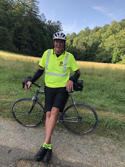
I set out at 6 a.m., just as it gets light, parking outside the beginning of the loop road. The orientation shelter is empty, though you can still buy a Cades Cove Tour pamphlet for a dollar on the honor system. Since I was going to take several hours to walk, I took my daypack with water, snacks and a raincoat. For a glorious 15 minutes, I had the cove to myself. No park staff, no volunteers, no bikers – just me. When the first two bikes come through and were about to pass me, I stopped them and asked if they would take my picture in the empty Cove. What are the chances of this happening ever again?

The author relished a walk through Cades Cove without vehicles.
Horses used for riding during the day romp around free of constraints. They move almost in unison toward the fence. Unlike deer and bear, the horses don’t seem to go over the fence. Are they expecting a handout from me?
The cove has two bailout points, if visitors need to exit before completing the entire loop. Sparks Lane cuts across the cove at about the two-mile point. This road has been part of the cove system since the 1840s. It’s a useful road for drivers stuck in traffic and wanting to leave.
Lots of deer run through the valley, across the road, and into the trees. Turkeys also go under the fence to get to the other side.
A Little History
Though the Cherokees camped and hunted in the cove, they never settled here. The first Europeans to move to the Cove in the 1820s include names that you’ll find in the valley and in eastern Tennessee: Oliver, Tipton, Cables, and Burchfield.
Settlers cleared the land, built log homes, corncribs, mills and smokehouses. Almost everyone in the valley farmed, even if they had other occupations such as blacksmith, storekeeper or coffin- making. And of course, the Cades Cove community built churches. You can still visit three churches: Methodist, Primitive Baptists and Missionary Baptists.
In anticipation of the creation of Great Smoky Mountains National Park, much of the cove land had already been sold to the State of Tennessee and then given to the federal government. Some residents accepted less money to be able to live out their days in Cades Cove. But the school closed in 1944 and the post office three years later.
According to an article in the Knoxville News-Sentinel, the last of the original cove residents, Kermit Caughron, lived in a former one-room schoolhouse about three-fourths of the way around the loop road until shortly before his death in 1999 at age 86.
Bikes And More Bikes
I walk on the grass or gravel on the side of the road, as much as possible. I only stop at one church, mostly to see if it’s open – it is. But I’m more interested in walking than in checking out the buildings. I feel that I’m on a schedule, since the gate is going to open at 10 a.m. for a flood of cars.
At about 7 a.m., I reach the intersection with Hyatt Lane, the second road across the cove. The sign said that I’m at the five-mile point. That would mean that I walked five miles in an hour, faster than on a treadmill. I take that distance with a large grain of salt.
By now, bikers pass me with more frequency. The first riders have helmets, closed-toe shoes and bike clips. They move fast and fluidly, staying well away from me. As time goes on, large family groups swarm the road. They may try to stay together, taking up most of the road width. But they’re spread out, stopping and waiting for each other.
“Hey, wait up,” they yell out behind them.
A large group of cyclists stops at a viewpoint into the valley. They’ve spotted a bear and try to take pictures of what will be a large black dot. That’s no different than bear jams and traffic snarls the rest of the time.
Halfway Point
At about the half-way point, I reach the Cable Mill Historic Area and Visitor Center. Ordinarily, this area is teeming with people watching craft demonstrations, picnicking, and checking out the bookstore.
This morning, the only attraction are the bathrooms. Everything else is closed. It’s about eight o’clock, and two Park Service maintenance trucks come through, mindful of the bikers.
Randall Bradley works as a volunteer with the Cades Cove bike patrol/Danny Bernstein
The second half of the loop never seems as interesting. A few cabins sit almost equidistant to each other. This area may have been the poor side of the cove. No churches or other public buildings have been placed here.
This is where I meet Randall Bradley, a volunteer on the Cades Cove bike patrol. Bradley, from Dandridge, Tennessee, wears a bright yellow jersey, matching socks, and black bike shorts. He’s been volunteering in the cove since the team was created in 2010. He carries a radio and provides assistance to bicyclists riding the Loop Road when the road is closed to vehicle traffic. According to the park website, since the patrol was formed there has been a 50 percent reduction in serious bicycle accidents during these morning closures, despite a 30 percent increase in bicycle use over the same time.
Bradley notices a cyclist going the wrong way on his bike.
“I’ve got to find my wife,” the visitor says.
“You can walk back that way,” Bradley tells him, “but you can’t ride against the bike traffic.”
Like all volunteers, Bradley can’t enforce the rules, but he has a radio, connecting him to a park ranger who can. The biker dismounts reluctantly.
Coming To The End
The south side of the Loop Road is more shaded and has more ups and downs. There are signs to alert cyclists to walk their bikes on sharp downhills. Some do but others just look at the terrain as a more thrilling ride. A few runners have passed me, but I seem to be the only walker this morning.
When I see slow walkers coming toward me, I know that I can’t be too far from the end. One family has spotted another bear. Cyclists ignore the clump of people and zoom on ahead.
At exactly ten o’clock, I finish walking the loop. A line of cars coming from the campground are waiting for the gate to open. When I turn the corner, a second long line from Little River Road has also formed. Volunteers in orange vests direct traffic, so that the two lines merge without mishap.
I was concerned about finishing by 10 a.m., but I realized that I didn’t need to walk that fast. If cars are let in at 10 a.m., they wouldn’t reach me for another hour, at least. I find my car among chatting, coffee-drinking visitors. Another item crossed off my bucket list.

Saddle horses frolic in Cades Cove when not at work/Danny Bernstein


Comments
the only problem with the black bears is usually the people blocking the road to take pictures. I'm sure that there's the occasional dummy that tries to approach them. They are BEARS!! I always remember trying to go by the crowd really fast and like the author says they're taking pictures of a black dot... They're usually out in the morning and evening and its a treat to see one. They usually keep their distance. I don't think bear spray is ever a bad idea when in bear country, but neither is good bear etiquette. You are in their home!
Have had it in my mind to walk that loop for years and this is the year! THANKS so much for the great info!
We just completed the loop today, on foot. It was a little tough for us but we powered through. This Wednesday there are no cars all day so we could take our time. It was well worth it. We saw several bear families, dear, turkeys, etc. I wanted to research others that have walked and happened upon this blog. So great. Thank you!