You are here

Photo Essay: Kīlauea Volcano's Erupting Lower East Rift Zone

Share

Though not explosively dangerous like Mount St. Helens or Krakatoa, the Kīlauea volcano at Hawai'i Volcanoes National Park is a potent cauldron of earth energy in the form of molten magma. The following photos and video taken late last week hint at the volcano's power.

 Pu‘u ‘Ō‘ō cone at Hawai'i Volcanoes National Park/USGS

A view of Pu‘u ‘Ō‘ō's cone at Hawai'i Volcanoes National Park/USGS

the collapse crater in Pu‘u ‘Ō‘ō. This photo looks to the east, and shows the deep collapse crater formed on Monday, April 30, when magma beneath Pu‘u ‘Ō‘ō drained. For scale, the crater is about 250 meters (820 feet) wide.

The collapsed crater in Pu‘u ‘Ō‘ō. This photo looks to the east, and shows the deep collapse crater formed on Monday, April 30, when magma beneath Pu‘u ‘Ō‘ō drained. For scale, the crater is about 250 meters (820 feet) wide/U.S. Geological Survey

New lava fissure on Makamae and Leilani Streets in Leilani Estates subdivision

New lava fissure on Makamae and Leilani Streets in Leilani Estates subdivision photographed early May 4/U.S. Geological Survey

The opening phases of fissure eruptions are dynamic. Additional vents and new lava outbreaks may occur. The fissure in Leilani Estates (as of 6:00 p.m.) was about 150 m (164 yards) long.

The opening phases of fissure eruptions are dynamic. Additional vents and new lava outbreaks may occur. The fissure in Leilani Estates (as of 6:00 p.m.) was about 150 m (164 yards) long/U.S. Geological Survey

Fissure No. 3 at Leilani and Kaupili streets/USGS

Fissure No. 3 at Leilani and Kaupili streets on May 4, 2018/U.S. Geological Survey

This plume arose from Kilauea after a 6.9 magnitude earthquake Friday/USGS

This plume arose from Kilauea after a 6.9 magnitude earthquake Friday/U.S. Geological Society
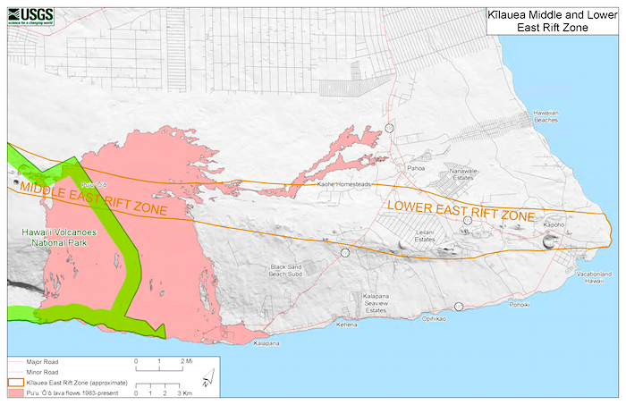
 

Map of Lower East Rift Zone At Hawai'i Volcanoes National Park/USGS

This map depicts the location of the Middle and Lower East Rift Zones at Hawai'i Volcanoes National Park/U.S. Geological Survey

t7:45 a.m. local time Saturday Fissure 8 slow advanced to the northeast on Hookapu Street in Leilani Estates subdivision on Kīlauea Volcano's lower East Rift Zone/USGS

At 7:45 a.m. local time Saturday, Fissure 8 slow advanced to the northeast on Hookapu Street in Leilani Estates subdivision on Kīlauea Volcano's lower East Rift Zone/USGS


Comments

Wow!  The photos and video are really dramatic.  The photo that amazes me the most, though, is the second one:  the collapsed floor in the crater of Pu‘u ‘Ō‘ō.  In 2017, I and a group of other photo tour attendees took an open-door helicopter ride over this very crater, when the crater floor was still present.  Big difference!


Add comment

CAPTCHA

This question is for testing whether or not you are a human visitor and to prevent automated spam submissions.

Image CAPTCHA
Enter the characters shown in the image.

The Essential RVing Guide

The Essential RVing Guide to the National Parks

The National Parks RVing Guide, aka the Essential RVing Guide To The National Parks, is the definitive guide for RVers seeking information on campgrounds in the National Park System where they can park their rigs. It's available for free for both iPhones and Android models.

This app is packed with RVing specific details on more than 250 campgrounds in more than 70 parks.

You'll also find stories about RVing in the parks, some tips if you've just recently turned into an RVer, and some planning suggestions. A bonus that wasn't in the previous eBook or PDF versions of this guide are feeds of Traveler content: you'll find our latest stories as well as our most recent podcasts just a click away.

So whether you have an iPhone or an Android, download this app and start exploring the campgrounds in the National Park System where you can park your rig.