Known as the “Crown of the Continent,” I prefer to think of Glacier National Park as the Crown Jewel of the National Park System. I was born 24 miles away from this setting of pine-, cedar-, and fir-fragrant forests, rugged mountains, glacial U-shaped valleys, abundant wildlife, flower-filled fields, pristine lakes and trail choices suitable for all walks of life.
When I was 9, I rode in the backseat of my father’s Datsun Roadster, my parents having wrapped a quilt around me, as we drove—top down—into the park and over Going-to-the-Sun Road one last time before we moved out of Montana. Of all the memories I have of the Treasure State, this single memory of Glacier is the one I recall with the most clarity. Such is the pull of this national park.

Let’s say you have three days to spend in Glacier. While this park is stunning no matter what season of the year, it’s most popular with visitors during the summer. By late-June or early July the Going-to-the-Sun Road is open in its entirety— barring any snowstorm—most trails are snow-free, wildflowers are blooming, and the wildlife is plentiful.
There are all sorts of lodging options for this national park. Wherever you wish to spend your nights, be it in one or more of the park’s rustic, historic lodges such as Lake McDonald Lodge, Glacier Park Lodge, or the Many Glacier Hotel, a smaller brick-and-mortar option such as Rising Sun Motor Inn or Swiftcurrent Motor Inn, or one of the lodges just outside the park’s boundaries, make sure you reserve a room far ahead (as in, months ahead) of your trip. A year ahead wouldn’t necessarily be too soon.
Of the 13 park campgrounds, most are first come-, first-served, but a few, such as Apgar, St. Mary and Many Glacier campgrounds, have spaces that can be reserved in advance. If you’re planning to camp, familiarize yourself with the camping page on Glacier’s website. On it you’ll find a “campground status” page that keeps daily track of when campgrounds fill. Know that cell phone service is spotty, although you might get a signal at East Glacier, St. Mary, or Apgar.
Prepare for the weather. Summer in Glacier does not necessarily guarantee constant sunny warmth and gentle breezes. Temperatures can change on an hourly basis in the alpine elevations, and you can quickly go from sun to rain to even snow and sleet. Remember to pack a fleece jacket, raincoat, and warm hat next to your T-shirt, shorts, and sunscreen.
Ok. Three days. What should you do?
Day 1
This is a no-brainer: traverse the entire length of Going-to-the-Sun Road, approximately 50 miles end-to-end. Pack water, a lunch or plenty of snacks, and leave early in the morning, preferably from the west end of this east-west road, to give yourself plenty of time to savor the journey.
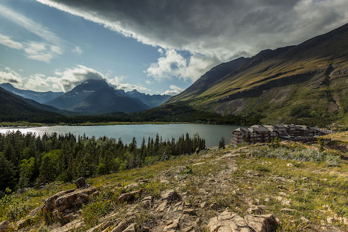
Why start at the west end? Because after you’ve driven this amazing road you’ll continue your excursion to Many Glacier, some 20 miles further north and then west. It will take you approximately two hours just to drive Going-to-the-Sun Road, with a speed limit of 45 mph in the lower elevations and 25 mph in the higher altitudes, and another 30 minutes to reach Many Glacier. Stop at the pullouts and parking areas to take in the views, inhale the fresh mountain air, and listen to the birdsong and burbling water flowing in nearby creeks and streams.
While in Many Glacier, enjoy a refreshment on the Many Glacier Hotel’s back deck as you marvel at the wide-angle views of the mountains looming over Swiftcurrent Lake before continuing your journey to road’s end for a chance to stretch your legs on one of the many trails beginning just beyond the Swiftcurrent Motor Inn.
If you are photographically inclined, this drive is a great reconnaissance trip from which to choose areas for return visits. Two fantastic locations for sunrise shots are the Wild Goose Island view area on St. Mary Lake just west of Rising Sun Motor Inn, and the view of Mounts Gould and Grinnell along the shore of Swiftcurrent Lake in Many Glacier. Use your graduated neutral density (grad ND) filter to keep the brightening horizon from being blown out (overexposed) while you meter for the darker areas not yet lit by the sun.

Day 2
Take a hike. What’s your fitness level and how much energy do you want to expend? Glacier National Park has so many trails of varying lengths and activity levels that a choice might be a little difficult. Decide on one long hike or maybe a couple of shorter ones. To help prepare for your adventure, consider buying either Day Hikes of Glacier National Park Map Guide by Jake Bramante, who has hiked every trail mile in the park, or the Trails Illustrated map to Glacier produced by the folks at National Geographic.
Note: The following hikes are listed in round-trip miles.
Three of the most popular longer hikes are the Highline Trail (15.2 miles), the Grinnell Glacier Trail (11 miles), and the Iceberg Lake Trail (9.7 miles). You can’t go wrong with any of these choices and will be rewarded with views of glacial valleys, mountains, steep drop-offs, turquoise-hued lakes, wildlife from marmots to mountain goats, and meadows filled with wildflowers such as beargrass, Indian paintbrush, and fireweed.
If you don’t feel up for a long hike, then consider something shorter, such as the Avalanche Lake Trail (4.5 miles), the Hidden Lake Nature Trail to the observation platform (3 miles and the most popular hike in the park), the trail to St. Mary Falls (1.7 miles), the Swiftcurrent Lake Nature Trail (2.9 miles), or the Red Rock Falls Trail (4.2 miles). You’ll hike through deep, cool forests and sunlit fields of wildflowers and alongside rushing glacier-fed creeks and waterfalls and possibly spot some wildlife. All of these hikes include magnificent mountain views.
If you choose the Hidden Lake Trail, head out very early in the morning when there are fewer people and to capture sunrise photos of Hidden Lake and Bearhat Mountain at the overlook. A curious mountain goat might even greet you along the way. If you walk the short St. Mary Falls Trail, make sure you carry your circular polarizer or neutral density (ND) filter with you to achieve the “silky water” effect. You might even opt to continue along this trail another mile to Virginia Falls.
No matter which hikes you choose, please obey park rules, don’t feed the wildlife, and stay on the trail. Hiking off trail damages delicate ecosystems of which Glacier National Park is comprised. Also, remember to take plenty of water, a couple of snacks or a sack lunch, a hiking staff and, of course, your camera. Wear a hat and apply sunscreen. Higher elevations mean an increased opportunity for sunburn; even on overcast days (trust me). Don’t forget to make plenty of noise as you hike to alert grizzly bears and other large wildlife of your presence; you also should consider carrying bear spray with you.

Day 3
Make a choice and spend your last day at either Two Medicine or Waterton Lakes (the Canadian portion of Waterton-Glacier International Peace Park).
Once the prime destination of the park during its early days, Two Medicine is now quieter, with fewer sightseers. You might find time to hike the Appistoki Falls Trail (1.2 miles), the Aster Falls Trail (2.4 miles), the Paradise Point Trail (1.4 miles), the Running Eagle Falls Trail (.6 mile) or the Aster Park Overlook (4.0 miles). On the other hand, you may just wish to wander along the shore of Two Medicine Lake, purchasing a snack or the makings for a light lunch at the camp store to eat while enjoying the stunning scenery.
Waterton Lakes National Park is accessed across the Canadian border in the province of Alberta, about 40 minutes north from Glacier’s St. Mary. If you choose to drive here, make certain you have your passport handy.
As you drive north through vast prairieland, stop at the Chief Mountain overlook to gaze and reflect upon this geographic feature considered sacred by the Indigenous Tribes. Continue on to your end destination of a hill overlooking the panoramic scene of Upper Waterton Lake and Waterton Townsite.
Enjoy a meal or a night at the majestic and historic Prince of Wales Hotel. Stretch your legs on the short (0.9 mile one-way) but rather strenuous Bear’s Hump Trail up to an even higher-elevation view of the lake, the town site, and the hotel. You might also wish to take a scenic boat ride to Goat Haunt, at the south end of the lake. It’s a limited port of entry into the United States, so make sure you’re carrying your passport if you wish to hike further south into Glacier.
While three days in Glacier National Park doesn’t seem like much time to explore the trails and photograph the landscapes, you’ll still be amazed at how much you experience. Three days is a great introduction that will whet your appetite for new areas to explore as well as encourage return visits to favorite places the next time you come back to this “crown jewel.”
Stories about:
Story Categories:
A copy of National Parks Traveler's financial statements may be obtained by sending a stamped, self-addressed envelope to: National Parks Traveler, P.O. Box 980452, Park City, Utah 84098. National Parks Traveler was formed in the state of Utah for the purpose of informing and educating about national parks and protected areas.
Residents of the following states may obtain a copy of our financial and additional information as stated below:
- Florida: A COPY OF THE OFFICIAL REGISTRATION AND FINANCIAL INFORMATION FOR NATIONAL PARKS TRAVELER, (REGISTRATION NO. CH 51659), MAY BE OBTAINED FROM THE DIVISION OF CONSUMER SERVICES BY CALLING 800-435-7352 OR VISITING THEIR WEBSITE. REGISTRATION DOES NOT IMPLY ENDORSEMENT, APPROVAL, OR RECOMMENDATION BY THE STATE.
- Georgia: A full and fair description of the programs and financial statement summary of National Parks Traveler is available upon request at the office and phone number indicated above.
- Maryland: Documents and information submitted under the Maryland Solicitations Act are also available, for the cost of postage and copies, from the Secretary of State, State House, Annapolis, MD 21401 (410-974-5534).
- North Carolina: Financial information about this organization and a copy of its license are available from the State Solicitation Licensing Branch at 888-830-4989 or 919-807-2214. The license is not an endorsement by the State.
- Pennsylvania: The official registration and financial information of National Parks Traveler may be obtained from the Pennsylvania Department of State by calling 800-732-0999. Registration does not imply endorsement.
- Virginia: Financial statements are available from the Virginia Department of Agriculture and Consumer Services, 102 Governor Street, Richmond, Virginia 23219.
- Washington: National Parks Traveler is registered with Washington State’s Charities Program as required by law and additional information is available by calling 800-332-4483 or visiting www.sos.wa.gov/charities, or on file at Charities Division, Office of the Secretary of State, State of Washington, Olympia, WA 98504.
Comments
Good article and good advice. I hope to get back here someday. It has been years since my only trip here; but I, and two of my sons, hiked numerous trails for a total of about 60 miles in the few days we had to spend in the area.
Sounds very appealing. But to justify the costs for such a short trip from afar, how about telling the readers from the east coast the best cost effective options to fly close to Glacier park?
I hear you, C. Aviles. I wrote this piece with the mindset of lodging within or near the park as well as deciding what activities to do during a relatively short period of time, like 3 days. However, I can also give a little bit of advice regarding flying into Montana, near the park. The closest you can get is to fly into Kalispell, which is some 34 miles away from Glacier. That's about a 30-minute drive, maybe longer, depending upon how many photo stops you want to make heading into the park - it's all beautiful country along the way, so you'll be tempted. You can also fly into Great Falls, Montana, which may actually be cheaper than flying into Kalispell (it was for me, the one time I did that back in 2009), except that you'll then be driving between 157 - 172 miles, depending upon your route. The drive will take you 2.5 - 3 hours to get there, or longer, because the scenery is gorgeous out that way, as well, with a mixture of plains, mountains and rolling hills perfect for photo ops. In terms of what airline to take - well - that's all up to you and your research. Alaska, Allegiant, Delta and United fly into Kalispell and after a quick online search, it looks like the same airlines fly into the Great Falls airport. Price is always a tricky thing. Sometimes I get a great deal by making my airline reservations months ahead of time. At other times, I can get a better deal waiting to make my reservation anywhere from a month to a couple of weeks prior to my trip. According to my online research, which day you choose to depart also affects ticket price. Tuesdays, Wednesdays and Saturdays are the best days for getting cheaper flights. Flying at dawn or overnight also tend to cost less. I hope this helps you. Good luck with your research.
It truelly is God's country....my family and I can hardly wait to go back.
Thanks R. Latson. I feel lucky to live at the foothills of the Appalachians and near the southern terminus of the AT but a visit out West and to Glacier is very appealing. The information provided will help me determine how much time i can "afford".
Nice article Rebecca.
Questions and comments:
A half-hour to Glacier from Kalispell seems awfully short. Which part?
NPS Rangers lead some of the hikes you mention. Check the NPS website or their newspaper.
Mr./Ms. Aviles: It ain't cheap. In 2010, for 9 days at Many Glacier hotel, flight from Boston, car rental = well over $4,000 for one person (also other expenses). If you live closer, of course, it is cheaper.