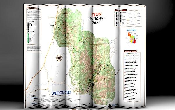
Day Hikes Of Zion National Park folds into a nice, waterproof, portable guide to Zion's day hikes/hike734
You're planning a trip to Zion National Park in Utah, you plan to do some hiking, and you're wondering which trails to search out.
You could pick up a copy of 50 Best Short Hikes In Utah's National Parks, which would be a good start in identifying some hikes in Zion. But a new "map guide" from Jake Bramante, the guy who hiked all 734 miles of Glacier National Park in one year, would be a good investment, too, if you're solely interested in day hiking in the park.
Day Hikes of Zion National Park, which provides details on 29 hikes in the park, is printed on tear-resistant, waterproof paper that folds down to a roughly 4.5-inch by 9-inch brochure that you can stuff in your back pocket or day pack. Unfold it and you find a map of the park with key facilities (restrooms, visitor center, lodging, picnic areas, etc) marked along with numbered hikes. Shuttle bus stops in the park as well as neighboring Springdale also are numbered to help you catch a ride.
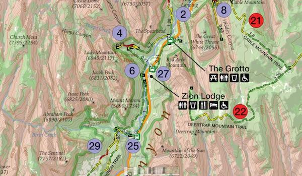
This map is similar to Bramante's Day Hikes Of Glacier National Park. Hikes in the Zion guide are color-coded by region in the park. So if you look at all the purple-coded hikes, you'll know they're in the same general area of the park; in this case, in Zion Canyon. Green circles denote trails on the West Rim, violet is tagged to those on North Creek, yellow indicates southwest desert, light blue is The Narrows, and red is Kolob Canyons and the East Rim. Lines denoting the trails are even color coded: green for easy, yellow for moderate, and red for strenuous.
The map color codes hikes by region, and uses more colors to denote easy, moderate, and strenuous hikes/hike734
A glance at "Jake's Order of Hikes, which lists his favorites in descending order, tells you whether you'll encounter steep cliffs, whether a particular hike is family friendly, and whether the trail is accessible.
On the back of the map you'll find a breakdown of the trails with descriptions. Here Bramante segregated the hikes by distance, so you can quickly identify the mileage so you don't overdo it. You'll also find a box of safety information, ranging from steep cliffs in the park to the need to drink lots of water in this desert setting and even symptoms of heat stroke.
There's even a small box of information on where you can obtain additional books and maps.
If day hiking is your goal, this is a good tool to help you plan, and pull off, your day-long journeys in Zion. You can order a copy at Mr. Bramante's website.


Comments
Let me know next time (1) you run into a ranger in the backcountry, and when you do, (2) ask if she/he has a GPS with her/him and if she'/he's making waypoints, (3) if she/he and her/his buddies do a data dump to create a list of GPS coordinates for individual trails and campsites, and (4) if they pass that list to their webmaster for posting.
Obviously at least one of the answers to your questions is "no". The next logical question is, why not.
Maybe a few possible questions/ answers: (1) How many GPS units are available to backcountry rangers to carry around on a daily basis? (2) Are those units of adequate quality to capture the level of accuracy / detail needed for the project under discussion?; (3) There simply hasn't been enough demonstrated demand for this information to get it done.
Bet you a cup of coffee that if staff time were being spent on this project - and that includes compiling all the field data and putting into some useable form for visitors - somebody would be complaining about the waste of tax dollars on a product that would be provided by the private sector if these was really a need / demand for it.
I'd rate this as one of many "nice to have" projects, but certainly not essential.
Unless those campsites are moving on a "daily basis" not many would be needed. I would think in 1 year, a single unit could be walked down every trail past every campsite in the park.
The typical off the shelf consumer unit can be with in a few feet - so yes.
Neither I nor you know whether that is true though the massive investment in GPS technology and the plethora of sites with GPS data on other hikes would suggest otherwise to me.
A quick search found these resources for GPS waypoints in NW parks:
http://www.wta.org/hiking-info/basics/how-to/how-to-prepare-for-backpack...
The Nat'l Geo maps seem to be more than fifteen, and include Arches, Canyonlands, Carlsbad, Crater Lake, Delaware Water Gap, Everglades, Grand Canyon, Guadalupe Mountains, Hawaii Volcanoes, Lassen, North Cascades, Shenandoah, Smokies, Saguaro, Sequoia-Kings, Tetons, Yellowstone, & Yosemite.
http://shop.nationalgeographic.com/ngs/category/maps/travel-and-hiking-maps
Why not just use Google Earth? I use it all the time to obtain GPS coordinates in all sorts of places. I used it last fall for coordinates in Zion and found them to be almost right on. The work has already been done. All required is a little effort on the part of people who want to use them. In the time spent to complain here, one could have had all sorts of waypoints for Zion and virtually any place else on the planet. At no expense to the government, by the way. Shouldn't Tea Partiers rejoice over that?
Another excellent resource for visiting Zion is a book published by Zion Natural History Association and sold for $17.
ZION ADVENTURE GUIDE - EXPLORING ZION NATIONAL PARK by Greer Chesher. Well worth the dollars spent.
Well first, I don't thing Google Earth has the coordinates for all the backcountry sites in RMNP. If so, please provide the link.
Yes, thousands of people that want the coordinates could research them - as I ultimately did. Or the Park Service could have one person do it and provide the information to thousands of people that would appreciate it.