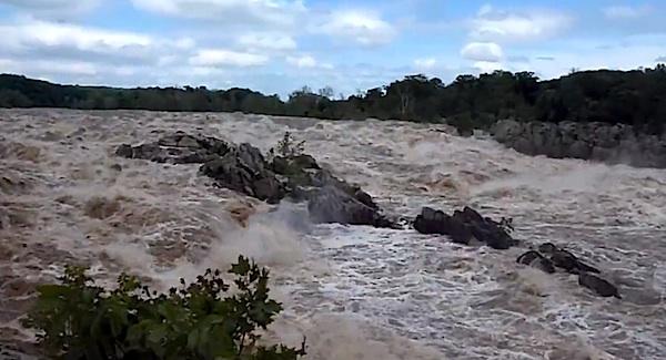
Heavy runoff had the Potomac River running fast and furious Friday at Great Falls Park/NPS
Flooding problems, possible sewage overflows, and downed trees were causing problems Friday for Chesapeake and Ohio Canal National Historical Park, the Appalachian National Scenic Trail, Rock Creek Park, and other National Park System units in and around Washington, D.C., and officials said things could get worse this weekend.
The heavy rains are expected to cause rivers and streams to peak lake Saturday or Sunday, and as a result road, facility and trail closures should be expected throughout the weekend, the Park Service said in a release. Visitors were being urged to check park websites for the most current information, but were also cautioned that "these situations can evolve rapidly and information on specific closures may be delayed. Park visitors who venture out onto trails should expect muddy conditions and puddles."
Park Specific Closures and Contact Information As Of Friday Evening
National Mall & Memorial Parks: Hains Point remains closed. Ohio Drive (along the Potomac River and next to the recreational fields is currently open) but may close if water levels rise as predicted. Ohio Drive (along the Washington Channel, near the East Potomac Park Tennis Center) remains closed. East Potomac Park Golf Course and Tennis Center will likely be closed until water levels recede. Some other low-lying areas of the National Mall, including a portion of Independence Avenue, may be closed if water levels rise as predicted. In anticipation, some permitted events including the BKB Foundation and Children's Fund foot-races are canceled.
Rock Creek Park: Park visitors should expect downed trees and various debris along trails and roads. Rock Creek Parkway and Beach Drive may experience closures this weekend during periods of high water.
Chesapeake & Ohio Canal National Historical Park: Several closures are in place and low-lying areas of the canal towpath may close if water levels rise as predicted. Current closures are: Capital Crescent Trail between Fletcher's Boathouse and Water Street including the Foundry Branch Tunnel (due to possible sewage overflow), entrance road to Great Falls Tavern Visitor Center, Olmsted Overlook, Billy Goat Trail, 15 Mile Creek Campground, and the Appalachian Trail Bridge over the Potomac River. The following boat ramps are closed: Big Slackwater, Taylors Landing, Snyder Landing, Nolands Ferry, Monocacy, Edwards Ferry, Lander, Brunswick and Point of Rocks.
George Washington Memorial Parkway: Drivers may experience lane closures during periods of high water especially around Memorial Bridge.www.nps.gov/gwmp
Great Falls Park: In Maryland- the park is closed to vehicle access. In Virginia- visitors may experience some trail closures during periods of high water. If water levels rise more than predicted the park will close.
Harpers Ferry National Historical Park: The park has evacuated several offices and historic buildings along Shenandoah Street. Hikers should be prepared for the Appalachian Trail to be closed near Harpers Ferry and Lock 33 of the C&O Canal.
Monocacy National Battlefield: The following are closed: Worthington Ford Trail, Middle Ford Ferry Trail and Gambrill Mill Trail and boardwalk. Visitors should also expect a closure of the Brook Hill trail. Other park trails are muddy.
As for that possible sewage overflow, the Park Service said that DC Water was investigating a possible Sanitary Sewer Overflow (SSO) overnight in C & O Canal National Historical Park.
"An SSO occurs when diluted untreated wastewater spills or overflows, and can be caused by excessive rainfall," the Park Service said. "Due to the overflow, the Capital Crescent Trail is closed to the public between Water Street in Georgetown and Fletcher's Cove. The National Park Service recommends using the C&O Canal Tow Path as an alternate route in this location, but cautions that portions of the Tow Path prone to flooding may be closed farther upstream. Water levels are expected to peak Saturday afternoon."
The following areas along the canal were closed due to high water:
* Big Slackwater Boat Ramp
* Taylors Landing Boat Ramp
* Snyders Landing Boat Ramp
* Nolands Ferry Boat Ramp
* Monocacy Boat Ramp
* Edwards Ferry Boat Ramp
* Lander Boat Ramp
* Brunswick Boat Ramp
* Great Falls Entrance Road
* Appalachian Trail Bridge over the Potomac River
* Point of Rocks Boat Ramp

 Support Essential Coverage of Essential Places


