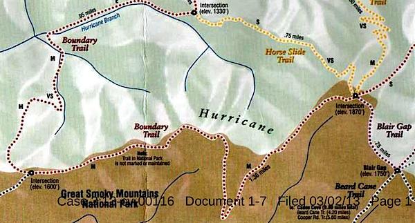
This map, said to have come from Blackberry Farm Resort, shows two trails -- the Boundary Trail and the Blair Gap Trail -- that are not listed on Great Smoky Mountains National Park's official trail map/Southern Forest Watch
Sometime in recent years two trails running more than a mile-and-a-half were cut into the backcountry of Great Smoky Mountains National Park, allegedly for the use of a private resort that borders the park, according to court documents.
When contacted by the Traveler, park officials declined to discuss the trails, or even acknowledge their existence, as their presence has been raised in litigation. However, the "Boundary Trail" and "Blair Gap Trail" depicted on a trail map purportedly handed out by the Blackberry Farm Resort do not match any trails on the park's official trail map. Together they run along the park's western boundary roughly from the Beard Cane Trail to the Cane Creek Trail. Officials at the resort, where rooms start at $745 a night, had no immediate comment when asked about the trails this week.
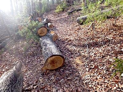
A trail of downed trees allegedly marked an illegal trail cut in Great Smoky Mountains National Park/Southern Forest Watch
The existence of the trails surfaced in connection with a lawsuit brought against the Park Service by Southern Forest Watch, a nonprofit group organized to overturn the park's $4 per night fee charged on backcountry travelers. Though not central to the fight over the backcountry reservation system, the group pointed to the "illegal trail system" as part of a pattern of "political patronage" that former park Superintendent Dale Ditmanson oversaw. Mr. Ditmanson, who instituted the backcountry fee system in 2013, retired from the Park Service earlier this year.
By allowing the Blackberry Farm Resort to maintain these trails for the use of their customers and residents, Great Smoky Mountains officials were limiting the general public's access to the park's backcountry and allowing it to be impaired, charges Southern Forest Watch's lawsuit.
The Park Service, in court documents responding to Southern Forest Watch's complaint, denied allowing a "private resort to maintain and utilize their own separate, exclusive network of trails into, on and within the boundaries" of the park. However the agency did admit that there was a signpost with a map box located outside the park boundary and that "any signs that were erected within Park boundaries by Blackberry Farm Resort were erected without permission from NPS and have since been removed."
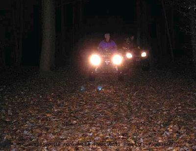
These ATVers allegedly were entering Great Smoky Mountains National Park from the Cane Creek Trailhead/Southern Forest Watch
The trail map showing the Boundary and Blair Gap trails came from the map box on the signpost, according to Southern Forest Watch's lawyer.
The trail signs and maps were found by John Quillen, a member of Southern Forest Watch. A park volunteer who regularly hikes the Cane Creek Trail to help maintain it, Mr. Quillen discovered the Boundary Trail in 2009 when he came upon a trail of trees that had been chainsawed down. He and some friends also heard a chainsaw at work, and encountered riders on two all-terrain vehicles who allegedly claimed they had come from Blackberry Farm. Photos of a trail sign, the ATV, and downed trees are part of Southern Forest Watch's court filing.
No court date for the matter has been set.


Comments
Which waypoint does that?
Yes, thru hiker restock every 5 days or so. Other than the first leg to The Walasi-Yi Center when hiker don't know any better, even with a full resupply for the next 5+days, packs are generally under 45lbs - as the ATC info indicated. I know, I thru hiked. Have you?
The waypoint connected to IMG_2585.JPG.
I have hiked a majority of the AT in the smokies, but I never thru-hiked the entire AT. I haven't had the time yet to take that many months off, in my career. I think if I ever did any of them, i'd prefer the Continental Divide trail. I don't think i've carried a pack lighter than 55 lbs on any multi-day adventures... all that film and photo gear adds up.
Huh? What are you talking about? Seriously, Eric, I'm not trying to argue with you in this thread. So, that comments a little weird...
Gary, you may pack more than 55 lbs for your short jaunts but to claim thru hikers carry the same And chastize a hiker that doesnt is just wrong. Will check the waypoint.
So Gary, where did you pick up the waypoint data?
Talk about going out of your way NOT to go check something out for yourself, I think Gary has taken the cake on this one. But for everyone else, I will make this simple. Here is link to a picture that shows the blackberry farms trail sign is clearly within the NPS boundary. And anyone who wishes can go see where the pole was and the trails remain and the trees are cut. Or we can sit here and listen to someone who can't seem to find the time to see for himself but is so certain everyone is lying about this thing he hasn't had time to go and see. But please go on about pack weights and the AT, something else you haven't found time to do but at which you are also an expert.
http://www.southernhighlanders.com/smallblackberry%20farm%20is%20on%20pa...
And of course it is so frivolous that the NPS admitted that Blackberry had trail sign on park propery and made them remove it. Multiple witnesses with affadavits, photographic evidence and NPS admissions versus a guy who has never been there referencing Lord knows what kind of data that proves nothing. I don't blame you for not going up there to see for yourself, Gary. How would you ever be able to refute the obvious truth that dozens, including another on this forum, have documented?
Please, the management is growing weary of reminding folks not to make personal attacks.