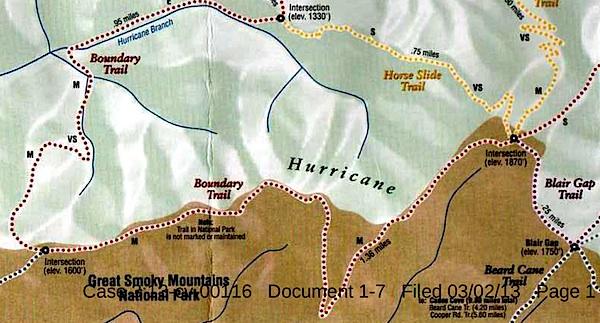
This map, said to have come from Blackberry Farm Resort, shows two trails -- the Boundary Trail and the Blair Gap Trail -- that are not listed on Great Smoky Mountains National Park's official trail map/Southern Forest Watch
Sometime in recent years two trails running more than a mile-and-a-half were cut into the backcountry of Great Smoky Mountains National Park, allegedly for the use of a private resort that borders the park, according to court documents.
When contacted by the Traveler, park officials declined to discuss the trails, or even acknowledge their existence, as their presence has been raised in litigation. However, the "Boundary Trail" and "Blair Gap Trail" depicted on a trail map purportedly handed out by the Blackberry Farm Resort do not match any trails on the park's official trail map. Together they run along the park's western boundary roughly from the Beard Cane Trail to the Cane Creek Trail. Officials at the resort, where rooms start at $745 a night, had no immediate comment when asked about the trails this week.
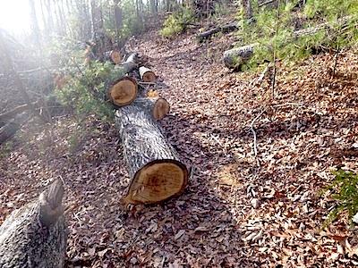
A trail of downed trees allegedly marked an illegal trail cut in Great Smoky Mountains National Park/Southern Forest Watch
The existence of the trails surfaced in connection with a lawsuit brought against the Park Service by Southern Forest Watch, a nonprofit group organized to overturn the park's $4 per night fee charged on backcountry travelers. Though not central to the fight over the backcountry reservation system, the group pointed to the "illegal trail system" as part of a pattern of "political patronage" that former park Superintendent Dale Ditmanson oversaw. Mr. Ditmanson, who instituted the backcountry fee system in 2013, retired from the Park Service earlier this year.
By allowing the Blackberry Farm Resort to maintain these trails for the use of their customers and residents, Great Smoky Mountains officials were limiting the general public's access to the park's backcountry and allowing it to be impaired, charges Southern Forest Watch's lawsuit.
The Park Service, in court documents responding to Southern Forest Watch's complaint, denied allowing a "private resort to maintain and utilize their own separate, exclusive network of trails into, on and within the boundaries" of the park. However the agency did admit that there was a signpost with a map box located outside the park boundary and that "any signs that were erected within Park boundaries by Blackberry Farm Resort were erected without permission from NPS and have since been removed."
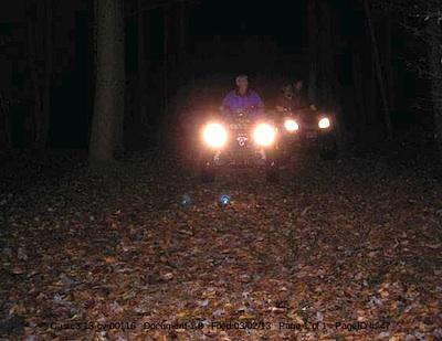
These ATVers allegedly were entering Great Smoky Mountains National Park from the Cane Creek Trailhead/Southern Forest Watch
The trail map showing the Boundary and Blair Gap trails came from the map box on the signpost, according to Southern Forest Watch's lawyer.
The trail signs and maps were found by John Quillen, a member of Southern Forest Watch. A park volunteer who regularly hikes the Cane Creek Trail to help maintain it, Mr. Quillen discovered the Boundary Trail in 2009 when he came upon a trail of trees that had been chainsawed down. He and some friends also heard a chainsaw at work, and encountered riders on two all-terrain vehicles who allegedly claimed they had come from Blackberry Farm. Photos of a trail sign, the ATV, and downed trees are part of Southern Forest Watch's court filing.
No court date for the matter has been set.


Comments
Ok, so there are a lot of unnamed manways/former trails, many still in use, inside the park. Does that make it ok for private entities to maintain them? A simple visit to these trails would quickly prove or disprove someone is maintaining them. And use of chainsaws on these manways or private trails or whatever you want to call them would be plainly evident, too. If they are found to be well maintained, who is maintaing them? NPS can't even keep up with the blowdowns on official trails. Why would NPS clear damage for a trail that it no longer recognizes as official trail? Who puts out a professionally printed map showing trails inside the boundary that the NPS hasn't recognized in over 40 years? Whole thing smells fishy to me.
I can tell a lot of you guys are urbans, and never lived near public lands, including the accusers. It's very painfully evident. I have lived next to public lands for a long time starting in the west, in one of the most remote parts of the lower 48. We were surrounded by public lands, and we hiked the trails, even if the USFS didn't maintain them there were connector trails to maintained trails. This is common place. We would mountain climb up what they called "goat trails" or "climber trails"..
When I first moved to the Smokies, I lived close to the park. I don't anymore, but back when I moved to this area, I was within a half mile of the park boundary while living in Gatlinburg. I hiked Cove Mountain trail a lot with my family. We would hike it about every so often and I accessed it from an existing manway that wasn't too far from my house. I knew two other people that would occasionally walk this trail and i'd see them every once in a while. Of course, living next to the park, you sort of know where to access the park trail. Everyone that I knew was respectful, and just liked to walk it. It's part of the "Mountain Tax" benefits, fellows.
Let's say you have a property next to a public land. There is an existing old trail. Your land butts up to that old trail. You use that trail from that property, is that against the law? No. Our public lands are filled with these trails. A branch falls on the trail, and you push it to the side, is that against the law? If you're walking this trail quite a bit, you're going to keep the vegetation from growing on it. These manways have existed for a long time. These properties have been owned for a long time. Manways are all over the border near these private lands...they have been there a long time.
Regardless, even on Cove Mountain, I never saw anyone put an ATV on that trail. I don't live there now, but when I did I never saw illegal activity, even during bear hunting season. You guys want to know who also uses these trails? Wildlife! That's right. Wildlife. Bears, turkeys, deer, racoons... You name it.
What's your solutions fellows? Wall off all private lands from public lands? Is that your solution? Is that what you guys want? I can't recall seeing any fences around the Smokies and i'd cringe to see that. If you're just going to rail against Blackberry Farms just because Alexander had ties to it at one time, you have a few thousand more property owners, and many more manways next to the park to get to, that all have "evil residents" that might walk into the park from their land. Good luck!
Looks like Gary is slipping from denial to moral relevance.
Gary Wilson is correct, this is an historic trail. The 1941 USGS Kinzey Springs topographic map is available for free download at http://ims.er.usgs.gov/gda_services/download?item_id=5335412 It clearly depicts the CCC-era Boundary Trail, including its Blair Gap segment, and extending far beyond both east and west.
If GSMNP ever documented its CCC-era trail system, built and improved in the years immediately following the Park's 1934 dedication by FDR, I am confident it would be eligible for listing in the National Register of Historic Places as an Historic Landscape. It would include this trail segment along Hurricane Mountain. The Park would then be required under NHPA to plan either its preservation through maintenance or its destruction through continued neglect.
Meanwhile, I'm glad others share respect for our heritage and have preserved it. Trails are built to be used, and the best way to honor them is to use and maintain them.
Either you're for that, or you're against it. All the rest of the the innuendo and conspiracy theories posited above strike me as being either irrelevant or sheer nonsense. Keeping this trail alive is a public service. Walking and riding horses on trails is source and the continued reason for the existence of our wilderness National Parks.
Rodf, an interesting post. For me, the issue of reopening a trail is a worthy effort, I agree with you on that. But, like so many issues, hoops must be jumped through, primarily the park has the responsibility to identify the project and then if authorization is needed, NEPA compliance or some permitting process is required. I think the NPS does a disservice when they are not transparent on these issues, I think that is all that is needed here to answer the questions. I do not agree that this controversy is irrelevant, the parks face an enormous amount of requests from user groups to open or build more trails (one recent example was the Half Dome Cables issue where it was proposed to just build a second cable to handle the demand to do the climb), so a public interest is at stake here. If the process is correctly followed, and if I understand NEPA correctly, I have no issue with that decision, weather I agree with it or not.
Agreed rmackie. Its not up to "others" to decide they want a trail reopened and it certainly isn't appropriate for the NPS to pretend it isn't happening.
Thanks Rod, that shows the route of the old CCC trail on an old 1940 USGS topo. That is perfect and is exactly what ive been saying all along. Had to step through countless arrows being slung and many conspiracies and barbs, but that's expected from John Quillen. What can you expect from a group that uses a blindfolded owl with only 1/2 of it's two eyes open as their main logo? I think that's a fitting logo for how they act.
You do bring up an interesting point about having these old CCC trails designated on the National Register of Historic Places. Very interesting thought and thanks for the input!
Also, this link below has some input from a person that witnessed the incident involving the 4 wheeler on Cane Creek. This was described and witnessed as a one time incident. This was the result of a search and rescue operation, and the person on the four wheeler later chimes in on the thread, and admits it was for that. So, that again proves that the accusations of "backdoor deals with ATV's that are rummaging over Cane Creek and the boundary trails" are just that - trumped up accusations. http://www.whiteblaze.net/forum/showthread.php?104117-New-%28illegal%29-...!
Thanks again, Rod! And keep it going in the Olympics. Amazing place you protect out there.
rmackie, many manway trails in the Smokies are hiked quite a bit. The part of this manway that has fallen apart and overgrown is more than likely the part of the trail that was abandoned, which is from Cane Creek. I said in an earlier post, that I have my extreme doubts 4 wheelers could make it up along this ridge, and this is the section that is overgrown. And my assumptions were not incorrect.
The rest of this trail was probably in good shape. The CCC built a lot of things to last. Point is, blackberry farms has been in existence for a long time. Well before Lamar Alexander was a part of it. That map that Rod posted is kind of interesting if you know the terrain, because most of that area is now developed with roads, and creeping mcmansions that follow the ridgelines up to the border. Many more houses are slated to be developed here. Interestingly one of the few large tracts that is still undeveloped is the property that is a part of Blackberry Farms. The farm was started in 1939... interestingly, the same time the CCC was building these trails.
The allegations on this page were that Blackberry Farms cut a new trail system into the park. Those allegations are false. This 1940 USGS map shows that if you look at the map posted above. It's the exact same trail.