
A recent project involving remote imaging technology helped preserve, photographically, prehistoric trackways at White Sands National Monument. NPS photos.
In the shifting sands of White Sands National Monument, traces of the prehistoric past are slowly being erased. Though they might soon be gone, these markers left behind by mammoths and camel-like animals have been preserved through remote imaging technology.
The project, a collaboration between the National Park Service, U.S. Bureau of Land Management, U.S. Geological Society, and even the Defense Department, relied in part on a drone for some of the photography.
The area of study included a portion of a Late Pleistocene megatracksite within and around the national monument. Thousands of 'Ice Age' fossil vertebrate tracks and trackways that date to approximately 20,000 years ago have been documented within the White Sands megatracksite, according to researchers.
The trace fossil assemblage is dominated by proboscidean (mammoth) footprints along with associated camelid (camel-like), undetermined artiodactyl, and large and small carnivore tracks. These fossil tracks are preserved in soft gypsiferous lacustrine and playa lake margin sediments which are extremely fragile, ephemeral, and weather rapidly once exposed.
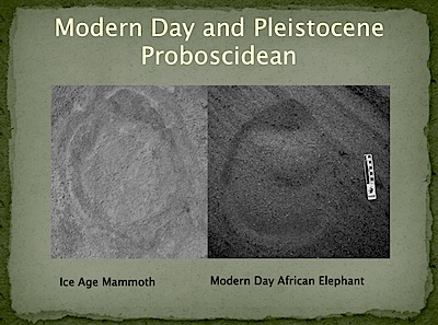
Photo of modern-day African elephant track by Mike Pasenko.
Finding fossilized tracks in the monument's sandscape isn't unusual. Park Service staff say monitoring of the fossil tracks preserved within the monument "continuously reveals new fossil track occurrences, as well as documents the rapid deterioration of previously recorded fossil tracks."
While researchers can use hand-held high-resolution cameras to document and monitor these sites, the need to get so close to the trackways for the photography can lead to some ground disturbance, and also leave human tracks close to the fossilized ones.
"This potentially leads to overprinting of fossil tracks and damaging some fossil tracks not initially identified by the photographer on the ground," said David Bustos, a biologist at the monument. "In an effort to document the large number and diversity of fragile fossil tracks preserved over an extensive geographic area, an interagency team was assembled to support this project. Paleontologists, resource managers and aviation specialists from the NPS, BLM, USGS and the State of New Mexico worked with the staff at White Sands National Monument in a multi-month project planning effort to support the paleontological field work."
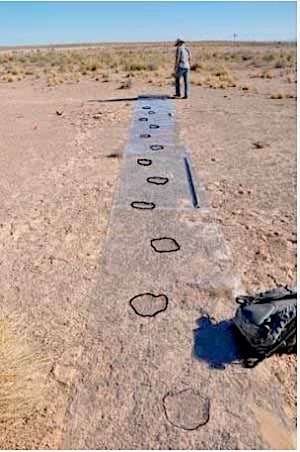
This shot was taken while a researcher was collecting metric data on a camelid trackway. A clear sheet of Mylar was overlaid the trackway so the tracks could be outlined for clarity. NPS photo.
The Department of Defense provided high-resolution satellite imagery for the project, while the BLM used a drone -- an RQ-16 Tarantula-Hawk (T-Hawk) ' for additional photography.
"The aerial photography and videography enabled centimeter resolution and geospatial data collection while minimizing impacts and ground disturbances to the fragile paleontological resources. Additionally, use of the T-Hawk Platform represented a significant time savings by covering larger geographic areas and reducing the need for in-depth field reconnaissance," noted Mr. Bustos. "Resource protection is also a consideration as the use of the T-Hawk for aerial photogrammetry enabled data to be captured from the air without threatening the tracks through ground disturbances caused by foot traffic."
But in addition to the satellite and aerial imagery, researchers were able to identify and photograph "six of the most unique and best preserved trackways" through the use of "ground base photogrammetry" that, in effect, was similar to laser scanning the trackways.
"The extreme precision of the ground base photogrammetry will allow the tracks to be studied long after they have weathered away and enable the creation of exact 3-D replica models to be produced for future generations to enjoy and study," said Mr. Bustos. "The 3-D models will allow millions to enjoy the tracks virtually or in person with no resource damage, truly leaving no trace and protecting the actual location of sensitive fossil localities."
Story Categories:
A copy of National Parks Traveler's financial statements may be obtained by sending a stamped, self-addressed envelope to: National Parks Traveler, P.O. Box 980452, Park City, Utah 84098. National Parks Traveler was formed in the state of Utah for the purpose of informing and educating about national parks and protected areas.
Residents of the following states may obtain a copy of our financial and additional information as stated below:
- Florida: A COPY OF THE OFFICIAL REGISTRATION AND FINANCIAL INFORMATION FOR NATIONAL PARKS TRAVELER, (REGISTRATION NO. CH 51659), MAY BE OBTAINED FROM THE DIVISION OF CONSUMER SERVICES BY CALLING 800-435-7352 OR VISITING THEIR WEBSITE. REGISTRATION DOES NOT IMPLY ENDORSEMENT, APPROVAL, OR RECOMMENDATION BY THE STATE.
- Georgia: A full and fair description of the programs and financial statement summary of National Parks Traveler is available upon request at the office and phone number indicated above.
- Maryland: Documents and information submitted under the Maryland Solicitations Act are also available, for the cost of postage and copies, from the Secretary of State, State House, Annapolis, MD 21401 (410-974-5534).
- North Carolina: Financial information about this organization and a copy of its license are available from the State Solicitation Licensing Branch at 888-830-4989 or 919-807-2214. The license is not an endorsement by the State.
- Pennsylvania: The official registration and financial information of National Parks Traveler may be obtained from the Pennsylvania Department of State by calling 800-732-0999. Registration does not imply endorsement.
- Virginia: Financial statements are available from the Virginia Department of Agriculture and Consumer Services, 102 Governor Street, Richmond, Virginia 23219.
- Washington: National Parks Traveler is registered with Washington State’s Charities Program as required by law and additional information is available by calling 800-332-4483 or visiting www.sos.wa.gov/charities, or on file at Charities Division, Office of the Secretary of State, State of Washington, Olympia, WA 98504.

Comments
Great work! Are the preliminary results available for review?