Visitors to Cape Hatteras National Seashore soon will have 29 new access points for exploring the seashore's beaches under a plan stemming from its off-road vehicle management plan.
The projects, ranging from parking lots and off-road vehicle ramps to handicap accessible boardwalks, were outlined in the seashore's Construction of New Development that Facilities Public Access Environment Assessment. After nearly two years of planning, the project list was approved in mid-November by the National Park Service's Southeast Region office.
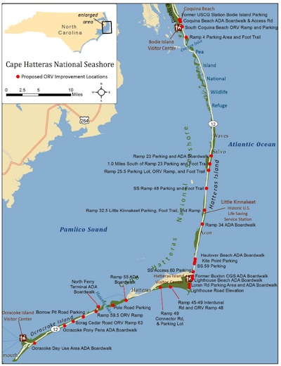
The new access areas will create or improve 15 parking areas, 1 paved and 2 unpaved roads, 5 off-road vehicle ramps, 5 foot paths, 11 accessible boardwalks, and the elevation of an existing flood-prone road section. These access improvements will facilitate ORV and pedestrian access to areas of the Seashore and increase access for visitors with disabilities while minimizing conflicts between a wide variety of recreational users in the seashore, park officials said in a release.
The improved access points will protect the seashore's natural, cultural, scenic and aesthetic aspects as well as address mutual concerns with local communities and governments who expressed concerns about potential safety issues with road shoulder parking along NC Hwy 12.
Map of new access points to be developed. NPS graphic.
The projects:
* A 10-car parking at the former site of the U.S. Coast Guard Station on Bodie Island
* A handicap accessible boardwalk at Coquina Beach on Bodie Island
* Additional access road from NC-12 to fee station at Coquina Beach
* An ORV ramp and 10-car parking area 0.5 miles south of Coquina Beach (New Ramp 2.5)
* A 10-car parking area with foot trail to Bodie Island Spit at Ramp 4
* A 20-car parking area and handicap accessible boardwalk at Ramp 23 (Salvo)
* A 10-car parking area about 1.0 mile south of Ramp 23 with foot trail to the beach
* An ORV Ramp 25.5 with foot trail or boardwalk to the beach
* A 5-car parking area and foot trail to beach (beachside) at soundside Ramp 48
* An ORV Ramp 32.5 (Little Kinnakeet) with a 10-car parking area and foot trail to the beach
* A handicap accessible boardwalk at Ramp 34
* A handicap accessible boardwalk to sound at Haulover Beach Parking Area
* A 15-car parking area west side of highway at/near Kite Point
* A 15-car parking area at soundside access #59 with foot trail from highway to beach
* A 5-car parking area west side of highway at/near soundside access 60
* A 50-car parking area at the former Buxton Coast Guard Station with handicap accessible boardwalk
* A handicap accessible boardwalk at Lighthouse Beach
* A 3-car parking area at Loran Road w/ new handicap accessible boardwalk to the beach
* An elevated section of Lighthouse Rd to address flooding at ramps 43 and 44
* An unpaved IDR between Ramp 45 and 49 w/new ORV Ramp 48 to the beach (Ramp has been moved from 47.5 to 48)
* Widen Ramp 49 and add connector road and 5 car parking area to Billy Mitchell Rd. near Frisco Campground
* A handicap accessible boardwalk at the Ramp 55 parking area on Hatteras Island
* An unimproved 20-car parking area near the Pole Road/Spur Road intersection
* A handicap accessible boardwalk at/near north ferry terminal parking area on Ocracoke * An ORV Ramp 59.5 at north Ocracoke
* A 5-car parking area at the west side of highway entrance of Borrow Pit Road
* An ORV Ramp 63 across from Scrag Cedar Road
* A handicap accessible boardwalk at the Ocracoke Pony Pens
* A handicap accessible boardwalk at the Ocracoke Day Use Area


Comments
Buxton, in those 40 years have you ever been to the nothern part of Hatteras Island? There is a 13 mile stretch of the seashore that hasn't had ORV on it since 1977. The wife and I enjoy walking there a lot, you should try it sometime. You also may not be aware that beaches in front of the villages are seasonally closed to ORVs for as long as I can remember. You should also be aware that there are other stretches of beach within the park that have been off limits to ORVs for a long time but I know that these are inconvenient truths.
When we stay in Avon and want to enjoy an inlet beach experience we have to drive 15+ miles to get there. If we wanted a no vehicle beach experience we drove 10+ miles to that northern part beause it is our favorite.
Almost all National Seashores allow ORV access to the beach, it's an accepted mode of travel with national parks. Those tire tracks in the sand are erased every tide and storm, you should try low tide.
I aware of only two groups that actively lobby for access to the beaches. I became a donator/member of OBPA shortly after the event I witnessed in 2005. I was not appalled that the beach was closed, but was with the line hundred yard line of barricades and NPS in bullet proof vests and assault rifles. This was upsetting and led to my learning about that organization. Thier motto since it's inception in 70s is "Preserve and Protect Not Prohibit". I still donate every year, but calling them politically powerful is laughable. They don't stand a chance against the dark side. They have been able to do little if anything, unlike the really politically powerful groups like Audubon and DOW.
The park has been maintaining pedestrian access for years also. What is your point?
I don't see walking mentioned or gauranteed in the EL either...
Rmackie, dirt bikes and dune buggies have never been allowed at CHNSRA. The new management plan prohibits camping, beach fires, kite flying and dogs off leash. I suspect that the ORV crowd at CHNSRA is much more respectful of the beach then out there.
Lee, I have always been in favor of the ORV permit and few other ORV regs, thought it would reduce the 2 wheel drives always stuck on the ramps...
Beachdumb, I must tell you I know little about Cape Hatteras. I have never had the opportunity to get there. Your post does make some points, particularly the one on no camping on the beach. I must admit I am a firm believer in campsites, if you or other posters on this website have more information on the issue, it would be interesting to me. The single biggest issue in the almost 15 years of controversy over post 1997 Yosemite flood recovery planing efforts in Yosemite, when the litigation began, was the NPS decision to remove 500 plus campsites from Yosemite Valley while at the same time proposing 500 new motel/hotel units to be constructed in their place. I would like to know more, but if you are correct, I am with you on that issue. Yes, at Pismo Beach State Park, the motor homes do not present the problem, in my own experience, that the the other ORVs do, unless they bring with them all the dune buggies, etc.
Ron, unless there's been a change, camping is allowed at Cape Hatteras, there are four NPS campgrounds, including some that offer sites among the dunes.
http://www.nps.gov/caha/planyourvisit/campgrounds.htm
Now, they don't let you just go to any other beach and camp, so perhaps that's what Beachdumb was referring to.
It seems to me the new rules and fees in Hatteras are in line with the rules at Assateague.
Except for the carrying capacity. At Assateague, the ORVs allowed is limited to 145 at any given time or about 12 per mile. In Hatteras, the density allowed is one per 20 feet of road mile. Hatteras allows more per mile than Assateague allows on the entire beach. Honestly, I see nothing attractive in spending the day in a cross between a parking lot, rush hour traffic, and combat fishing, even if it is on a beautiful beach.
Beachdumb, Almost all National Seashores allow ORV use without limits and permits? Cape Code requires a permit and has use limits and vehicle free areas, same at Assateague. Gulf Islands, no ORV use. No ORV use at Cape Canaveral. Fire Island has extensive vehicle free areas. Point Reyes has no ORV use. Cape Lookout and Padre Island have the fewest limitations on ORV's but due to the remoteness and the limited access to each of those they also do not have the use levels that existed at Cape Cod, Assateage and Hatteras. That is far from almost all National Seashores.
In a post yesterday, beachdumb mentions several examples of areas at Cape Hatteras that are closed to ORV use, suggesting that those areas should be adequate to satisfy users who want to enjoy a beach visit free from vehicle traffic.
If that's the case, one has to wonder why, in similar fashion, ORV users should not be equally satisfied with the areas of the park that are open to that type of use.
There are lots of competing interest groups and types of users at this park, and complicating the whole equation are requirements imposed on park management by court decisions. Under such circumstances, it is nigh onto impossible to please everyone.
This is a large park, with opportunities for a wide variety of activities - and some are not compatible with others. The park has taken a "zoning" approach to try to accommodate various mandates and interests, but some like beachdumb will likely never be satisfied with anything short of elimination of all limits on their favored activities.
Kurt, yes that is what I referring to. Although, the once popular Cape Point campground has been removed from registration system, reduced open times, and through continued mismanagement allowed to be constantly flooded. Also, because of the new excessive closures, the beaches bordering the campground are not accessible to pedestrians or ORVs most the now limited time it's open. It's been virtually empty the past several years...
Mtnliving, your assumption is wrong. I have always been in favor of a permit, and could accept seasonal closures of some of the now VFAs. What I have exception with is the size of the closures and closures for non-threatened and non-endangered species. And these closures prevent pedestrian access as well.
As far as I know, everyone, except enviros, accepted and approved the rules/regs in the 2007 plan. What we have now went way to far and the majority of visitors are not happy with it, hence the strong community disapproval, governors disapproval, and bills in congress to change or remove this new MP. It's not just ORV people that are unhappy...
Bottom line is most these changes would not necessary if the new MP had not made so many areas inaccessible by ORV.
Old Ranger, I never said ORV access without limits or permits. ORV access on CHNSRA has been regulated for as long as I know. There have been designated ramps, trails, speed limits, resource and safety closures, etc. Many falsely believe the NPS did nothing before this new MP plan and allowed unchecked ORV use but that is it not true. They were using a MP that was technically not approved, simply because it had not put into the Federal Register. The story was it was lost in the beauracracy at the NPS Atlanta office, and they failed for years to follow up, thus opening the door for law the suits.