Visitors to Cape Hatteras National Seashore soon will have 29 new access points for exploring the seashore's beaches under a plan stemming from its off-road vehicle management plan.
The projects, ranging from parking lots and off-road vehicle ramps to handicap accessible boardwalks, were outlined in the seashore's Construction of New Development that Facilities Public Access Environment Assessment. After nearly two years of planning, the project list was approved in mid-November by the National Park Service's Southeast Region office.
The new access areas will create or improve 15 parking areas, 1 paved and 2 unpaved roads, 5 off-road vehicle ramps, 5 foot paths, 11 accessible boardwalks, and the elevation of an existing flood-prone road section. These access improvements will facilitate ORV and pedestrian access to areas of the Seashore and increase access for visitors with disabilities while minimizing conflicts between a wide variety of recreational users in the seashore, park officials said in a release.
The improved access points will protect the seashore's natural, cultural, scenic and aesthetic aspects as well as address mutual concerns with local communities and governments who expressed concerns about potential safety issues with road shoulder parking along NC Hwy 12.
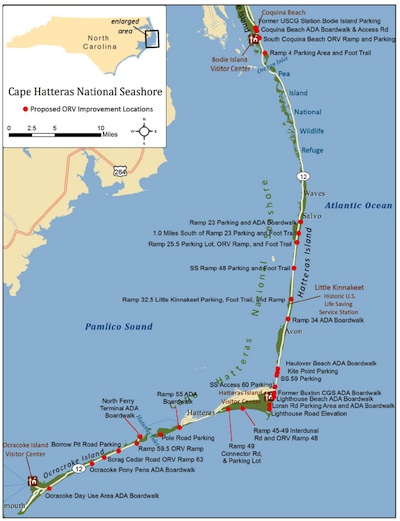
Map of new access points to be developed. NPS graphic.
The projects:
* A 10-car parking at the former site of the U.S. Coast Guard Station on Bodie Island
* A handicap accessible boardwalk at Coquina Beach on Bodie Island
* Additional access road from NC-12 to fee station at Coquina Beach
* An ORV ramp and 10-car parking area 0.5 miles south of Coquina Beach (New Ramp 2.5)
* A 10-car parking area with foot trail to Bodie Island Spit at Ramp 4
* A 20-car parking area and handicap accessible boardwalk at Ramp 23 (Salvo)
* A 10-car parking area about 1.0 mile south of Ramp 23 with foot trail to the beach
* An ORV Ramp 25.5 with foot trail or boardwalk to the beach
* A 5-car parking area and foot trail to beach (beachside) at soundside Ramp 48
* An ORV Ramp 32.5 (Little Kinnakeet) with a 10-car parking area and foot trail to the beach
* A handicap accessible boardwalk at Ramp 34
* A handicap accessible boardwalk to sound at Haulover Beach Parking Area
* A 15-car parking area west side of highway at/near Kite Point
* A 15-car parking area at soundside access #59 with foot trail from highway to beach
* A 5-car parking area west side of highway at/near soundside access 60
* A 50-car parking area at the former Buxton Coast Guard Station with handicap accessible boardwalk
* A handicap accessible boardwalk at Lighthouse Beach
* A 3-car parking area at Loran Road w/ new handicap accessible boardwalk to the beach
* An elevated section of Lighthouse Rd to address flooding at ramps 43 and 44
* An unpaved IDR between Ramp 45 and 49 w/new ORV Ramp 48 to the beach (Ramp has been moved from 47.5 to 48)
* Widen Ramp 49 and add connector road and 5 car parking area to Billy Mitchell Rd. near Frisco Campground
* A handicap accessible boardwalk at the Ramp 55 parking area on Hatteras Island
* An unimproved 20-car parking area near the Pole Road/Spur Road intersection
* A handicap accessible boardwalk at/near north ferry terminal parking area on Ocracoke * An ORV Ramp 59.5 at north Ocracoke
* A 5-car parking area at the west side of highway entrance of Borrow Pit Road
* An ORV Ramp 63 across from Scrag Cedar Road
* A handicap accessible boardwalk at the Ocracoke Pony Pens
* A handicap accessible boardwalk at the Ocracoke Day Use Area


Comments
The difficulty in solving the issues at Cape Hatteras is illustrated by the widely differing interpretation of words by various groups. The situation brings to mind a sign I once saw tacked to a tree in a rural area: "Posted – No Trespassing. East Texas Wildlife Preservation Association."
A private wildlife refuge? Nope, the property in question was leased by a private hunting club.
A corresponding example is found at Hatteras in beachdumb's mention of the slogan for the OBPA (Outer Banks Preservation Association): "Preserve and Protect, Not Prohibit."
Based on a quick look at that group's website, what they want to "preserve and protect" seems to be their definition of "traditional" beach use and access, including ORV use. They also say they support "reasonable protection steps" for wildlife without "unduly limiting ORV access to the beaches."
By contrast, some wildlife protection groups take a much different interpretation of what "preserve and protect" and "reasonable" means when applied to activities and resources in the park.
Is there any middle ground in these issues? Now that lawyers and judges have weighed into the fray, it will be harder to find solutions. It seems unlikely that the individuals and groups on both ends of the spectrum will ever be fully satisfied, but one has to wonder about the impact of these issues on other visitors.
beachdumb says "the majority of visitors are not happy" with the current situation, but based on comments offered on another recent thread about increases in park visits and income for many area businesses, it would appear that quite a few visitors to the area are sufficiently satisfied with opportunities to enjoy the park that they keep on coming.
Beachdumb, Following is an exerpt from your post from 12/8 at 9:20 pm.
"Almost all National Seashores allow ORV access to the beach, it's an accepted mode of travel with national parks. Those tire tracks in the sand are erased every tide and storm, you should try low tide."
This statement appears to imply that ORV access is common on "Almost all National Seashores". When in reality it is, in general, greatly limited if not prohibited, at almost all National Seashores.
Jim, the fact is the NPS own visitation numbers show that, link in that thread, the numbers have yet to recover since this mess started. It started way before the new MP became effective. A lot of business owners closed up since then, while peak season has been okay, the loss of the shoulder season has proven difficult or impossible to survive changes forced upon them by the NPS...
Some thoerize that due to BP spill and Hurricane Sandy have brought in more peak season visitors. I met a couple on the beach in 2011 that said they would have probably never come if it were not for the BP spill but I realise you will think that's just coincindence...
Thank you Traveler and the other posts. . I do think it is important to proptect the ecological resources, that usually means restrictions on public use to some extent. Interesting discussion.
Buxton... I enjoy your posts for their courtesy, ring of truth, and experienced insight.
Perhaps for balance you could use the nym 'beachsmart'.
Buxton, thank you for a quiet voice of reasonableness.
Buxton is not telling the whole truth, just dodging, spinning and delusional. You are entitled to make up whatever you want, as you have...
Beachdumb,
"Buxton, in those 40 years have you ever been to the nothern part of Hatteras Island? "
"There is a 13 mile stretch of the seashore that hasn't had ORV on it since 1977. The wife and I enjoy walking there a lot, you should try it sometime."
You know the answer to that question as the only road out of CHNS and Hatteras Island goes through the "northern part of Hatteras Island". The 13 miles of no ORV zone is all administered and managed by Fish and Wildlife not the NPS. It is a national wildlife refugee (PINWR). It is a great place to surf, fish, bird watch and walk as are other VFAs in CHNS.
"You also may not be aware that beaches in front of the villages are seasonally closed to ORVs for as long as I can remember. You should also be aware that there are other stretches of beach within the park that have been off limits to ORVs for a long time but I know that these are inconvenient truths."
You don't really think anyone that lives here doesn't know that the villages beaches are packed with visitors and driving there is a safety issue besides a recreational conflict and closed to vehicles now for 7 months of the year ( Oct 31- April 1) . What you most likely don't know is that the beaches that were closed to ORVs in the past (other than the seasonal closed beaches in front of the villages that were closed from May 16- Sept 16) were all temporarily closed to ORV use because of unsafe driving conditions not because they were dedicated pedestrian only areas. The problems for visitors expecting established VFAs was these beaches were continually being lobbied by the ORV groups to be opened to vehicles and many of the beaches that visitors thought were pedestrian beaches were reopened to ORV use before the final plan established permanent year round VFAs. Currently the ORV groups are trying to reverse a good portion of VFAs that were designated in the recent ORV rule to be reassigned as ORV accessible beaches.
"Those tire tracks in the sand are erased every tide and storm, you should try low tide."
Im guessing this is just more sarcasm and you are not really suggesting that I only go to the beach at low tide after a big storm so I can enjoy a beach void of tire tracks. Most ORV users drive just above the high tide line where tire tracks get deep and remain until there is a very large, prolonged and severe weather event. For those ORV access users driving below the high tide line be aware that is a good way to get your vehicle stuck and then have an incoming tide destroy it (happened many times) in addition to it being inconsiderate to those that are fishing with rods spikes buried in the sand or individuals walking on the low tide beach.
" I was not appalled that the beach was closed, but was with the line hundred yard line of barricades and NPS in bullet proof vests and assault rifles. This was upsetting and led to my learning about that organisation."
There were widespread threats of civil disobedience, even messages on local chat boards suggesting visitors bring their guns, park bathrooms and buildings were vandalized and some even burned. The actions of ORV advocates involved suggested that this was exactly the correct response by NPS mangers. I think that because the NPS responded this way it did is the reason there was no violence.
"Their motto since it's inception in 70s is "Preserve and Protect Not Prohibit". I still donate every year, but calling them politically powerful is laughable. They don't stand a chance against the dark side. They have been able to do little if anything, unlike the really politically powerful groups like Audubon and DOW."
Not only are these groups extremely powerful but they are singly focused on gaining as much unhindered ORV access as possible they also have partnered with powerful local government (Dare County) who have spent hundreds of thousands of dollars supporting their efforts.
(Calling Audubon, DOW and NPCA the "dark side" is some creative hyperbole.)
"The park has been maintaining pedestrian access for years also. What is your point?"
The Park had only been maintaining limited pedestrian access in front of the villages from May to September.
"I don't see walking mentioned or gauranteed in the EL either.."
Walking doesnt have to be mentioned because there was not an executive order that required a walking plan. For there to be ORV use it has to be regulated (designated routes and areas) and managed with an approved plan which is why CHNS finally developed an ORV plan. The 3 ORV groups (NC Beach Buggy Association, Cape Hatteras Anglers Club, and OBPA) are all actively trying to change the final ORV rule. There is still a bill floating around in Congress to try and do that.
"Rmackie, dirt bikes and dune buggies have never been allowed at CHNSRA. The new management plan prohibits camping, beach fires, kite flying and dogs off leash"
You are mistaken in the past dirt bikes were allowed and so were dune buggies if they had a valid license and were street legal (think it is still that way). Beach fires are still allowed by permit with regulations, camping other than in designated areas has never been allowed, dogs have always had to on a leash and kites are permitted (at least Kiteboarding Kites).
Beachdumb I have gone back, edited this post and double checked what I said. If I made any mistakes I would appreciate knowing what they are.