
Petrified Forest National Park will grow by nearly 4,300 acres later this year thanks to a collaborative effort by two conservation groups, but much more work needs to be done to "complete" the park that protects an incredibly rich array of geological and archaeological resources.
Badlands painted red, cinnamon, and buff, rock outcrops covered with petroglyphs and pictographs from prehistoric cultures, and petrified wood and reptilian fossils eroding out of the landscape are among the most visible resources of this sprawling Arizona park.
Also trapped beneath this landscape are reserves of potash -- a key ingredient in fertilizers -- a mineral that brings commercial value to state- and privately owned ore bodies locked roughly 1,000 feet beneath the park's surface.
Arizona officials estimate that developing potash deposits found in their state could generate upwards of $1 billion on royalties. In the Summer 2008 issue of Arizona Geology, published by the Arizona Geological Survey, officials attributed the relative lack of potash mining in the state in part due to the fact that Petrified Forest National Park overlies much of the known reserves.
"The Petrified Forest Expansion Act of 2004 substantially increases the area of potash underlying the park. The location of the potash under (the park) will require a creative approach to full access and future development of Arizona's strategic potash deposits," the report said.
Before 2004, Petrified Forest National Park covered roughly 93,000 acres. But that year Congress passed the expansion act that authorized the Park Service to acquire more than 125,000 acres of state and private lands that crisscross the landscape in checkerboard fashion.
A lack of money, though, has hindered that progress.
In 2011, the Park Service acquired about 26,000 acres of private lands when it was able to purchase the Hatch Ranch. Last week another 4,265 acres, known as the McCauley Ranch, was acquired for the park by The Conservation Fund and the National Parks Conservation Association, which will convey the deed to the Park Service later this year.
“This is another important milestone in the National Park Service’s joint effort with our partners to protect the rich natural and cultural landscape in and around Petrified Forest National Park," Park Service Director Jonathan Jarvis said when the purchase was announced.
"By acquiring the McCauley Ranch, our partners at The Conservation Fund and the National Parks Conservation Association have taken another important step toward fulfilling the vision enshrined by Congress in the Petrified Forest Expansion Act of 2004 – we expect to be able to buy this significant acreage for the American people later this year. On their behalf, we thank The Fund and NPCA. This extension of Petrified Forest’s boundaries will increase our knowledge, understanding and appreciation of Arizona's Painted Desert environment and its archeological and fossil wonders.”
Only The Surface Rights
While the McCauley Ranch acquisition does protect rich geological, paleontological, and cultural resources on the property's surface, it does not convey the mineral rights to the Park Service. Although a Park Service assessment judged the potash deposits beneath the ranch to be worthless, the ranch owners disputed that finding, said Kevin Dahl, the Arizona program manager for the NPCA.
"So we took that (mineral rights) off the table. We bought the top part and the resources on the top, which includes the paleontology, the petrified wood, the cultural sites," Mr. Dahl said Thursday from his Arizona office.
“Never say never," he replied when asked if the potash would ever be developed. "If anything, it will be the last thing to be developed if (potash mining) goes into overtime, developing all the other potash resources.”
There currently are active efforts to map and ascertain the quality of potash reserves in the western half of the park where the Twin Buttes Ranch stands. The eastern half of that property touches the park's western boundary, and a bit of the southern portion of the ranch also adjoins the park, said Petrified Forest Superintendent Brad Traver.
While the Park Service in the past had talks to acquire the Twin Buttes Ranch, it was unable to tap the Land and Water Conservation Fund to pay for the purchase and the negotiations collapsed. Since then a Canadian mining company, Passport Potash, reached an agreement with the ranch owners and has an option to buy the land, both the surface and mineral rights, for $20 million, according to the superintendent. That option runs out in August.
"So they will have to decide whether they want to continue it, exercise it, or drop it," Superintendent Traver said Friday. "Our hope is they will find the surface is not necessary for them, and we will be able to purchase it."
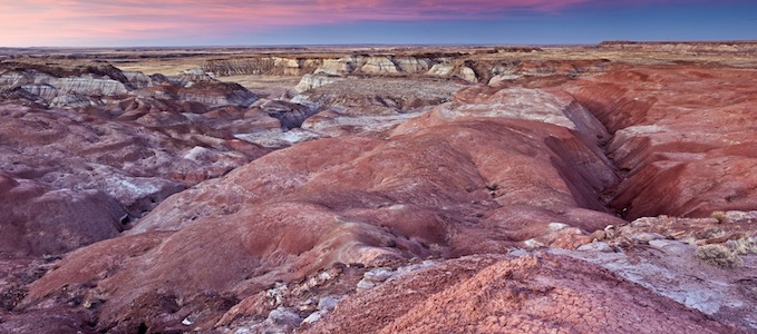
A view across part of the McCauley Ranch that was purchased to be given to Petrified Forest National Park. NPS photo.
Seemingly Rich Reserves
In 2012, Passport Potash hired a consultant to survey the potash orebed, and that survey indicated a "potential" reserve of between 460 million to 500 million metric tons of KCL (potassium chloride).
"There has been insufficient exploration to define a mineral resource and it is uncertain if further exploration will result in the target being delineated as a mineral resource," the company said on its website.
Last week Superintendent Traver attended a meeting at which Passport officials stated their intent to use mining techniques similar to those used in coal mining, in which pillars of coal are left standing to support the shaft's ceiling, rather than an approach that would use a solution to dissolve and extract the potash, if they move forward with their project. In coal mining, those pillars are pulled to recover the fossil fuel as miners retreat at the end of the mine's life.
“That’s good news for us, because it doesn’t involve anywhere near as much water," he said. "They’re still going to be some evaporation ponds, but there’s not as much surface used for evaportation.”
But even if the park sometime down the road is able to purchase the surface rights to the Twin Buttes Ranch, deep mining could one day lead to subsidence -- the collapse of the surface overhead.
"While it’s being mined, nobody wants subsidence," Superintendent Traver said. "The challenge is once they’re on the their way out, then they’ll take the pillars (of ore) out and we’ll have to see what happens.”
This year state officials will be working to develop a baseline of the park's surface that can be used down the road to measure subsidence.
Time To Assess The Past
That said, any potash mining, either on the Twin Buttes Ranch or involving reserves under the Hatch Ranch on the eastern side of the park, is seen as coming years down the road. For now, Bill Parker, the park's paleontologist, and other park staff are waiting for the Park Service to take control of the McCauley Ranch so they can explore it.
"We already know that there is paleontology out there," Superintendent Traver said. "The paleontologist has been itching to get out there for years. He sees things (fossilized remains) coming out of the ground and he can’t touch them.”
There also are petroglyphs and pictographs and other archaeological sites, he said.
Though a purchase price of the McCauley Ranch wasn't announced, those involved described the acquisition as invaluable.
“The exceptional and irreplaceable prehistoric resources found at Petrified Forest National Park have amazed and captivated Americans for generations, and they should be preserved for the insights they provide into our nation’s cultural and ecological history,” said Mike Ford, Southwest director for The Conservation Fund.
Traveler footnote: For more coverage of Petrified Forest National Park, including hiking posts, geological information, photography tips, and more, check out our Essential Guide to the park.


