
Morning fog in Ozark National Scenic Riverways. Photo by Wayne Goode.
Editor's note: Earlier this year Ozark National Scenic National Riverways was named to American River's list of Most Endangered Rivers. Park officials contested that dubious listing, questioning the number of trails open to horse travel cited by American Rivers, as well as that group's concerns over rampant off-road vehicle use in the riverways. In this, the second part of her series, Susan Flader, who long taught in the University of Missouri-Columbia History Department, looks at many of the challenges facing the riverways. The article originally appeared in The George Wright Forum, the journal of the George Wright Society, and we publish it here with their permission.
During the years following the 1991 roads and trails study, there was little information presented to the public about further NPS actions, monitoring or plans, only occasional anecdotal evidence or remarks of former or retired ONSR staff that fed a growing sense that all was not well.
Visitation dropped from a high of nearly 2 million a year to only about 1.3 million. Many canoeists simply stopped going to ONSR, and others brought back reports of boorish, drunken behavior along the riverways, horses and ATVs in the river, inappropriate development, or obvious violations of scenic easements. There was a series of reports of high fecal coliform pollution from horses on the lower Jacks Fork and an eight-mile stretch of the river was added to the state’s list of impaired waters. Ecologists grew concerned about the precipitous decline of the Ozark hellbender, found only in these rivers, and asked the U.S. Fish and Wildlife Service to list it as an endangered species.
County road crews brazenly bulldozed new roads to the river, knowing they would not be challenged. And ATV use proliferated, with one local dealer stocking so many that he had to store them, still crated, in stacks five or six high.
New superintendents, soon after they arrived, would talk bravely about getting control of the problems, but later, when conservationists would ask them about specific issues, they would hear excuses or be told to wait for the new general management planning process.
The GMP process, however, kept getting delayed, finally held scoping meetings in 2006, then went quiet again. Meanwhile, leaders of a number of concerned conservation organizations started an informal Friends of Ozark Riverways to discuss issues, seek reports and data through Freedom of Information Act requests, and begin to document problems in preparation for the upcoming planning process.
One of the organizations, the Missouri Coalition for the Environment, filed suit against NPS regarding easement violations (especially unwarranted land exchanges and blatant new home construction) and repeated failure to follow the National Environmental Policy Act, resulting in serious degradation; they reached a settlement in 2006 in which NPS agreed to evaluate impacts on several already completed projects and commit to following the environmental review and public participation requirements of NEPA in the future.
Another group prepared a slide program and then a video on “Why We Must Save the Current River, Again.”
When the time finally came, in the late summer of 2009, for public comment on preliminary management alternatives for ONSR, NPS was deluged with thousands of responses, reportedly more than on any recent issue except the Yellowstone winter use controversy— about half (largely from the immediate vicinity of the riverways, where ONSR held numerous meetings and media outreach) asking for “no action,” meaning no further regulation, and the other half advocating much stronger management, resource protection, and restoration.
Even as NPS began digesting the dichotomous comments and preparing for the draft GMP, a FOR researcher, Jerry Sugerman, began plumbing NPS reports and aerial photographs in an effort to further document the proliferation of river access roads and horse use since the 1991 study.
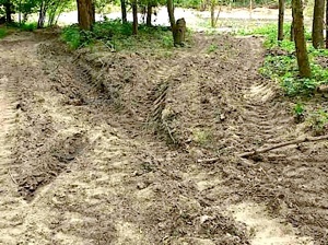
Heavy ATV use has damaged various sections of the riverways. Friends of Ozark Riverways photo.
Some 30 of the 54 road segments designated for closure seemed to have been closed, many of them duplicate roads. It turned out that ONSR had done another park-wide field inventory of drivable roads within park boundaries during 2004–2005 with GPS technology and found a total of 346 miles, compared with 318 miles in the 1991 study, but never released the results. Only 288 miles of the earlier roads were recorded as drivable in 2005, meaning there had been a gain of 58 miles of unauthorized new roads.
Add to that the 17 miles of roads slated for closure in 1991 that still remained open and there were 75 more miles of roads than had been anticipated even in the weak rivers and trails study of 1991. Furthermore, instead of the 91 river access points accessible by motor vehicle that had been mapped in the 1991 study, there were now at least 136.
As FOR wrote in its illustrated report:
The impact of all this vehicular activity along the riverbanks on soil stability and native riparian and aquatic habitats is severe. And the impact on the experience of many of the far greater numbers of people who annually float the rivers is gut-wrenching. There is almost nowhere that a floater can land on a gravel bar and walk into the woods without being assaulted by a maze of rutted, heavily eroded roads, scarred or dead trees, and degraded habitat, not to mention the frequent sights from the river of vehicles and their tire tracks on gravel bars and river banks. Moreover, many of the gravel bars originally intended by Congress and early park planners for swimming, fishing, picnics, or overnight camping by floaters are appropriated by motor vehicles for weeks on end and virtually all are subject to invasion from the rear by horse riders by day and ATV and truck drivers by day and night. No wonder many people who formerly enjoyed floating the Ozark National Scenic Riverways no longer think of going there.
Horse use and new de facto horse trails had also greatly proliferated. By 2010, Cross Country Trail Ride along the Jacks Fork boasted 3,003 stalls for horses, and there were numerous new horse facilities outside park boundaries whose riders used park roads and horse-made trails, especially along the upper Current River.
From a FOIA request, FOR’s Sugerman found that there had in fact been an abortive effort at dealing with the problem during the late 1990s under new ONSR Superintendent Ben Clary. At the initial staff meeting in 1996, according to the minutes, “the biggest issue discussed” was the policy on use of non-designated horse trails in the 1991 roads and trails study: “Wording in the R&TP was not widely discussed prior to being inserted in the plan. 36CFR specifically states that horse use is prohibited outside designated trails” (NPS 1996).
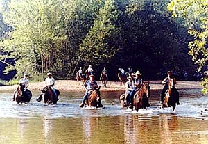
There are concerns about excessive horse use in the riverways. Friends of Ozark Riverways photo.
At a meeting with equestrian stakeholders in 1999, Superintendent Clary said ONSR monitoring showed that horse use had doubled between 1985 and 1995 and it had clearly continued to expand since then, and he asked equestrians to help map all the trails within the park.
By April 2000 a core team had produced four large maps detailing the route of every segment of de facto horse trail, including river crossings. Within the 56-mile stretch of the Current from the upstream boundary to Goose Bay there were 51 miles of horse trail running parallel to the river on the flood plain, 83% of which were used exclusively for horse riding. There were nearly 30 miles of additional flood plain trail in other sections, in addition to numerous trails on higher ground.
Using the four NPS maps, Sugerman digitized all the points where the de facto horse trails crossed a river or the park boundary, finding 83 river crossings and 164 boundary crossings. Subsequently a team consisting of only one ONSR staffer and 19 equestrians proposed two different types of horse trail plans. One would have established 24 officially designated loop trails plus connector trails for a total of 259 miles, plus 25 staging areas, plus parking areas, comfort stations, signs, and hitching rails, all on park property. The other would have allowed for what might be described as non-designated trails of essentially the same configuration but without any signage; horse use and pack-in camping would be allowed on all trails, traces and roads in the park, with parking and horse camping allowed in all primitive areas.
Whether because Clary retired and was replaced by a new superintendent who died within a year, or because the stakeholder-developed alternatives were deemed infeasible, or because park officials simply lost interest, the planning effort was apparently dropped. And there has apparently been no further effort to regulate horse use beyond some limits on group size in the permitting of four massive trail rides a year sponsored by Cross Country Trail Ride.
When a “listening session” for President Obama’s initiative, America’s Great Outdoors, was belatedly scheduled for East Alton, Illinois, in August 2010, at which Secretary of Interior Ken Salazar and NPS Director Jon Jarvis were present, several FOR members spoke passionately about the problems at ONSR, gave them written material and a blown-up version of Sugerman’s map of river access points, and asked for their help.
Salazar and Jarvis listened intently and promised to look into the problems. Subsequently, Jarvis and other NPS officials held a conference call with FOR to further discuss the problems. Because it became clear during that call that ONSR intended to proceed with its general management plan on the basis of its 1991 Roads and Trails Study, FOR prepared and submitted to Jarvis a report showing that the 1991 study was flawed and obsolete, asking for management of ONSR according to NPS standards and policies, and asking that NPS prepare a full environmental impact statement to address the cumulative environmental impacts of the proliferation of vehicular river access and uncontrolled horse use (FOR 2011).
As of this writing, NPS has not yet responded to this request.
When American Rivers announced on May 17, 2011, that Ozark National Scenic Riverways was included on its 2011 list of America’s most endangered rivers, citing overuse, poor planning, and inadequate management, the only known response from NPS came in comments on an article in the website National Parks Traveler from Faye Walmsley, information officer for ONSR, who questioned some of the statistics, pointing out that off-road use of ATVs in the park is illegal, as is horse use beyond the now-23 miles of designated trails.
While national media coverage of the announcement tended to be matter-of-fact and urban media in Missouri supportive of increased attention to problems at ONSR, some local media along the riverways, as might be expected, were resentful of an outside organization meddling in local affairs. But even they acknowledged problems along the riverways.
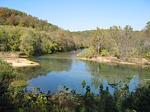
The confluence of the Jacks Fork and Current rivers. NPS photo.
The situation at Ozark National Scenic Riverways seems to be a classic case of park management “going local.” New NPS officials assigned to the park recognize the problems when they first arrive, but soon realize that it is easier—perhaps even safer—to give in to vocal local demands.
There are some in the area who think that ONSR is not really a national park, that it is just a recreation area, but it is unclear from examination of the sources going back to the earliest involvement of NPS where that idea found support. There are legions of people in the region who love the rivers, are upset at what is happening to them, and want to see better management by NPS, though many have been reluctant to speak out.
Midwest regional officials clearly recognized that ONSR is not being managed according to national park standards and policies, but they were willing to look the other way, perhaps out of wariness of a difficult political situation, or because they think the park is safely buried deep in the Ozarks and nobody much cares.
But the Current and Jacks Fork rivers, despite decades of abuse and neglect, are still by far the best—the most stunningly beautiful and most biologically, geologically, and culturally diverse—float streams in Missouri. These rivers were the first in the nation to be federally protected, and their watershed is an area of global biological significance. People travel hundreds or thousands of miles to float these streams, some of them annually.
Ozark National Scenic Riverways, a prototype for our national system of wild and scenic rivers, is about to celebrate its fiftieth anniversary in 2014. Surely these rivers are worth the best management the National Park Service can provide.
We have withdrawn from the rivers, our primary resource and purpose for the park. We have withdrawn from preserving and interpreting the Ozarks cultural heritage which is so important to the area…. Perhaps we need to re-evaluate where we are headed. Are we in fact Ozark National Scenic Riverways or Ozark National Scenic Campgrounds? While all of our activities and visitors are important to us, I think that it is time to start looking at quality and purpose as opposed to quantity. — ONSR Superintendent Ben Clary to Congressman Bill Emerson, March 14, 1996
Story Categories:
A copy of National Parks Traveler's financial statements may be obtained by sending a stamped, self-addressed envelope to: National Parks Traveler, P.O. Box 980452, Park City, Utah 84098. National Parks Traveler was formed in the state of Utah for the purpose of informing and educating about national parks and protected areas.
Residents of the following states may obtain a copy of our financial and additional information as stated below:
- Florida: A COPY OF THE OFFICIAL REGISTRATION AND FINANCIAL INFORMATION FOR NATIONAL PARKS TRAVELER, (REGISTRATION NO. CH 51659), MAY BE OBTAINED FROM THE DIVISION OF CONSUMER SERVICES BY CALLING 800-435-7352 OR VISITING THEIR WEBSITE. REGISTRATION DOES NOT IMPLY ENDORSEMENT, APPROVAL, OR RECOMMENDATION BY THE STATE.
- Georgia: A full and fair description of the programs and financial statement summary of National Parks Traveler is available upon request at the office and phone number indicated above.
- Maryland: Documents and information submitted under the Maryland Solicitations Act are also available, for the cost of postage and copies, from the Secretary of State, State House, Annapolis, MD 21401 (410-974-5534).
- North Carolina: Financial information about this organization and a copy of its license are available from the State Solicitation Licensing Branch at 888-830-4989 or 919-807-2214. The license is not an endorsement by the State.
- Pennsylvania: The official registration and financial information of National Parks Traveler may be obtained from the Pennsylvania Department of State by calling 800-732-0999. Registration does not imply endorsement.
- Virginia: Financial statements are available from the Virginia Department of Agriculture and Consumer Services, 102 Governor Street, Richmond, Virginia 23219.
- Washington: National Parks Traveler is registered with Washington State’s Charities Program as required by law and additional information is available by calling 800-332-4483 or visiting www.sos.wa.gov/charities, or on file at Charities Division, Office of the Secretary of State, State of Washington, Olympia, WA 98504.
