You are here

Flooding Closes Land, Water Trails At Big Thicket National Preserve In Texas

Share

Published Date

June 2, 2015
Alternate Text
Floodwaters have left many trails in Big Thicket National Preserve unsafe and under water/NPS

Recent storms have quite literally left Big Thicket National Preserve in Texas soaked, and forced the temporary closure of many trails, both on land and in water.

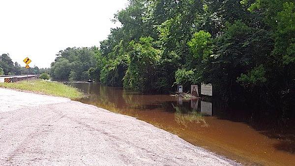
Acting Superintendent Edward Comeau says that due to significant storm activity and record-setting rains, many of the hiking trails and paddling trails throughout the preserve are completely inaccessible and will be closed for approximately a week to ten days. Fallen trees, swollen waterways overflowing their banks and significant standing water throughout the preserve have prevented park staff from safely accessing many of the trails. Of the ten official trails in the preserve, currently only the inner loop of the Sundew Trail, the elevated boardwalk section of the Pitcher Plant trail, and the Big Sandy Trail are open and safe for visitors to explore.

Visitors are reminded that flood waters and saturated soil can create many unsafe conditions. River banks can easily collapse and foot bridges can be weakened due to the waterlogged conditions. Do not walk through moving water. Six inches of moving water can be enough to create a significant hazard. Do not drive on flooded roadways. Just a few inches of flood waters can sweep away you and your vehicle. 

In the coming days and weeks, park staff will begin work to remove fallen trees, repair foot bridges, and restore the preserve trail network to safe conditions. You can find updates on trail conditions at the park's website and its Facebook page.

Big Thicket National Preserve is in southeast Texas just north of Beaumont and 75 miles northeast of Houston. The preserve consists of nine land units and six water corridors encompassing more than 112,000 acres scattered across a 3,500-square-mile area. The Big Thicket, often referred to as a 'œbiological crossroads,' is a transition zone between four distinct vegetation types '“ the moist eastern hardwood forest, the southwestern desert, the southeastern swamp, and the central prairies. Species from all of these different vegetation types come together in the thicket, exhibiting a variety of vegetation and wildlife that has received national interest.

Support National Parks Traveler

Your support for the National Parks Traveler comes at a time when news organizations are finding it hard, if not impossible, to stay in business. Traveler's work is vital. For nearly two decades we've provided essential coverage of national parks and protected areas. With the Trump administration’s determination to downsize the federal government, and Interior Secretary Doug Burgum’s approach to public lands focused on energy exploration, it’s clear the Traveler will have much to cover in the months and years ahead. We know of no other news organization that provides such broad coverage of national parks and protected areas on a daily basis. Your support is greatly appreciated.


EIN: 26-2378789

Support Essential Coverage of Essential Places

A copy of National Parks Traveler's financial statements may be obtained by sending a stamped, self-addressed envelope to: National Parks Traveler, P.O. Box 980452, Park City, Utah 84098. National Parks Traveler was formed in the state of Utah for the purpose of informing and educating about national parks and protected areas.

Residents of the following states may obtain a copy of our financial and additional information as stated below:

  • Florida: A COPY OF THE OFFICIAL REGISTRATION AND FINANCIAL INFORMATION FOR NATIONAL PARKS TRAVELER, (REGISTRATION NO. CH 51659), MAY BE OBTAINED FROM THE DIVISION OF CONSUMER SERVICES BY CALLING 800-435-7352 OR VISITING THEIR WEBSITE. REGISTRATION DOES NOT IMPLY ENDORSEMENT, APPROVAL, OR RECOMMENDATION BY THE STATE.
  • Georgia: A full and fair description of the programs and financial statement summary of National Parks Traveler is available upon request at the office and phone number indicated above.
  • Maryland: Documents and information submitted under the Maryland Solicitations Act are also available, for the cost of postage and copies, from the Secretary of State, State House, Annapolis, MD 21401 (410-974-5534).
  • North Carolina: Financial information about this organization and a copy of its license are available from the State Solicitation Licensing Branch at 888-830-4989 or 919-807-2214. The license is not an endorsement by the State.
  • Pennsylvania: The official registration and financial information of National Parks Traveler may be obtained from the Pennsylvania Department of State by calling 800-732-0999. Registration does not imply endorsement.
  • Virginia: Financial statements are available from the Virginia Department of Agriculture and Consumer Services, 102 Governor Street, Richmond, Virginia 23219.
  • Washington: National Parks Traveler is registered with Washington State’s Charities Program as required by law and additional information is available by calling 800-332-4483 or visiting www.sos.wa.gov/charities, or on file at Charities Division, Office of the Secretary of State, State of Washington, Olympia, WA 98504.

Comments

An unfortunate situation for this, and other parks affected by the recent flooding.

Some may wonder why high water makes any difference for a "paddling trail." These routes can be a great way to explore some magnificent bottomland hardwood forests, but when these creeks and bayous are out of their usual channels, and everything is under murky water, every place looks pretty much the same. Landmarks in such flooded forests are hard to pick out, and the current running through a broad area of flooded trees instead of in a defined channel can make handling a canoe or even small powerboat very tricky. These are the times when it's easy to understand the legends about people getting seriously lost and stranded in the Big Thicket.

If anyone needs more reasons to stay out of these flooded woods, here's one more: When I worked there during the early days of this park, we often joked that there were places where we could guarantee seeing "20 pounds of cottonmouth moccasin to the acre" - and when the water is this high, that could apply to a LOT of places in these woods and swamps :-)


Donate Popup

The National Parks Traveler keeps you informed on how politics impact national parks and protected areas.

Support Our Mission

INN Member

The easiest way to explore RV-friendly National Park campgrounds.

The Essential RVing Guide to the National Parks

Here’s the definitive guide to National Park System campgrounds where RVers can park their rigs.

Our app is packed with RVing- specific details on more than 250 campgrounds in more than 70 national parks.

You’ll also find stories about RVing in the parks, tips helpful if you’ve just recently become an RVer, and useful planning suggestions.

The Essential RVing Guide to the National Parks

FREE for iPhones and Android phones.