You are here

Visit Kalispell, Your Gateway to Glacier National Park

Kalispell, Montana, Your Gateway to Glacier National Park

On The Border: Two Countries, Two Great Parks

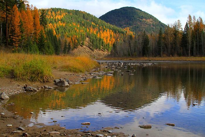
Belton Mountains, Middle Fork of the Flathead River in Fall/NPS, David Restivo

Take a colorful road trip to Glacier and Waterton Lakes national parks this fall/NPS photo of Belton Mountains and the Middle Fork of the Flathead River in Glacier by David Restivo

Many people visiting Glacier National Park in Montana don't realize that it has a twin sister just across the Canadian border: Waterton Lakes National Park. This autumn, take some time to explore The Crown of the Continent - these high peaks, deep valleys, and very long lakes.

Back in 1932 these two parks were forever united when they were designated as the world's first International Peace Park, and the geographical binding makes the two a perfect combination for a road trip. It's just a 45-minute drive east from Kalispell, Montana, to Glacier, where you'll look up the length of Lake McDonald, nestled in a broad forested valley, high peaks at its head. Then head up Going to the Sun Highway as it switchbacks up the rocky cliffs. It's one of the truly classic, breathtaking drives of all time, and you'll spot moose, mountain goats, and all sorts of alpine creatures including bald and golden eagles.

There are more than 700 miles of trails in the park, so take advantage of the fall weather and stretch your legs. The Hidden Lake Nature Trail at Logan Pass makes a good introduction to the alpine environment. It leads you across open meadows that provide expansive views of not only the Garden Wall and U-shaped valleys that glaciers plowed, but also of the locals: mountain goats and bighorn sheep.

Once over the pass, head down towards Saint Mary Lake, but make sure you picnic at Baring Falls in the Sunrift Gorge.

Once out of the park at the town of St. Mary, start heading north along the Chief Mountain International Highway towards the border. Golden cottonwoods line the river valleys. Within the hour — after crossing through the border checkpoint — you’ll be at Waterton Lakes National Park, which is every bit of spectacular, but doesn't get nearly as much attention, as does Glacier.

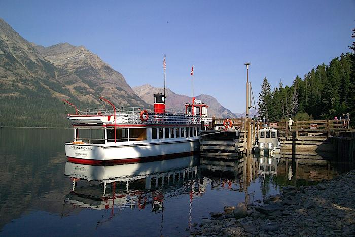
Here you can hike or take the shoreline cruise on M.V. International up this glacial lake, where you'll spot moose, bear, and eagles along the shore. After a stop at Goat Haunt, you'll return in time to marvel at the scenery and the incredible Prince of Wales Hotel. And in autumn, chances are that the skies will be clear and blue, and the crowds will be few.

M.V. International, Waterton Lakes National Park/NPS

At Waterton Lakes, take a boat cruise along Waterton Lake/NPS photo by David Restivo

Studying Mountain Goats At Glacier National Park

If you've been to Glacier National Park, and spent time in the Logan Pass area, you just might have had an impact on the mountain goats that hang out there, and not necessarily a good one.

You see, most of the park's goats that aren't used to humans stick to cliffs and ledges, and only occasionally trot off to meadows to browse the vegetation. Those goats that are used to our presence spend more time in meadows and along park roads.

Mountain Goat at Logan Pass, Glacier National Park/Kurt Repanshek

Mountain goat studies are continuing at Glacier National Park/Kurt Repanshek

Those are some of the initial findings coming from a multi-year study of mountain goats in Glacier by park staff in partnership with the University of Montana, and Montana Fish, Wildlife and Parks. The three-year study began in late summer 2013 and is designed to provide information on how mountain goats are affected by roads, people, and trails near Logan Pass. The study is a critical component of the current Going-to-the-Sun Road Corridor Management planning effort, which identified human-wildlife interactions within the corridor as an issue of concern, park officails said.

Six mountain goats received radio collars in 2013 and an additional 18 animals received radio collars in summer 2014. A total of 24 mountain goats, consisting of seven males and 17 females, received collars and successfully overwintered in the Mount Cannon and Hidden Creek drainage. VHF and GPS radio collars are utilized to collect location data. VHF collars only collect a data point when they are located by an observer on the ground or in an aircraft, whereas GPS collars collect a data point every few hours and then transmit that information via satellite to a researcher’s computer.

As the study goes on and more data are collected, the initial findings of how mountain goats behave around humans could change.

Flying into Kalispell, your eyes dart here and there, trying to take in all the peaks clawing skyward.

While this laid-back Montana town is the western gateway to Glacier National Park, it's also seated in the Crown of the Continent, an idea as much as a phrase that captures Rocky Mountain wildness.

It's a 10-million-acre chunk of wildness, one that overlaps the U.S.-Canadian border and comes with rivers swift, cold, pristine, and brimming with trout; forests that still hold bears and wolves, elk and deer, wolverine and fox; and adventures that will wear you out.

It's a large swath of the Northern Rockies that, once you get away from roads and towns, looks unchanged from when 19th century mountainmen roamed the landscape and Lewis and Clark passed through to the south.

There are mountain ranges -- Mission Mountains, the Flathead RangeSwan Range -- that hold deep forests clinging to the spine of the Continental Divide as it soars above 8,000 feet. Complementing these timberlands with their crags are wilderness areas equally evocative in name -- the Great Bear Wilderness and Scapegoat Wilderness that are part and parcel of the Bob Marshall Wilderness Complex

Sundown at Flathead Lake, Kalispell, Montana/Chuck Haney

Sundown on Flathead Lake, Kalispell, Montana/Chuck Haney

Stretching north into Canada, this rugged Crown counts both Glacier and Waterton Lakes national parks, two siblings tied at the US-Canadian border that together are known as the Waterton-Glacier International Peace Park, designated as such in 1932 to "commemorate the peace and goodwill our two nations share," notes Parks Canada. 

Rivers that feed into both the Atlantic and Pacific -- and even Arctic -- oceans find their way into the world here. From Triple Divide Peak on the eastern side of Glacier snowmelt trickles into Pacific Creek to head west, Hudson Creek to flow north, and, naturally, Atlantic Creek to move east.

For travelers seeking solitude in an earlier era, this is the place.

Located on the western edge of the Crown, Kalispell is a resting stop, of sorts. Or, better yet, a launching point.

Lying due east of the Salish Range, the town's name evolved from the Salish word, "qlispel," which tranlsates to "flat land above the lake." The lake in question is Flathead Lake, a nearly 30-mile-long, north-south running body of deep, cold water that is the largest natural freshwater lake west of the Mississippi. The flat land along the northern tip of the lake holds this city of roughly 21,000 that lies about 45 miles from West Glacier, the western terminus, by road, of Glacier National Park.

Unlike many gateway towns that practically border their national parks, Kalispell comes with a little breathing room between it and Glacier. And that is a very good thing if you're looking to savor the essence of not just a national park, but the region that surrounds it.

Read the rest of the story here.

Winter Fun In And Around Kalispell

Kayaking on Lake McDonald in Winter/Discover Kalispell

Discover how to enjoy winter at Glacier National Park.

No Matter When You Visit, Kalispell Has Something To Offer You

Kalispell, Montana: Discovery In Every Direction