Visitors to the far north might think they know what's big. That is, until they see it, touch it, and feel it. In Alaska, peaks and glaciers, rivers and lakes, waterfalls and forests, beaches and bays stretch far away to all horizons, nearly untouched by the hand of man.
Even the chattiest air traveler will grow quiet as they fly for hours over pristine landscapes. Things are different up North, and that's why we love it. It's big, wild, and quiet; not a place for the distracted or unprepared visitor. It's also what attracts us for a renewal-by-wilderness.
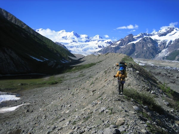
"Big" is all around you when you backpack in Wrangell-St. Elias/NPS
Autumn is absolutely the best time to explore what the sourdoughs call South Central, the jumble of mountain ranges of the Wrangell- St. Elias National Park and Preserve. Golden birch and alder line the streams; the skies are intensely blue; and the bugs have subsided. Nights are cool and days are warm but termination dust (what old timers call the first snow) can cover the peaks from the end of August on, like frosting on a cake.
It's our largest national park at 21,000 square miles. In fact, it's six times the size of Yellowstone in the Lower 48. Now, Alaska has less than one person per square mile, with half of those 500,000 in Anchorage. To the north, Denali National Park and Preserve welcomes a half-million visitors a year. But Wrangell-St. Elias? Only a tenth of that number. It's big, vast and nearly endless; from the coastal plains to 18,000-foot, glacier-covered peaks.
One climber summed up the difference this way: 'In the Lower 48 you might approach a peak, hike to its base, climb to the top, and be back home for dinner. In the Arctic it may take you days to get to the beginning, a week of 'alder bashing' to climb above timberline. Then, more days hiking the glacier, and only then you can start your climb.' It's a matter of scale, and humbles even the hardiest travelers. 'During the 1970s' oil boom, more than one Texas oilman was told that Alaskans were going to cut their state in half and so make Texas the third-biggest state. This park has everything a wilderness enthusiast wants. It holds the greatest concentration of peaks in North America over 16,000 feet. Here are the biggest glaciers on the continent, as well as the largest concentration of volcanoes. There are historic railroads and mines. The glacial, salmon-filled rivers are lined with hungry bears and eagles. There are moose in the willows and the white dots of Dall sheep on the sheer cliffs. Big mountains hold big glaciers that form the big rivers: the Copper, Chitina, Nabesna, and White rivers all headed to the sea.
Four different mountain ranges bracket the park: the Alaska Range to the north, the volcanic Wrangell and St. Elias ranges in the center, and the coastal Chugach Mountains on the south. Steam plumes soar over Mt. Wrangell's summit at times, testimony to the fire that underlies the ice. The Nabesna Glacier on the north border is the longest in the world, at 75 miles. To the south, the Malaspina Glacier pours out of the mountains onto the coastal plain, the world's largest piedmont glacier. Its ice is more than 2,000 feet thick and would add six inches to sea level if it ever fully melted. The future might have that in store, actually, as others, such as the Hubbard Glacier, are retreating quickly.
Getting to the park can be as quick and easy as an air-taxi flight to McCarthy, the park's main southern entrance, Nabesna to the north, or dozens of backcountry sites in-between. To truly see the whole park, splurge and take an aerial tour and soar in front of sheer rock faces, and watch as the glaciers merge, a flow stripe denoting each confluence.

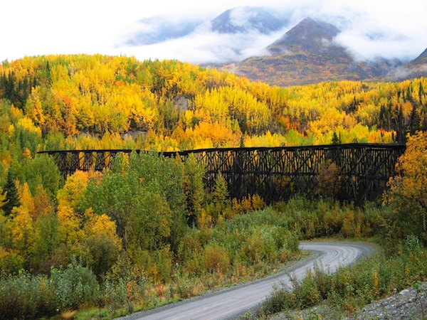
Fall color envelops the area along the McCarthy Road/NPS
For those with a decent vehicle, more time, and less cash, take the 4-hour drive from Anchorage along the stunningly magnificent Glenallen Highway, then south to the town of Chitina where the Chitina River joins the Copper River, the only river to cut through the rugged Chugach Mountains to the Gulf of Alaska. At Chitina, make sure you're prepared for some backcountry driving: there's no gas where you're going, so fill up here. And make sure you have a good jack and a couple of spare tires, too.
The 60-mile unpaved McCarthy Road follows the Chitina River's north bank, along an old railroad grade. A passenger car won't have any problems, but flats are common. And there's a lot to see and do on the way. Spend some time hiking and fishing, marvel at the railroad trestles, and try and keep at least one eye on the road and not on the soaring peaks: the single-lane Kuskulana Bridge, built in 1910, is 238 feet above a raging river, and just recently gained a guard rail.
The drive will take around three hours from Chitina to McCarthy, and there's no toll booth or entrance station in sight. There's no vehicle bridge at McCarthy, so leave your car and walk the footbridge across the Kennicott River into town. (Until 1997 you would have had to pull yourself across a hand-powered tramway.) The main gateway into the park, McCarthy has a smattering of lodges, guides, and cafes, with only 100 residents, but it wasn't always that way.
Eighty years ago it was a raucous, rough town of ten times that number, catering to the miners from the nearby, historic Kennecott Copper Mine. If you stay in McCarthy you can hike the 5-mile trail (or hitch a ride on a shuttle) up the west side of the Root Glacier to the rustic, red-painted historic town and mill. In 1998 it was acquired by the National Park Service and is now a National Historic Landmark.
The Gilahina Trestle/NPS
The mine here opened in 1907, and more than $200 million in copper ore was shipped out during its 30-year heyday. Originally the high-grade ore was hauled out by a steamship that was hauled piece by piece over the mountains and rebuilt on the river. Its first shipment in 1911 held $250,000 of copper. Finally it was replaced by the railroad that is now the road in.
And this mine was undoubtedly the richest copper deposit ever discovered, with up to 70 percent pure chalcocite. Prospector Jack Smith wrote of the copper outcrop he found in 1900: 'I've got a mountain of copper up there. There's so much of the stuff sticking out of the ground that it looks like a green sheep pasture in Ireland when the sun is shining...' There was so much of it, in fact, that miners took a horse-drawn sleigh onto the Root Glacier to pick up the blue-green rocks that had been torn off the cliffs and carried down by the ice.
A trip to the town and mill is a glimpse backwards in time. The towering mill, bunk houses, and offices are all covered with the original copper oxide paint, but have weathered well in the harsh climate. The mines themselves are 3,000 feet above the town, and were serviced by an aerial tramway carrying the ore down, and miners up. Bold hikers can climb the mountains to the Erie, Jumbo, and Bonanza mines. Though the mines closed in the late 1930s, they did give birth to the global Kennecott Mining Company.
For mountaineers there are challenges here for a lifetime. In 1937, legendary mountaineer and photographer Bradford Washburn and friends set out to climb Mount Lucania (17,147 feet), at that time the highest unclimbed peak in North America. Only two of the group were able to land on the glacier before bad weather forced the plane away, and after surviving avalanches, crevasses, and whiteout snowstorms they made the summit. But the real challenge was yet to come. Unable to retreat by plane due to soft snow, they were stranded for a month on the glacier. Running out of supplies, and with winter looming, they finally retreated across a hundred miles of uncharted Yukon Territory to safety.

The Kennicott Mill photographed at night in 1937/ John Cone
Ice, snow, and rock climbers still push up new routes on such classic peaks as Mount Drum, Mount Bona, and Mount Blackburn, the fifth-highest peak in the United States at 16,390 feet. For a true wilderness experience, fly into one of the 14 public-use cabins scattered within the park, remote and mostly first come-first served. Or fly into a luxury lodge within the park.
Make sure you take your fishing pole, though, because you will not be disappointed. And, interestingly, hunting and trapping are allowed within Wrangell- St. Elias National Park and Preserve. Within the national park it's limited to those locals who depend upon the meat for their survival, but sport-hunting is allowed on the national preserve.
If that's all a bit too intense, then base from McCarthy at one of the rustic lodges, hike, raft, camp, fish and just enjoy the wonderful fall weather, in what is truly one of America's most beautiful and pristine landscapes.
If You Go
For park information, visit www.nps.gov/wrst.
Where to Stay
- There are 14 public-use cabins within the park, accessible by air. There is a maximum stay of 7 days in a 30-day period. Most are first come, first served, with no reservations, but three do require reservations and a $25 per night fee. 907-822-7253.
- The McCarthy Lode and Ma Johnson's Historic Hotel
- Ultima Thule Lodge 'air-access only lodge '¢ Kennicott Glacier Lodge Guides and Outfitters '¢ St. Elias Alpine Guides '¢ Kennicott Guides '¢ Copper Oar Rafting
Air Taxi Companies
www.nps.gov/wrst/planyourvisit/upload/ CUA-List-01282013.pdf
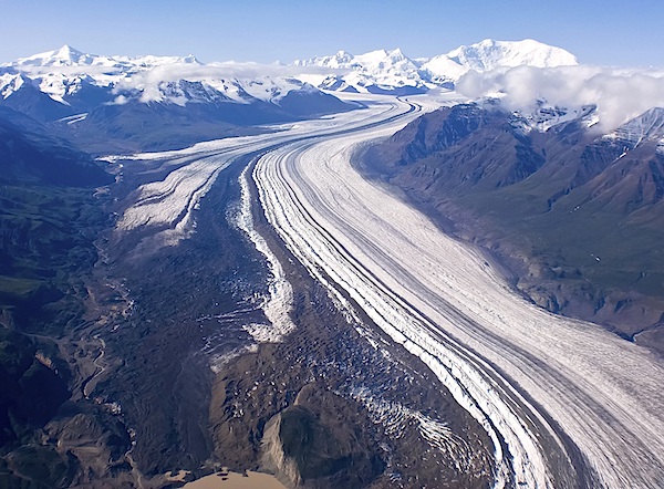
A small section of the 75-mile-long Nabesna Glacier/NPS
Story Categories:
A copy of National Parks Traveler's financial statements may be obtained by sending a stamped, self-addressed envelope to: National Parks Traveler, P.O. Box 980452, Park City, Utah 84098. National Parks Traveler was formed in the state of Utah for the purpose of informing and educating about national parks and protected areas.
Residents of the following states may obtain a copy of our financial and additional information as stated below:
- Florida: A COPY OF THE OFFICIAL REGISTRATION AND FINANCIAL INFORMATION FOR NATIONAL PARKS TRAVELER, (REGISTRATION NO. CH 51659), MAY BE OBTAINED FROM THE DIVISION OF CONSUMER SERVICES BY CALLING 800-435-7352 OR VISITING THEIR WEBSITE. REGISTRATION DOES NOT IMPLY ENDORSEMENT, APPROVAL, OR RECOMMENDATION BY THE STATE.
- Georgia: A full and fair description of the programs and financial statement summary of National Parks Traveler is available upon request at the office and phone number indicated above.
- Maryland: Documents and information submitted under the Maryland Solicitations Act are also available, for the cost of postage and copies, from the Secretary of State, State House, Annapolis, MD 21401 (410-974-5534).
- North Carolina: Financial information about this organization and a copy of its license are available from the State Solicitation Licensing Branch at 888-830-4989 or 919-807-2214. The license is not an endorsement by the State.
- Pennsylvania: The official registration and financial information of National Parks Traveler may be obtained from the Pennsylvania Department of State by calling 800-732-0999. Registration does not imply endorsement.
- Virginia: Financial statements are available from the Virginia Department of Agriculture and Consumer Services, 102 Governor Street, Richmond, Virginia 23219.
- Washington: National Parks Traveler is registered with Washington State’s Charities Program as required by law and additional information is available by calling 800-332-4483 or visiting www.sos.wa.gov/charities, or on file at Charities Division, Office of the Secretary of State, State of Washington, Olympia, WA 98504.
Comments
Beautiful images and nice descriptions.
To give folks an idea of the scope of Alaska, I live in the Southeast. From us Anchorage is less than halfway across the state -- but that is still two ten-hour days drive away. I haven't gotten to explore from McCarthy yet, but this article is very inviting.
Here's the kind of life-changing adventure such a place can provide:
http://www.tetongravity.com/forums/showthread.php/169211-33-Days-Across-...(NSR)