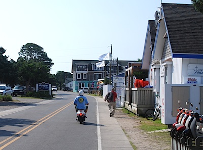
Ocracoke, small and charming, is pedestrian and scooter friendly, particularly in the morning hours, while its beach can be very empty at times. Top photo by Kurt Repanshek, bottom photo by Danny Bernstein.
Ocracoke Island is a jewel of an island on Pamlico Sound in Cape Hatteras National Seashore. The island is accessible only by ferry or private plane or boat, which helps to keep it free from mainstream commercialism.
No golf courses, go-carts, water slides, or even a movie theater. All the restaurants and motels are individually owned and so reflect the owners' personality.
Ocracoke Village, pronounced like the vegetable (okra) and the soft drink (Coke), originally was known as Pilot Town, after the pilots who lived here and made their living guiding ships through the Ocracoke Inlet.
Today you find a small, upper-crust island town with all the tourist amenities; technically, it's not part of the national seashore. The year-round population is about 800 because winters can be chilly and quiet. But in the summer, Ocracoke attracts visitors and summer residents with good restaurants, quality crafts, and historic homes. Plus, you can board a small ferry for a short ride over to historic Portsmouth Village in neighboring Cape Lookout National Seashore.
Though Ocracoke is only a small part of the island, the streets don’t feel crowded. One can get the feel of the village with a walking exploration or aboard a rental scooter in a few hours ... or have a good time for two months.
Here are only a few of the highlights.
Visitor Center
Once off the ferry, your first stop should be the first of three Cape Hatteras National Seashore Visitor Centers. Inside you'll find information on the seashore, rules on beach closures, be able to stamp your Passport to the National Parks, and browse collections of books, maps, and other park materials. There's also a restroom.

The Ocracoke Light. Kurt Repanshek photo.
Ocracoke Lighthouse
Three lighthouses were built on Cape Hatteras, each unique looking.
The Ocracoke lighthouse, erected in 1823, is the second-oldest operating lighthouse in the country and the oldest in North Carolina. Painted white from top to bottom and standing 75 feet tall, it's readily visible in town and a short walk from Highway 12, which also is known as the Irvin Garrish Highway.
Unfortunately, the light is closed to the public. But it is quite picturesque.
British Cemetery
In a residential area of Ocracoke, the British government leased a small patch of land to use as a cemetery for their dead from World War II.
During the war, German submarines attacked U.S. Navy boats. Great Britain offered to help, and sent out 24 retrofitted trawlers to patrol shipping lanes off the coast of North Carolina. On May 11, 1942, a British ship, the HMT Bedfordshire, was torpedoed and sunk by German U-boats. There were no survivors.
Only four bodies were recovered, and today they are buried in Ocracoke. The small, neat graves with concrete gravestones are covered with pebbles and encircled by a white picket fence.
Every year, the National Park Service, the U.S. Coast Guard, and the British Royal Navy have a ceremony at the site, honoring the men who lost their lives in the attacks. A cemetery with a similar history lies farther up Cape Hatteras.
Blackbeard
Many businesses in Ocracoke refer to Blackbeard, or Edward Teach, his real name. Blackbeard, along with his fellow pirates, roamed from the Caribbean to the Outer Banks and north to Virginia, robbing and plundering the ships they came across.
Blackbeard outfitted his ship, the Queen Anne’s Revenge, with three hundred men and forty cannons. He then sailed the Caribbean and the Atlantic along coastal waters of the American colonies, overwhelming merchant ships and stealing their cargo.
Even in the 1700s, Blackbeard knew about marketing. He branded himself as a violent pirate with a tall scraggly black beard, which gave him a fierce and menacing look. The flag on his ship depicted a heart dripping blood with a horned skeleton holding an hourglass and spear.
Unfortunately, marketing only goes so far. Lt. Robert Maynard of the British Navy finally defeated Blackbeard in late 1718 near Ocracoke. For an amusing look at this bit of history, you can visit Blackbeard Museum at Teach's Hole.
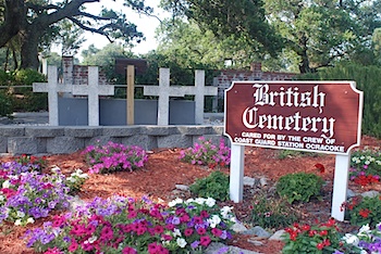
Four British sailors who were killed off the coast during World War II are buried in this small, tidy cemetery in Ocracoke. Kurt Repanshek photo.
Once out of the village, the Outer Banks is quiet. Even today, in tourist terms, the area is considered out of the way with few services. In Ocracoke, the beach is almost deserted.
The Pony Pens
Ocracoke ponies ran free for centuries. Horses have been documented on Ocracoke since the first European settlers came to stay in the 1730s. There have been as many as 300 horses on Ocracoke. Small and powerful, the Banker ponies, as they are known colloquially, are full-grown horses.
Legend has it that the Banker horses of Ocracoke were left here by shipwrecked explorers in the 16th or 17th century. European ships commonly carried livestock to the New World. If a ship ran aground near the coast, animals were thrown overboard to lighten the load so the ship could be refloated.
When Ocracoke was first settled, residents used ponies to pull carts for freight and fish and generally to make life easier on the island. The ponies helped the U.S. Life-Saving Service patrol beaches and haul equipment to shipwreck sites.
In the late 1950s, Ocracoke Boy Scouts cared for the horses, becoming the only mounted scout troop in the nation. But when North Carolina 12 was built through the Outer Banks in 1957 and the ponies had a few encounters with cars, the National Park Service penned them in and has watched over the remaining herd ever since. Currently, the horses in the Ocracoke herd are kept in an enclosure and can be seen from the road.
Birding
You can enjoy watching birds at the seashore without being a birder. At Cape Hatteras National Seashore, the popular birds are big and active. For the most part, they're not hidden by trees and bushes. Sanderlings chase retreating waves, and willets dig their long bills in the sand. A squadron of pelicans hovers over the water and then dives into the sea. An oystercatcher ambling near the dunes can be identified immediately by its prominent red beak.
Protecting Birds and Turtles
If you walk the beach, you'll reach a closure at some point. At times during the spring and summer months the area is off-limits to pedestrians and everything else. Walkers can’t honestly say that they somehow missed a barrier. A rope is stretched across the sand from the dune to the water, and a large sign states that the beach is closed to protect nesting birds, such as the Piping plover, a threatened species protected by the Endangered Species Act. The seashore publishes a list of beach closures on its website weekly during the summer.
Piping plovers and loggerhead turtles, which are proposed to be listed as threatened, can now nest in peace. When you reach a beach closure, you can turn around, walk to the road, or walk in the water.
Camping at Ocracoke Campground
If you look at TripAdvisor, you'll always see comments like "Location, location, location was the most important criteria." If you take the Ocracoke Campground in that spirit, it will work out well for you.
The National Park Service has protected the beach from development. There’s just sand, waves, and birds. Without a boardwalk, motels, or snack bars on the beach, no one would confuse Cape Hatteras National Seashore with Coney Island. If you don’t analyze what you see too closely, it looks like the beach has never been altered.
The campground is located off North Carolina Route 12, three miles east of Ocracoke Village and ten miles west of the Hatteras Inlet ferry terminal. It's the only campground on Ocracoke Island that's right on the beach, a short walk over the dunes. That's the big draw. You can swim, fish, or boat only a few feet from your campsite. The beach looks untouched by human hands. Walk the quiet beach past sanderlings, small shore birds that run back and forth like wind-up toys. If you're lucky, you may see crabs that come out at night. What a sight!
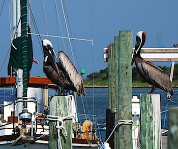
Birds are very visible in and around Ocracoke. Kurt Repanshek photo.
The campground offers grills, flush toilets, drinking water, cold showers; most of the time, it's so warm that you'll be happy with an unheated shower. You'll camp on sandy soil so you'll need extra long tent stakes. RVs, not over 40 feet, are welcome to camp. There's no electricity, but there is a dump station.
The challenges to staying at the Ocracoke Campground campgrounds are two-fold. There is no shade at the campground. Mosquitoes are common, and insect spray is recommended. Depending on the time and your luck, mosquitoes may bug you just from sun down to sun up or all day, as well.
Despite the negatives, the campground is very popular in the summer. Of the four Cape Hatteras campgrounds, Ocracoke is the only one that accepts reservations. For $23 at Recreation.gov, you can get a site for a maximum of six people and your pet. This year, the campground opens on April 5 and closes in late October.
Getting There
You can get to Ocracoke Island from three directions. This is a dynamic area and weather constantly changes the land formation. It's important to check the ferry site close to your departure time.
From the south. If you come from the south, you'll take the Cedar Island Ferry, which takes about two hours and 15 minutes to make the crossing.
From the west. Take the Swan Quarters Ferry, which takes two and half-hours.
Because the North Carolina Department of Transportation runs the ferry system, the fees are very reasonable. A pedestrian can get on for one dollar and a car for fifteen dollars. You can only buy food from vending machines, so it’s best to bring your own. Gulls, terns, and pelicans following the ferry provide plenty of entertainment. Sometimes dolphins ride the waves.
From the north. From Hatteras Island, the ferry normally takes 45 minutes. This ferry is free and doesn't take reservations. In the summer, you can wait in a long line of cars. Right now, the ferry is using a longer temporary route until the Army Corps of Engineers finish the dredging work needed to open the primary route.
The Outer Banks is shaped by the weather. Road and ferry conditions can change quickly and dramatically. Always check the ferry website for the latest information.
Resources
Fordon, Ruth and Scarborough, Jenny. Ocracoke Walking Tour and Guide Book. One Boat Guides, 2009.
Stories about:
Story Categories:
A copy of National Parks Traveler's financial statements may be obtained by sending a stamped, self-addressed envelope to: National Parks Traveler, P.O. Box 980452, Park City, Utah 84098. National Parks Traveler was formed in the state of Utah for the purpose of informing and educating about national parks and protected areas.
Residents of the following states may obtain a copy of our financial and additional information as stated below:
- Florida: A COPY OF THE OFFICIAL REGISTRATION AND FINANCIAL INFORMATION FOR NATIONAL PARKS TRAVELER, (REGISTRATION NO. CH 51659), MAY BE OBTAINED FROM THE DIVISION OF CONSUMER SERVICES BY CALLING 800-435-7352 OR VISITING THEIR WEBSITE. REGISTRATION DOES NOT IMPLY ENDORSEMENT, APPROVAL, OR RECOMMENDATION BY THE STATE.
- Georgia: A full and fair description of the programs and financial statement summary of National Parks Traveler is available upon request at the office and phone number indicated above.
- Maryland: Documents and information submitted under the Maryland Solicitations Act are also available, for the cost of postage and copies, from the Secretary of State, State House, Annapolis, MD 21401 (410-974-5534).
- North Carolina: Financial information about this organization and a copy of its license are available from the State Solicitation Licensing Branch at 888-830-4989 or 919-807-2214. The license is not an endorsement by the State.
- Pennsylvania: The official registration and financial information of National Parks Traveler may be obtained from the Pennsylvania Department of State by calling 800-732-0999. Registration does not imply endorsement.
- Virginia: Financial statements are available from the Virginia Department of Agriculture and Consumer Services, 102 Governor Street, Richmond, Virginia 23219.
- Washington: National Parks Traveler is registered with Washington State’s Charities Program as required by law and additional information is available by calling 800-332-4483 or visiting www.sos.wa.gov/charities, or on file at Charities Division, Office of the Secretary of State, State of Washington, Olympia, WA 98504.
INN Member

The easiest way to explore RV-friendly National Park campgrounds.

Here’s the definitive guide to National Park System campgrounds where RVers can park their rigs.
Our app is packed with RVing- specific details on more than 250 campgrounds in more than 70 national parks.
You’ll also find stories about RVing in the parks, tips helpful if you’ve just recently become an RVer, and useful planning suggestions.

Comments
The Ocracoke based story that was documented in 2010 of the Llyod brothers stealing more treasure in one afternoon, without firing a shot, than Blackbeard did in his entire career is to me bigger than Blackbeard's. I don't understand why there has not been more news about that event. I hope the NPS will make it a part of their story of Ocracoke.
Thanks, JimB. I need to check this out.