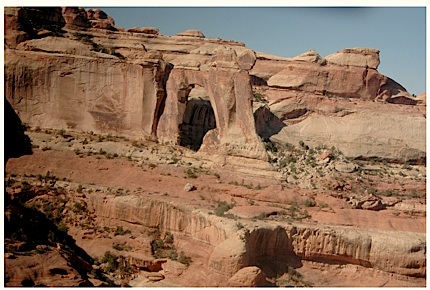
A creek that leads to Angel Arch in the backcountry of Canyonlands National Park is not a public thorofare and not open to vehicles, a federal judge has ruled. The area, along with featuring Angel Arch, is rich in Native American ruins and artwork. Top photo from judge's ruling, photo of Salt Creek by Ted Zukowski, Earthjustice. Bottom photo of rock art by Neal Herbert, National Park Service.
A winding creek that jogs through Canyonlands National Park to a spectacular sandstone arch is not a road, and that finding by a federal judge could send reverberations throughout many Western states anxious to expand access across the federal landscape.
The 81-page ruling (attached below) handed down Friday was long awaited; the trial on the status of Salt Creek ran nine days back in September 2009. Its conclusion -- if not overturned on appeal -- runs a stake through arguments that abandoned Jeep tracks, cattle trails, and even creek beds are legal thorofares under R.S. 2477, a Civil War-era statute initially created to further western expansion.
In 1976 Congress repealed the law, but not before providing that any valid R.S. 2477 route existing at the time of the repeal could continue in use. Since then, there have been many debates and many lawsuits over what constituted a valid R.S. 2477 route.
But in his ruling, U.S. District Judge Bruce Jenkins held that the state of Utah and San Juan County had not demonstrated during the trial that Salt Creek has been used continuously as a public road, and that "a Jeep trail on a creek bed with its shifting sands and intermittent floods is a by-way, but not a highway."
The ruling was heralded as a "landmark decision" in the realm of public land litigation by the Southern Utah Wilderness Alliance, which added that its arrival marks "a great day for Utah Wilderness."
There long have been pockets of disgust over federal land ownership in the West, and perhaps nowhere is that stronger than in Utah, where roughly two-thirds of the landscape is federally managed. While the "Sagebrush Rebellion" mightily reared its head some three decades ago, its waning vestiges were on trial before Judge Jenkins.
The poster child of the rebellion rose up on July 4, 1980, when several hundred people gathered in Moab, Utah, on the doorstep of both Canyonlands and Arches national parks, to celebrate the nation's birthday...and decry federal land-management policies. From atop a Caterpillar bulldozer, one carrying a few "Sagebrush Rebel" stickers and spouting a U.S. flag from its smokestack, county officials complained about federal land managers. After firing up the crowd, the politicians fired up the bulldozer and, while following the scant traces of an abandoned mining road, worked to scrape a path into a nearby Wilderness Study Area on U.S. Bureau of Land Management lands.
Litigation, not bulldozers, has littered the landscape in Canyonlands these past dozen years over whether Salt Creek should be open to off-road vehicles. Born from springs and snowmelt on the Abajo Mountains just about 5 miles the south of the national park, the meandering creek is most vibrant during flash floods that scour the streambed. For the rest of the year, its thin flow depends largely on the output of occasional springs and storms. When enough water fills the creek, it slowly makes its way 32 miles to the Colorado River.
While the national park came out in January 1995 with a backcountry management plan that placed daily limits on vehicle traffic up Salt Creek -- 10 personal vehicles and two commercial rigs daily, a substantial reduction from the 75 to 100 vehicles a day that would splash up the creek bed during peak holiday weekends, according to Paul Henderson, Canyonlands' assistant superintendent -- the Southern Utah Wilderness Alliance challenged the plan in court on a variety of issues.
The one the district court upheld was that this traffic, though reduced, still was impacting resources along Salt Creek and "cannot be reconciled with the (National Park Service) Organic Act’s overarching goal of resource protection.” That ruling led the Park Service to close the creek in 1998 to vehicular traffic.
The settlement of whether the Park Service had the administrative authority to close the route led to the challenge on the grounds that the creek qualified as an R.S. 2477 route. When it comes to adjudicating such rights, the bottom line is whether local jurisdictions can demonstrate 10 years' of continuous use on the route in question. In this case, since Canyonlands National Park was established in 1964, the county and state of Utah needed to prove there was continuous motorized use of Salt Creek from 1954-1964.
But Judge Jenkins ruled that the evidence did not support that contention.
"... this court must conclude that the plaintiffs have failed to prove by clear and convincing evidence the requisite ten years of continuous public use of their claimed R.S. 2477 right-of-way as a public thoroughfare."
Back in 2009, when the case was headed to Judge Jenkins' courtroom, Heidi McIntosh, an attorney with SUWA, summed up the importance of the outcome.
"The reason this case is important is because there are countless routes where cowboys ran cows or sheep or people poked around in Jeeps just exploring or looking for uranium," she said at the time. "Westerners are famous for poking around in the middle of nowhere. ... Counties in Utah claimed about 15,000 of these old routes. If they can validate them as highways, they can grade them, pave them."
Story Categories:
A copy of National Parks Traveler's financial statements may be obtained by sending a stamped, self-addressed envelope to: National Parks Traveler, P.O. Box 980452, Park City, Utah 84098. National Parks Traveler was formed in the state of Utah for the purpose of informing and educating about national parks and protected areas.
Residents of the following states may obtain a copy of our financial and additional information as stated below:
- Florida: A COPY OF THE OFFICIAL REGISTRATION AND FINANCIAL INFORMATION FOR NATIONAL PARKS TRAVELER, (REGISTRATION NO. CH 51659), MAY BE OBTAINED FROM THE DIVISION OF CONSUMER SERVICES BY CALLING 800-435-7352 OR VISITING THEIR WEBSITE. REGISTRATION DOES NOT IMPLY ENDORSEMENT, APPROVAL, OR RECOMMENDATION BY THE STATE.
- Georgia: A full and fair description of the programs and financial statement summary of National Parks Traveler is available upon request at the office and phone number indicated above.
- Maryland: Documents and information submitted under the Maryland Solicitations Act are also available, for the cost of postage and copies, from the Secretary of State, State House, Annapolis, MD 21401 (410-974-5534).
- North Carolina: Financial information about this organization and a copy of its license are available from the State Solicitation Licensing Branch at 888-830-4989 or 919-807-2214. The license is not an endorsement by the State.
- Pennsylvania: The official registration and financial information of National Parks Traveler may be obtained from the Pennsylvania Department of State by calling 800-732-0999. Registration does not imply endorsement.
- Virginia: Financial statements are available from the Virginia Department of Agriculture and Consumer Services, 102 Governor Street, Richmond, Virginia 23219.
- Washington: National Parks Traveler is registered with Washington State’s Charities Program as required by law and additional information is available by calling 800-332-4483 or visiting www.sos.wa.gov/charities, or on file at Charities Division, Office of the Secretary of State, State of Washington, Olympia, WA 98504.
Comments
Several many years ago, before Salt Creek was closed to vehicles, I took a trip down it to Angel Arch. It was a terrific trip, but all along the way I saw places where vehicles before my little Geo Tracker had torn up vegetation and left traces of engine oil behind. One quiet pool had a pretty good sized oil slick on it. I'm sure that even as careful as I was, my four wheels and engine added to the collection.
About half-way, I met a big Jeep coming out. They seemed to be trying for some sort of speed record. When they hit the creek, water flew in all directions in a huge gusher. There was a rooster tail of sand and water from its spinning wheels higher than the Jeep was tall. As they passed, the Jeep's occupants were whooping and hollering with glee. The roaring engine from that contraption echoed off the cliffs for a long, long time after they had passed out of sight.
Now I'm a reasonably fit 70-year old and if I had enough ambition to do it, I could hike in there. But I probably won't. Even so, just knowing that this fantastic place is protected from further ravages of a mechanized world is comforting. In my mind, the park service is now living up to the "unimpaired" part of its mandate. I've had my turn. Now it's time to leave this special place to another generation.
Without further endangerment to fragile landscapes and watersheds, there are plenty of already degraded pathways for 4X4 and motorcycle access around Moab, Utah and Canyonlands National Park. If you do not believe me, just look for the black tire marks heading up impossibly steep Jeep trails through the Slickrock. The bywords for serious offroad enthusiasts are, "Stay the trail", not, "Let's create a new social road". By the way, most Jeepsters I have met in Moab would not think of driving out of bounds. Cheers, Moab Jim
Yet not one anti-public-spending advocate has commented to exult in the government being off the hook for bankrolling miles and miles of extra roads?