Editor's note: Yellowstone Caldera Chronicles is a weekly column written by scientists and collaborators of the Yellowstone Volcano Observatory. This week's contribution is from Erin Dundas, physical science technician in Yellowstone National Park.
Yellowstone National Park is home to thousands of dynamic thermal features with complex plumbing systems hidden beneath the ground. These narrow conduits of superheated water are sensitive to both human interaction and natural events, and they pose a significant challenge for infrastructure—especially roads (some of which have even melted due to high ground temperatures!). The short span of road next to Beryl Spring, on the edge of the Gibbon River in Gibbon Canyon, is a prime example, with a long and complicated history of thermal damage and attempted repair efforts that compounded previous construction mishaps.
In 1885, the road was moved from the east side of the Gibbon River to its current location next to Beryl Spring, allowing visitors a closer view of its pristine blue water1. Sometime around 1928, work began to build a hard surface road, and the sinter crust capping Beryl Spring was breached by construction equipment. This caused a substantial drop in Beryl Spring’s water level and muddied the clear water. New thermal springs opened up in the middle of the road, leading to almost a century of efforts to restore the system and mitigate the impact to the road.

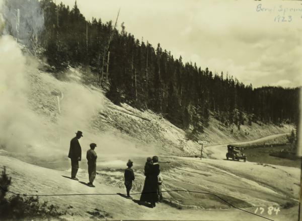
Visitors observing Beryl Spring from the side of the road in 1923, prior to the construction that breached its sinter cap and altered the spring’s characteristics/From the National Park Service archives, retrieved by M.A. Bellingham.
Many attempts were made to plug the new springs with concrete, but the repairs were no match for the hot, acidic gases. On September 18, 1942, the road caved in and formed a deep hole after multiple repairs had already been made earlier that summer. The road crew attempted to drain the water- and steam-filled hole into the Gibbon River by digging a trench lined with vitreous pipe, which resulted in a substantial flow of water that continued for days and caused the hole to enlarge significantly and the water level in Beryl Spring to drop.
Testing revealed that the water draining from the spring in the road was neutral but the steam was acidic, so ordinary rock and concrete were not a long-term solution. Instead, to fill the hole, park staff used obsidian boulders and mud from a dormant mud pot, because mud pots are naturally acidic environments.
On September 24, repair work began. Mud and rocks were deposited into the hole, but they disappeared immediately; the hole was measured with a pole and found to be at least 8 feet (2.4 meters) deep. Obsidian boulders were then dropped into the hole until they were visible—it took about three truckloads! Park engineers then dumped six truckloads of clay on top of the boulders, only for it to sink through and disappear almost immediately. The water rose throughout the day until it was within 10 inches (25 centimeters) of the surface of the pavement that evening. But by the following morning, the hole had drained and was only steaming. The hole was filled with more clay, and a bridge was constructed across the area to prevent the road from collapsing in other areas.

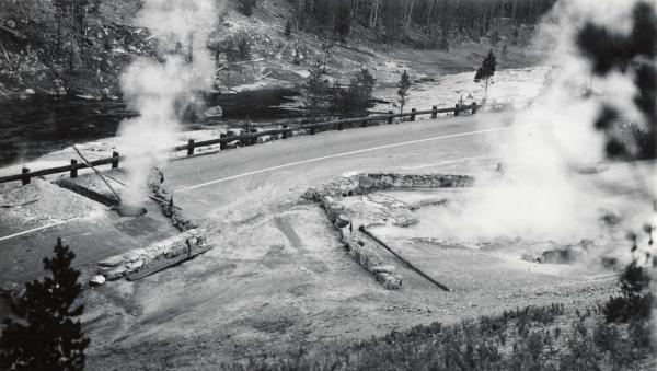
Beryl Spring is a hydrothermal area in some restrictive topography! The road from Norris Geyser Basin to Madison Junction follows the Gibbon River through a tight valley. With not much of a choice, the road threads between the river and Beryl Spring over some exceedingly hot ground. It takes a feat of engineering to keep the road drivable through this area, and sometimes nature has the final say, as in 1942, when this National Park Service photo was taken. Don't fret, the road is now passable by auto and bison/NPS file
Due to recurring issues on this section of road, the National Park Service partnered with the Bureau of Public Roads (BPR) to fix the road, with Robert O. Fournier from the USGS as a consultant. Planning and construction began in 1962. BPR engineers decided that the best course of action would be to dig a 4-foot deep and 10-foot wide (1.2 by 3 meters) trench between Beryl Spring and the road and fill it with "impervious clay" to stop what they assumed to be a shallow seep of water, even though digging through the crust of the spring was what originally caused the issues. They also wanted to plug the 1942-era road springs with concrete, as had been attempted before without success.
Fournier suspected that the springs were not connected via a surficial fracture because the spring in the road was hotter than the water at the margins of Beryl Spring and had a slightly higher pH, so he conducted a study to determine their relation. He measured the conductivity of both springs and then dumped 20 pounds of sodium chloride (salt) into Beryl Spring and periodically remeasured their conductivities. After 40 minutes, the conductivity of the water in the road spring began rising, indicating that there was a connection, but that it was deep underground. He argued against digging the trench proposed by BPR, stating that it would not fix the problem because the connection was at depth and the proposed work could have disastrous results.

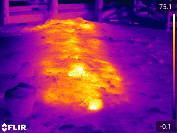
Thermal imagery from near Beryl Spring showing heat from a buried pipe that vents steam from the concrete containment box built in1962 around a spring that opened in the adjacent roadbed in 1942/NPS, Erin Dundas, November 8, 2023.
Fournier reported that the flow of hot water from beneath the road had increased after the 1959 earthquake and was emerging at a rate of about 34 gallons (124 liters) per minute through a drainpipe. The water level in Beryl Spring was below its historical level due to the draining, so he proposed a new solution to restore it to a more natural state. He suggested building a concrete containment box around the road spring so it could fill up deep enough to raise the water level in Beryl Spring and putting a lid on it that could vent steam away from the road and prevent acid buildup. This structure was found to be effective, and Beryl Spring returned to its natural state. A bridge was built over the whole area to avoid the recurring impacts from the thermal ground. Fournier’s 1962 containment structure is still functioning to this day.
Talk about your bridge over troubled water!
Acknowledgement: Thanks to M.A. Bellingham, who identified a number of letters and photos related to the history of Beryl Spring at the Yellowstone Heritage and Resource Center.


