Editor's note: Volcano Watch is a weekly article and activity update written by U.S. Geological Survey Hawaiian Volcano Observatory scientists and affiliates.
A pūpū platter is an assortment of appetizers commonly served at social gatherings in Hawaii. During one week in December 2023, Island of Hawaiʻi residents and visitors were treated to an assortment of earthquakes resulting from a variety of different geologic processes, like a pūpū platter of earthquakes!
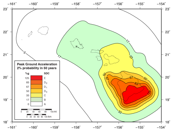
Seismic hazard across the State of Hawaii based on past earthquakes and corresponding ground shaking. Areas with high seismic hazards depicted with warm colors (red-orange) and relatively low seismic hazards depicted with cool colors (green). Quantitatively, the different colored-areas are defined by the maximum ground-motion acceleration (in percentage of gravity) over the next 50 years that have a 2% chance of exceedance. The southeast part of the Island of Hawai‘i has the highest expected ground acceleration (195 percent of gravity) that has a 2% chance of occurrence during a 50-year time period. For source data description, see Klein et al (2001) plus associated published online data.
Thousands of earthquakes occur every year in Hawaii. These earthquakes are monitored by the USGS Hawaiian Volcano Observatory (HVO) and fall into three main classes: volcanic, tectonic, and mantle.
Volcanic earthquakes are associated with magma moving within, and erupting from, active volcanoes. Tectonic earthquakes are associated with slippage along faults within the volcanoes, and along the décollement which separates the volcanoes from the underlying oceanic crust. Mantle earthquakes are associated with bending of the Earth's crust and upper mantle due to the weight of the islands above.
The first earthquake in our pūpū platter was a magnitude-5.1 event that occurred on Monday, December 4, 2023, at 5:54 p.m. HST. It was located 9 miles (14 km) southeast of Volcano at a depth of 1 mile (2 km) below sea level. This was a tectonic earthquake related to shallow movement on the pali system of Kīlauea volcano’s south flank. HVO received 1,180 felt reports from around the Island of Hawaiʻi and a handful from Maui, Oʻahu and even Kauaʻi islands. Fortunately, no damage was reported. A magnitude-3.1 aftershock occurred four minutes later.
A magnitude-4.4 event then occurred on Wednesday, December 6, at 5:17 p.m. HST. It was located 1 mile (2 km) west-northwest of Volcano at a depth of 14 miles (23 km) below sea level. It was likely a mantle earthquake related to flexing of the oceanic crust buried deep below the island. HVO received 383 felt reports for this event.
A magnitude-3.6 event then occurred on Thursday, December 7, at 7:13 a.m. HST. It was located east of Pāhala at a depth of 20 miles (33 km). The size, location and mechanism indicate that it likely was a mantle earthquake associated with the ongoing Pāhala seismic swarm. This event got 69 felt reports.
Two days later, two different earthquakes occurred within one minute of each other. A magnitude-3.6 event occurred on Friday, December 8 at 9:21 p.m. HST. It was located 2 miles (3 km) west-southwest of Hōlualoa at a depth of 8 miles (13 km) below sea level. This was likely a tectonic earthquake associated with slippage on a fault within Hualālai volcano. HVO received 464 felt reports, primarily from the Kona side of the Island of Hawaiʻi.
One minute later, a magnitude-3.4 event occurred 12 miles (19 km) north of Pāhala at a depth of 4 miles (7 km) below sea level. This earthquake was likely a tectonic earthquake associated with slippage on the Ka‘ōiki fault system between Kīlauea and Mauna Loa volcanoes on the Island of Hawaiʻi. There were 44 felt reports for this event.
A magnitude-3.1 event occurred on Monday, December 11 at 3:08 p.m. HST. It was located 13 miles (21 km) southwest of Laupāhoehoe at a depth of 19 miles (31 km) below sea level. It was likely a mantle earthquake related to flexing of the oceanic crust deep below Mauna Kea. This event had 29 felt reports.
In addition to the widely felt tectonic and mantle earthquakes above, more than 400 volcanic earthquakes occurred beneath the summit of Kīlauea from December 4 through 11, with a peak of more than 200 events on December 7. While numerous, these earthquakes were small and not felt. All were below magnitude-3.0 and most were below magnitude-2.0. These events were associated with the intrusion of magma beneath Kīlauea summit.


Add comment