Editor's note: Volcano Watch is a weekly article and activity update written by U.S. Geological Survey Hawaiian Volcano Observatory scientists and affiliates.
Ocean swells are constantly occurring across the Earth’s oceans. These swells interact with the ocean crust below, creating continuous ocean noise that travels all over the Earth, including through our active volcanoes here in Hawaii. Because ocean noise signals are always being generated, scientists can use these seismic sources to identify small changes occurring in the Earth’s crust over time.
In climates that experience all four seasons, scientists have shown that ocean noise travels through these regions faster in times when snowpack is present and slower in times when the snow has melted. This winter speedup is due to the overlying snowpack compressing the subsurface and closing any fractures below it.
When the snow thaws, the subsurface is no longer compressed, the fractures open again, and the snow melt percolates into these fracture systems. This causes ocean noise to travel through these regions more slowly in the spring and summer months. Similarly, in climates that experience excessive rainfall, such as Hawaii, such precipitation diffuses into the ground, opening fractures and cracks, and causing slowdowns in ocean noise propagation speeds.
Magma moving under active volcanoes can cause similar opening and closing of fracture systems resulting in changes in the velocity at which ocean noise signals travel through a volcano. Scientists at the Hawaiian Volcano Observatory are developing new techniques that utilize such velocity changes to understand what is happening beneath the surface of volcanoes on the Island of Hawaiʻi.

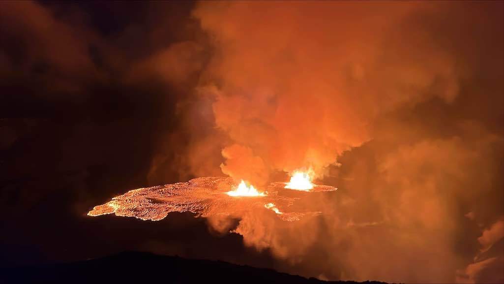
The figure shown here indicates changes in the velocity of ocean noise traveling through the summit region of Kīlauea volcano several months before, and in the month after, the start of the summit eruption in December 2020.
From September to mid-October 2020, the velocity of ocean noise in Kīlauea summit region remained fairly constant. However, by mid-October 2020, velocities in the summit region began to decrease rapidly. When magma migrates beneath the surface, it opens cracks and fractures in the region immediately above it. The opening of these fracture systems, as well as the influx of the magma itself, causes a slowdown in the propagation speed of ocean noise signals through that region.
Scientists at the Hawaiian Volcano Observatory have concluded that magma began to move from deeper depths beneath Kīlauea summit by mid-October 2020. By early December 2020, velocities began to decrease at a more dramatic rate suggesting a more rapid inflow of magma into Kīlauea summit. At that point, earthquake and ground deformation patterns beneath the summit indicated that a small intrusion of magma had occurred.
By mid-December 2020, the velocity of ocean noise traveling through Kīlauea’s summit decreased even more, indicating the continued invasion of magma into the volcano.
Finally, on December 20, 2020, at approximately 9:30 p.m. HST, the eruption at Kīlauea’s summit began. Following the onset of this eruption, as seen in the figure, a dramatic increase in the propagation speed of ocean noise signals through the summit region was observed. As magma was removed from the shallow storage reservoir, by the outpouring of lava, the region above it deflated. This deflation causes the closure of fractures within the shallow summit, and a resulting increase in the velocity of ocean noise through the summit.
This example demonstrates how monitoring for changes in ocean noise velocity could potentially be used to aid in forecasting volcanic activity. Hawaiian Volcano Observatory scientists are working to better understand this process and apply it as a real-time monitoring tool at both Kīlauea and Mauna Loa volcanoes.
Stories about:
Story Categories:
A copy of National Parks Traveler's financial statements may be obtained by sending a stamped, self-addressed envelope to: National Parks Traveler, P.O. Box 980452, Park City, Utah 84098. National Parks Traveler was formed in the state of Utah for the purpose of informing and educating about national parks and protected areas.
Residents of the following states may obtain a copy of our financial and additional information as stated below:
- Florida: A COPY OF THE OFFICIAL REGISTRATION AND FINANCIAL INFORMATION FOR NATIONAL PARKS TRAVELER, (REGISTRATION NO. CH 51659), MAY BE OBTAINED FROM THE DIVISION OF CONSUMER SERVICES BY CALLING 800-435-7352 OR VISITING THEIR WEBSITE. REGISTRATION DOES NOT IMPLY ENDORSEMENT, APPROVAL, OR RECOMMENDATION BY THE STATE.
- Georgia: A full and fair description of the programs and financial statement summary of National Parks Traveler is available upon request at the office and phone number indicated above.
- Maryland: Documents and information submitted under the Maryland Solicitations Act are also available, for the cost of postage and copies, from the Secretary of State, State House, Annapolis, MD 21401 (410-974-5534).
- North Carolina: Financial information about this organization and a copy of its license are available from the State Solicitation Licensing Branch at 888-830-4989 or 919-807-2214. The license is not an endorsement by the State.
- Pennsylvania: The official registration and financial information of National Parks Traveler may be obtained from the Pennsylvania Department of State by calling 800-732-0999. Registration does not imply endorsement.
- Virginia: Financial statements are available from the Virginia Department of Agriculture and Consumer Services, 102 Governor Street, Richmond, Virginia 23219.
- Washington: National Parks Traveler is registered with Washington State’s Charities Program as required by law and additional information is available by calling 800-332-4483 or visiting www.sos.wa.gov/charities, or on file at Charities Division, Office of the Secretary of State, State of Washington, Olympia, WA 98504.
INN Member

The easiest way to explore RV-friendly National Park campgrounds.

Here’s the definitive guide to National Park System campgrounds where RVers can park their rigs.
Our app is packed with RVing- specific details on more than 250 campgrounds in more than 70 national parks.
You’ll also find stories about RVing in the parks, tips helpful if you’ve just recently become an RVer, and useful planning suggestions.
