Editor's note: Volcano Watch is a weekly article and activity update written by U.S. Geological Survey Hawaiian Volcano Observatory scientists and affiliates.
At Hawai'i Volcanoes National Park, Kīlauea’s activity from 2018 until now has been compared to cycles of summit collapse and refilling prior to 1924. However, Kīlauea also exhibited similar behavior during the 1967-68 Halema‘uma‘u eruption.
We can learn about how the Hawaiian Volcano Observatory (HVO) monitored Kīlauea prior to and during the 1967-68 Halema‘uma‘u eruption by reading reports documenting activity at that time. HVO staff then wrote, “The current eruption in Halema‘uma‘u is especially interesting because events seem to be following the same general pattern that was recorded again and again during the pre-1924 Kīlauean activity.”
In March and December 1965, middle East Rift Zone eruptions occurred that partially drained the magma storage system at Kīlauea summit and caused modest subsidence. The 2018 lower East Rift Zone eruption of Kīlauea drained the summit magma chamber on a larger scale, resulting in caldera collapse.
Similar timeframes of quiet, non-eruptive periods ensued at the summit of Kīlauea following the 1965 and 2018 eruptions. About two years after each eruption, the summit magma reservoir recharged and eruptions occurred.
HVO staff wrote that the 1967-68 eruption was preceded by only about “one hour of gradually increasing harmonic tremor…though the eruption has been ‘expected’ for over a year.” Gradually increasing earthquake rates and inflation over the months prior signaled to HVO staff that an eruption could be coming.
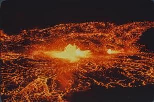
A telephoto image of vents erupting on the floor of Halema‘uma‘u crater, at the summit of Kīlauea, in 1967/NPS, C. Stoughton.
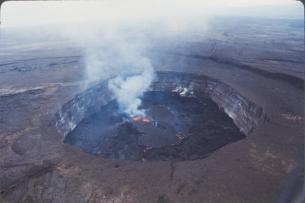
An aerial overview of Halema‘uma‘u crater erupting in early December 1967/USGS
Likewise, modern HVO has monitored increasing rates of earthquakes and ground deformation for weeks to months prior to the recent eruptions at the summit of Kīlauea. The immediate harbinger of these eruptions has occurred within a similar timeframe of about an hour, as ascending magma breaks rock and causes seismicity.
In 1967, HVO had 12 seismometers and two tiltmeters monitoring Kīlauea’s summit. Though the seismometers were telemetered to the observatory, the tiltmeters were done by hand, being read manually every two-to-twelve hours.
Today, HVO’s Kīlauea summit monitoring network includes similar numbers of seismometers (18) and tiltmeters (4), but it has expanded to include other monitoring datasets. For example, GPS stations record three-dimensional ground motion, gas-stations record volcanic gas emissions and other meteorological data, gravimeters track accumulation and loss of magma beneath the surface, a laser rangefinder tracks elevation of the crater floor, and webcams capture imagery (visual and thermal) documenting changes on the surface and eruptive activity.
Compared to the manual data monitoring of 1967, telemetry advancements and digitization allow HVO scientists to observe near real-time monitoring data remotely. Much of these data are available to the public on the HVO website, including the popular livestream camera.
In their 1967 eruption reports, HVO staff observed that “Halema‘uma‘u is in the process of being filled.” The eruption, which began on November 5, 1967, went on for another 251 days and filled about 370 ft of lava in the crater (113 m). Post-2018 eruptions within Halema‘uma‘u, which began in December 2020, September 2021, January 2023, and June 2023, continued for two weeks to over a year, and have filled the crater over 1,270 feet (387 m) in total.
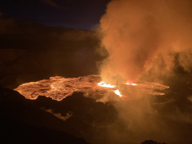
A telephoto image of vents erupting on the floor of Halema‘uma‘u crater, at the summit of Kīlauea, in June 2023/USGS
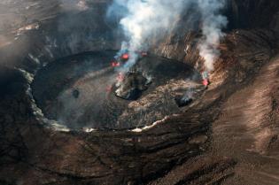
An aerial overview of Halema‘uma‘u erupting in late September 2021/USGS.
HVO staff today have seen similar improvements in monitoring and research, especially with funding supplied through the Additional Supplemental Appropriations for Disaster Relief Act of 2019 (H.R. 2157). Eruptions over the past several years, which include the several at Kīlauea summit and one on Mauna Loa, have certainly kept HVO staff busy, but have also provided unprecedented opportunities for learning and strengthening relationships with our partners and communities on the Island of Hawai‘i.
Similarities can be drawn between Kīlauea’s behavior prior to 1924 and discrete other periods, including the 1967-68 eruption and the 2018 summit collapse and subsequent refilling eruptions. These examples are a good reminder that a volcano’s past behavior can offer clues as to how it might behave in the future.
Volcano Activity Updates
Kīlauea is not erupting. Its USGS Volcano Alert level is ADVISORY.
Active lava has not been visible within Halemaʻumaʻu crater at the summit of Kīlauea since June 19. Earthquake activity in the summit region has been low over the past week. Summit tiltmeters generally showed gradual inflation for much of the past week. A sulfur dioxide (SO2) emission rate of approximately 104 tonnes per day was measured on July 17.
Mauna Loa is not erupting. Its USGS Volcano Alert Level is at NORMAL.
Webcams show no signs of activity on Mauna Loa. Seismicity remains low. Summit ground deformation rates indicate slow inflation as magma replenishes the reservoir system following the recent eruption. SO2 emission rates are at background levels.
There were five earthquake with three or more felt reports in the Hawaiian Islands during the past week: a M3.2 earthquake 21 km (13 mi) N of Hawaiian Ocean View at -1 km (0 mi) depth on July 18 at 11:24 p.m. HST, a M3.2 earthquake 10.1 km (6.2 mi) NE of Pāhala at 31 km (19 mi) depth on July 16 at 12:56 a.m. HST, a M3.0 earthquake 12 km (7 mi) N of Puako at 20 km (12 mi) depth on July 13 at 7:56 p.m. HST, a M1.8 earthquake 14 km (8 mi) ESE of Pāhala at 31 km (19 mi) depth on July 13 at 12:38 p.m. HST, and a M4.6 earthquake 97 km (60 mi) NNE of Laupāhoehoe at 28 km (17 mi) depth on July 13 at 11:29 a.m. HST.

