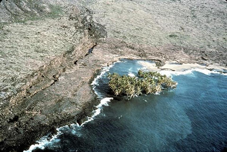
A submerged coconut grove at Halapē, Hawai'i Volcanoes National Park / Public Domain
Traveler’s note: Volcano Watch is a weekly article and activity update written by U.S. Geological Survey Hawaiian Volcano Observatory scientists and affiliates.
For decades, officials from the Pacific Tsunami Warning Center and International Tsunami Information Center, along with the Pacific Tsunami Museum, and other government officials have used April for a month-long campaign to educate the public on recognizing and mitigating hazards from tsunamis, a series of waves generated when a large volume of ocean water is displaced.
The Hawaiian islands are situated in the middle of the Pacific Ocean—a giant body of water surrounded by a long chain of volcanoes (also known as the Ring of Fire) along the edge of five continents. These volcanoes exist because the Pacific plate is subducting (moving beneath) other tectonic plates – gigantic pieces of oceanic and continental crust. These subduction zones, where tectonic plates converge or come together, are where very large (megathrust) earthquakes typically happen. A more recent example of such an event is the M9.1 Tōhoku earthquake that occurred near Japan in 2011; it caused an 18 ft (5 m) run-up in Hawaii a few hours after the earthquake.
Tsunamis that hit Hawaii don’t always come from distant earthquakes. Although not as frequent, tsunamis can also be generated by underwater volcanic eruptions. A very recent example of this is the Hunga-Tonga Hunga-Haʻapai eruption in 2022. The volcanic plume in January 2022 rocketed 36 mi (58 km) up, above sea level, and was the largest volcanic blast ever recorded by modern instruments. This event caused 60 ft (20 m) run-up on local nearby islands, but only a small, but measurable, tsunami on Hawaiian shores.
Fortunately, Hawaii is far away from subduction zones and explosive volcanoes—though Kama‘ehuakanaloa (formerly Lō‘ihi Seamount) and other Hawaiian volcanoes sometimes produce small explosive eruptions. The population of Hawaii has a few hours to react if a distant megathrust earthquake or catastrophic volcanic eruption causes a tsunami that crosses the Pacific.
Unfortunately, Hawaii can generate tsunamis locally. Such was the case on November 29, 1975, when a M7.7 earthquake was generated under Kalapana due to the south flank of Kīlauea abruptly sliding farther southeast towards the ocean. The strong local earthquake caused millions of dollars in property damage, and the subsequent tsunami took two lives at Halapē (a coastal camping location on the south flank of Kilauea in Hawai'i Volcanoes National Park) and caused additional property damage with a maximum run-up of 47 ft (14 m).
Locally-generated tsunamis are why Hawaiians must always be prepared. A local tsunami strikes fast and with little time for people to react. Devastating waves can travel across the Hawaiian island chain in minutes, and not just in the month of April. If there is a strong earthquake and you are at a location along the coast, “Don’t Fool Around. Get to High Ground!”
This article is about tsunami awareness around Hawaii, but the effects of a tsunami may be felt by anyone living or visiting other coastal areas around the world. To learn more about tsunami preparedness, visit the International Tsunami Information Center website (http://itic.ioc-unesco.org). If you happen to live or be visiting Hilo, Hawaii, on Saturday, April 22nd, then you may attend a free tsunami and hazard preparedness workshop at the Pacific Tsunami Museum in Hilo from 1:00 – 4:00 p.m.

