Editor's note: Yellowstone Caldera Chronicles is a weekly column written by scientists and collaborators of the Yellowstone Volcano Observatory. This week's contribution is from Michael Poland, geophysicist with the U.S. Geological Survey and Scientist-in-Charge of the Yellowstone Volcano Observatory.
Indigenous North Americans have long known of the wonders of Yellowstone. Archaeological evidence shows that humans have been in the region for at least 11,000 years. Tools made from material quarried from Yellowstone’s Obsidian Cliff have been found as far east as Ohio and Ontario, and many tribes, like the Kiowa and Shoshone, have origin myths centered on Yellowstone. But it was only in the 1800s that the first Euro-Americans visited the area.
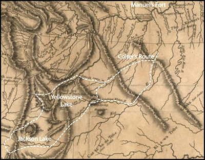
William Clark's 1814 map, indicating the route of John Colter during the winter of 1807-1808. (Library of Congress, Geography and Map Division, Washington, D.C.)
William Clark passed by the area in 1806 during the Corps of Discovery’s return to St. Louis from the Pacific Northwest. He and Merriweather Lewis split the group to explore more of the region, and Clark’s route took him through present-day Livingston and to the Yellowstone River, but he did not explore south to the river’s source. In his journal, published several years later, Clark stated that that Indigenous people were afraid of the area at the head of the river because of “loud noise, like Thunder, which makes the earth Tremble.” This is an odd statement, given that in 1805 the Governor of Louisiana Territory described a map drawn on a bison hide by an Indigenous American showing a “volcano” on the Yellowstone River. Obviously, Indigenous people were never afraid of Yellowstone, but that myth has proven persistent.
Even though Lewis and Clark didn’t see the area that is now Yellowstone National Park, one of their companions did. John Colter left the Corps of Discovery before its return to St. Louis to join other trappers working in the Rocky Mountains. In the winter (!) of 1807–1808, Colter traversed the Yellowstone and Teton areas, probably becoming the first Euro-American to see thermal features like Mud Volcano, although it seems that he missed features like Old Faithful and Grand Prismatic Spring. A carving in a tree discovered in 1881 near the Grand Canyon of the Yellowstone, “J.O.R. AUG. 29, 1819,” suggests that there were also Euro-American visitors in the 1810s.
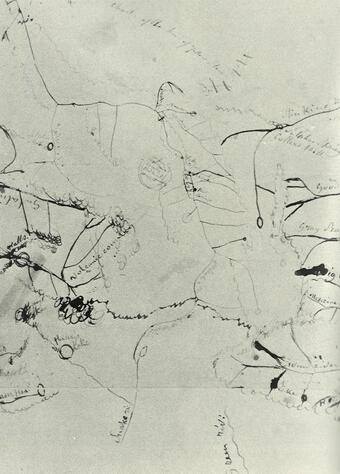
The Bridger-DeSmet map, drawn in 1851. It marks a volcanic region in the heart of Yellowstone/Courtesy of Saint Louis University.
No organized explorations of the area that is now Yellowstone National Park were successful until the 1860s. In 1863, prospectors led by Walter deLacy entered the region from the south, making their way from the Snake River to Shoshone Lake, over the Continental Divide, down the Firehole River, past the major geyser basins, and to the Madison River, which they followed out of the area to the west. deLacy mapped the journey, publicizing the existence of the geyser basins. More prospectors followed, and the legend of the region continued to grow.
Three men from the Territory of Montana, David E. Folsom, Charles W. Cook, and William Peterson, explored the region in September 1869, bringing back yet more stories of Yellowstone’s magnificence — not all of which were believed. Cook sent an account of the journey to Lippincott's Magazine and received the response, “Thank you but we do not print fiction.” But the word was out among residents of Montana Territory, and in 1870 a more thorough expedition was led by Nathaniel Langford, Lt. Gustavus Doane and a detachment of soldiers, and Henry Washburn. One of the more noteworthy anecdotes of this trip was the stranding of one of the expedition members, Truman Everts, who became lost and was left for dead by his companions. After 37 days, Everts, barely alive, was located by rescuers who may have been motivated by promise of a reward — one that was ever paid, since Everts claimed he would have eventually made it out of the wilderness by himself.
Finally, in 1871, a federally funded exploration was mounted, this one led by geologist Ferdinand Hayden. The Hayden expedition, which included photographer William Jackson and artist Thomas Moran, undertook numerous scientific explorations — including the mapping of Yellowstone Lake and detailed investigations of the geysers and hot springs of the Upper, Midway, and Lower Geyser Basins. It was on the basis of Hayden’s account and his encouragement (and that of others) that Yellowstone National Park was created the following year.
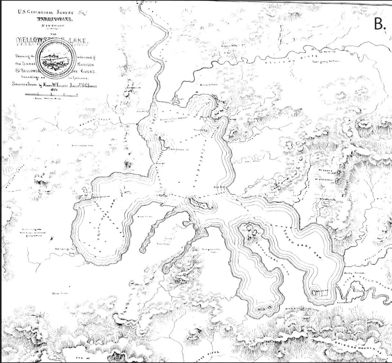
Henry Elliott’s 1871 map of Yellowstone Lake. The headwaters of the Snake River, Upper Valley of the Yellowstone River, and Pelican River are shown. The area now known as West Thumb is referred to as the South West Arm on the map. About 300 lead-sink soundings of lake depth were taken in this survey; most locations where soundings were obtained are marked on this map (depth in feet). Also shown are several of the places where the Hayden survey camped as they traversed around Yellowstone Lake.


Add comment