
It was a rumbling year at Yellowstone National Park in 2021/Rebecca Latson file
Editor's note: Yellowstone Caldera Chronicles is a weekly column written by scientists and collaborators of the Yellowstone Volcano Observatory. This contribution is from Michael Poland, geophysicist with the U.S. Geological Survey and Scientist-in-Charge of the Yellowstone Volcano Observatory.
It was business as usual in 2021 at Yellowstone—earthquakes, ground deformation, geyser eruptions, and lots of field work! As is tradition, this first Caldera Chronicles of the new year takes a look back at what happened in Yellowstone during the previous 12 months.
Yellowstone is a very active place in terms of seismicity. Typically the University of Utah Seismograph Stations, which is responsible for the operation of the Yellowstone Seismic Network and analysis of seismic data, locates 1500–2500 earthquakes every year in the region. The past three years have seen earthquake activity on the lower end of that spectrum, with fewer than about 2000 located earthquakes in 2018, 2019, and 2020 (in 2019 there were only about 1200 located seismic events!).
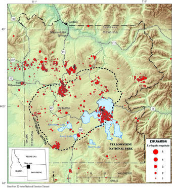
Map of seismicity (red circles) in the Yellowstone region during 2021. Gray lines are roads, black dashed line shows the caldera boundary, Yellowstone National Park is outlined by black dot-dashed line, and gray dashed lines denote state boundaries/Public domain.
The vast majority of Yellowstone earthquakes are very small—over 90 percent are in the range of M0–2. In 2021, there were 10 M3 events located in the Yellowstone region, and over 150 M2 events. These numbers are pretty typical for Yellowstone in a given year. The abundant seismicity is caused in large part by groundwater interacting with existing faults—two things that the Yellowstone region has in abundance!
GPS data did not detect any significant changes in surface deformation over the course of the year. Data from the caldera showed that the region continues to subside, as it has since 2015. Each summer, that subsidence pauses and may even turn to a slight amount of uplift as runoff from spring snowmelt percolates into the ground, which soaks up the water like a sponge.
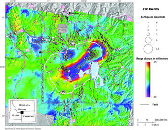
Interferogram created from data collected on September 22, 2020, and September 17, 2021, by the Sentinel-1 satellite system. Colored fringes indicate a change in distance (called range change) between the satellite and ground surface that is caused by surface deformation. In this interferogram, the fringes indicate subsidence (an increase in the range between the ground and the satellite) of as much as 3 centimeters (slightly more than 1 inch) in the central part of Yellowstone Caldera, and uplift of about 1.5 centimeters (less than 1 inch) of a small area south of Norris Geyser Basin during the period spanned by the images. White circles show earthquakes that occurred during the time spanned by the interferogram. Circle size scales with magnitude, with the largest about magnitude 3.6/Public domain
Geyser activity was relatively muted in 2021 compared to previous years. Steamboat Geyser, the world’s tallest active geyser, had 20 major water eruptions during the year. While impressive given that the geyser often experiences years to decades of very few eruptions, this number pales in comparison to 2018, when there were 32 eruptions, and 2019 and 2020, each of which had 48 eruptions. The decrease in the rate of Steamboat Geyser eruptions may reflect a gradual waning in activity. Hopefully the geyser will continue to put on a show in 2022!
Yellowstone Volcano Observatory scientists remained busy throughout the year, conducting experiments, analyzing data, deploying new instruments, and mapping geologic deposits. Of special note was the installation of a continuous gas-monitoring station in the Mud Volcano area in July 2021. This new station—the first of its kind in Yellowstone, and with real-time data available on the YVO website—continuously measures the concentrations of the four gases most commonly emitted by volcanoes: H2O, CO2, H2S, and SO2. Initial results show that the gases in the area are dominated by water vapor (~92-93 percent) and CO2 (~7-8 percent, at concentrations about twice the level of normal air), with only ~0.02% H2S and no SO2. This is consistent with results from other areas of Yellowstone.
Other field work included the seasonal deployment of GPS stations, mapping hydrothermal explosion and glacial deposits, maintaining and upgrading monitoring stations, collecting samples for geologic age determinations, sampling water and gas chemistry, and measuring seismicity associated with geyser activity in the Norris Geyser Basin and Upper Geyser Basin.
While 2021 was yet another productive year for YVO, we are happy to see the year come to a close, and we hope that 2022 will offer a brighter future for us all. YVO scientists and agencies will continue to monitor activity in Yellowstone National Park and report noteworthy activity and new research results in future editions of Yellowstone Caldera Chronicles. Stay tuned!


Add comment