Whether you're a veteran of years of national park travels, or a newbie setting out with an empty national parks passport, there always seems to be new destinations to explore. With this year's crowds at Yellowstone, Yosemite, Grand Canyon, Acadia and Grand Teton in mind, here's a handful of park system units sure to please without the jostling.
View of Tule Springs Fossil Beds National Monument/NPS
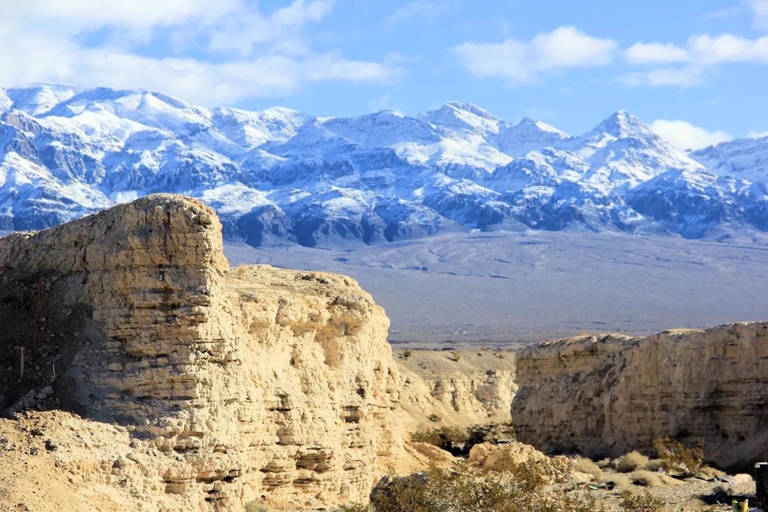
Tule Springs Fossil Beds National Monument, Nevada
When Tule Springs was added to the National Park System by an act of Congress late in 2014, it provided a window into the last Ice Age in the present-day desert outside of Las Vegas. It’s hard to imagine that camels, lions, and mammoths once roamed this landscape, but such was the case during the latter part of the Pleistocene era, which spanned a period of time between 11,000 years and 2.5 million years ago. The area-- known as the Upper Las Vegas Wash –- is rich with the fossils of these and many more creatures as well as ancient plants and pollens.
When it was added to the park system, Vince Santucci, the National Park Service's lead paleontologist, said "Tule Springs is a nice example that contributes to filling the gaps. What I mean by that is that prior to Tule Springs, we did not have a National Park Service unit dedicated to specifically preserving and interpreting a park for Ice Age, or Pleistocene, paleontology. And now Tule Springs provides that."
What makes Tule Springs so interesting largely are the fossil records that have been deciphered so far and which point to long-extinct Camelops, American lions that weighed half-a-ton, Dire wolves, saber-toothed cats, and horses that would be described as miniatures today. There were bison that were ancient relatives of those that graze in Yellowstone National Park today, mammoths, and ground sloths. Fossil remains from a period ranging from 200,000 years ago to 7,000 years ago are among the paleontological stories to be coaxed out of the ground.
The stories to be told in ongoing research at Tule Springs also relate to one of today's much-debated topics: climate change.
"What we see in the Pleistocene is most recognizable to the American public in terms of what they already know about modern organisms and their distribution. But of course, we lost some very important organisms at the end of the Ice Age: the mammoth, the saber-tooth cat, the camel, the horse, the sloth and other organisms," Santucci said back in 2015. "A lot of that story is related to climate change, and so since climate change is such an important buzz word these days, and it's an important concept for us to recognize. The stories and the values that we can gain from understanding that transition from the Pleistocene into the Holocene, the recent, and the associated climate change stories are very, very important ones, because we see adaptation of organisms across the landscape by virtue of shifts in their geographic location, their bio-geographic location as they move across the continent.
Nicodemus National Historic Site, Kansas
A story of rebirth and salvation is told at Nicodemus, which was put on the map in 1877 by a small group of formerly enslaved African Americans from Kentucky who settled here on the prairie at the end of the of post-Civil War Reconstruction.
Attracted to Kansas because of that state's decision to side with the Union during the Civil War, the settlers established the first Black community west of the Mississippi.
"... a Kansas Freedman's Association welcomed thousands of black refugees during the 'Black Exodus' of 1879, saying — the state had 'shed too much blood for this cause now to turn back from her soil these defenseless people fleeing from the land of oppression,'" the National Park Service notes.

The Town Hall at Nicodemus/NPS
Though the vision lasted only until the Dust Bowl days of the 1930s, when the pull of cities lured away many of Nicodemus's residents, at one point the community numbered several thousand. According to the National Park Service, "it was not until 1886 that the local agricultural economy was prosperous enough to support a permanent population of 200 residents. Nicodemus boasted a bank, four general stores, three groceries, four hotels, three pharmacies, two millineries, two liveries and two barber shops along with other businesses."
Some of those structures remain today: The Township Hall, St. Francis Hotel, First Baptist Church, African Methodist Episcopal Church, and District No. 1 School. Unfortunately, just two of those buildings -- Township Hall and the AME Church -- are fully open to the public.
What, along with the Dust Bowl, doomed the community was the decision in 1888 not to run the rails of the Union Pacific Railroad next to the town. That was a costly decision for the town's economy.
Though a unit of the National Park System, Nicodemus has not enjoyed the fruits of that status. As Traveler correspondent Robert Pahre noted in 2013, "[U]nfortunately, it seems that Congress and NPS budgeters would rather pay consultants to write reports than spend the money to follow up on their recommendations. These closed pocketbooks do a real disservice to the place. It may have lousy facilities, but Nicodemus has friendly staff who tell its stories well. The park tries to greet every visitor with a 15-minute orientation talk.
"The ranger will meet you in the Township Hall, rented from the local government. The inside of the hall looks like a high-school auditorium. It’s used for many community events, so the exhibits are built to be moved out of the way when necessary," wrote Pahre. "Visitors read signs on fold-up screens and watch a brief film on a television tucked over in one corner. The immediate, personal service puts a nice gloss on the site, but the physical environment is woefully inadequate for both visitors and staff. It’s also understaffed, with only one ranger and one guide. If either of them get sick or take a vacation, the other has to do everything."
So why visit? Nicodemus tells an important story of the struggles and determination of a small group of African Americans at the end of the of post-Civil War Reconstruction. Its story should resonate with those interested in the history of African Americans. And who knows, greater visitation just might encourage the Park Service to make a greater investment in Nicodemus. If not, as Pahre asked in his story, "it’s a mystery why (Congress) bothered to preserve the site in the first place."
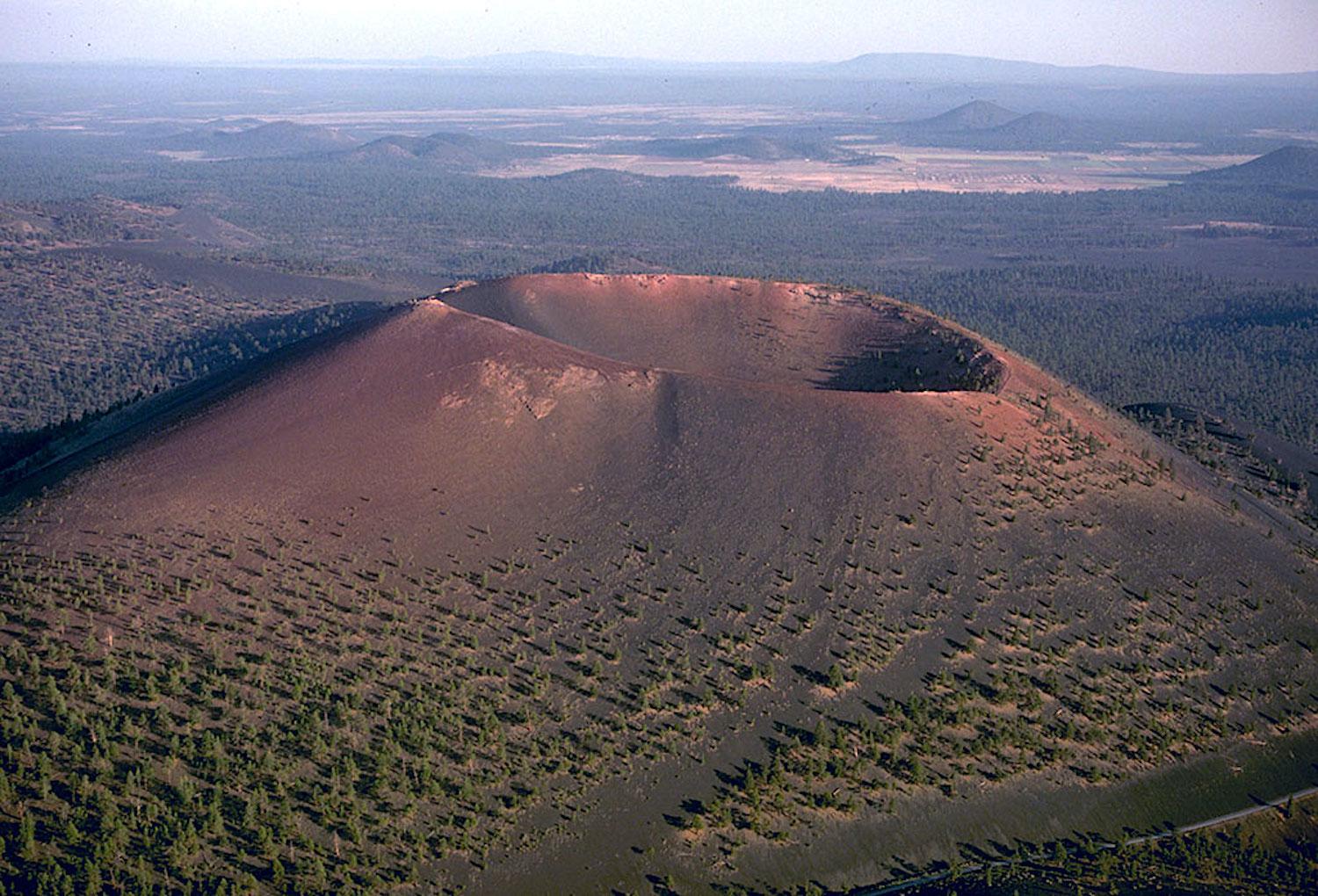
Sunset Crater's cinder cone/NPS
Sunset Crater Volcano National Monument, Arizona
Geology, volcanics, and Indigenous cultures all provide narratives when you try to understand this landscape in northern Arizona not far from Flagstaff.
From the loop road that veers off of U.S. 89 to Sunset Crater (and on to Wupatki National Monument), this monument seems little more than a patch of lava field with an extinct volcanic cone in the distance. Sunset Crater was designated a national monument on May 26, 1930, by President Herbert Hoover after a movie company proposed to blow up a this unique geologic area.
For hikers, much of the rocky terrain is sharp, brittle, and unforgiving. Head to the Lava Flow Trail and you’ll find a self-guided, one-mile trail. Other options include two trails that leave the Lenox Crater trailhead. The Lenox Crater Trail is a one-mile, steep trail, and the Aa Flow Trail winds a quarter-mile through the lava flows.
But pause for a moment, and let me intrigue you enough to stop for more than a hike.
Sunset Crater is part of the San Francisco Peaks volcanic field. It is one of an estimated 600 cinder cone volcanoes once powered by a maze of magma plumbing flowing out from the San Francisco Peaks, which are the remnants of a stratovolcano. Sunset Crater is the youngest of the volcanoes in the 1,800-square-mile volcanic field.
At the time it erupted, the landscape was a more bucolic setting, with the Sinagua culture cultivating fields of maize and living in pithouses.
"Long time ago the ground trembled, a big black smoke came,” was the memory the Hopi passed from generation to generation. It was a thick, choking, even poisonous smoke, preceded no doubt by shuddering earthquakes and precipitated by a furious, explosive eruption that alternately darkened and lit up the sky for hundreds of miles around.
Where only fields of maize and surrounding pithouses on the edge of a pine forest had stood, there suddenly was a growing, fuming, and sputtering cinder cone in a landscape dotted by hundreds of much older cinder cones that stood in silence. Palatsmo was not silent, and it tore at the land. A lava fountain possibly 2,000 feet tall was spit out of the earth.
Elizabeth Brandt was able to capture a bit of the setting in 1997 when she wrote the Anthropological Literature Review and Annotated Bibliography for Sunset Crater Volcano and Wupatki National Monuments:
... flames and the glow of hot lava issuing forth from such beds continued to confirm early Hopi legends that this land belonged to their Fire God, Masauu, who was also the god of the surface of the earth, from whom they inherited the land and with whom they have a covenant to care for it.
Today you can explore the lava beds around Sunset Crater and the monument's other cinder cone volcano, Lenox Crater. During the summer season rangers often lead hikes on the Lava Flow Trail; check with the park to see if the hikes are being held. The park also has been certified as an International Dark Sky Park, making it a great destination for staring into space.
Grant-Kohrs Ranch National Historic Site, Montana
When the brutally cold and snowy winter of 1886-87 swept through the Rockies, it crippled many of the West's cattlemen. For Conrad Kohrs, however, his banker in nearby Butte, Montana, provided him with a $100,000 handshake loan that enabled him to rebuild the largest cattle empire the country has ever known.
How big? Kohrs expanded the ranch started by Johnny Grant, a trapper-turned-cattleman, immensely. Based just outside Deer Lodge, Montana, Kohrs fed his cattle on the open range in four states and two Canadian provinces. Part of his 10 million acres included a 30,000-acre home ranch near Deer Lodge. From that ranch he began shipping cattle to market in 1883 via a Utah Northern Railroad (later acquired by Northern Pacific) siding that ran through the spread.
So successful were his operations that Kohrs expanded the original 4,000-square-foot ranch house to a sumptuous 8,800-square-footer for his wife, Augusta, decorated it lavishly, and took his family on European vacations.

Conrad Kohrs, here with friends in his mansion, turned the deadly blizzard of 1886-87 into a fortune/NPS archives
The ranch ran a variety of cattle -- purebred Longhorns, Shorthorns, and Herefords. The latter two breeds were added because they endured Montana's harsh seasons more easily than the Longhorns. More importantly, they put weight on faster.
Today the ranch is a much, much smaller spread, spanning just 1,600 acres, but it retains a rich and fascinating collection of late-19th century cattle baron memorabilia. While the sprawling ranch house is a magnificent structure frozen in time from the heydays of the Kohrs empire, outbuildings that housed a blacksmith shop, bunk houses for hired hands, ice storage, and stables tell stories of what many today view as a romantic chapter of Western history but which in truth reflect the harshness of cowboy life.
When I visited, a signature triplet staccato rang sharply across the ranch compound from the smithy's anvil in the blacksmith shop, signaling another creation from fire and iron. A self-taught smithy, Lyndel Meikle hammered out a hoof pick in minutes, then offered a slice of lodgepole pine tree trunk bearing the ranch's G-K brand even quicker.
Meikle is retired these days, but visit the ranch and you just might be able to gain a hoof pick or ranch brand on a slice of pine that serves nicely as a coaster, or perhaps even a cup of cowboy coffee.
Salem Maritime National Historic Site, Massachusetts
It was late in the 18th century when the upstart United States turned to the open seas to support its growing economy.
From tiny Salem, Massachusetts, up the coast from another Massachusetts seaport that soon would become known as the whaling capital of the world, ships set out to navigate the globe and return home with spices, water buffalo hides, silks, and porcelains.
Visit this national historic site and you can see a floating remnant of that commercial enterprise, the Friendship of Salem. The three-master headed to sea in 1797 for the Salem-based mercantile concern of Waite and Peirce. But the venture was relatively short-lived, as the Friendship made just 15 voyages, to distant ports in Batavia, India, China, South America, the Caribbean, England, Germany, the Mediterranean, and Russia, before she became a prize of war during the War of 1812.
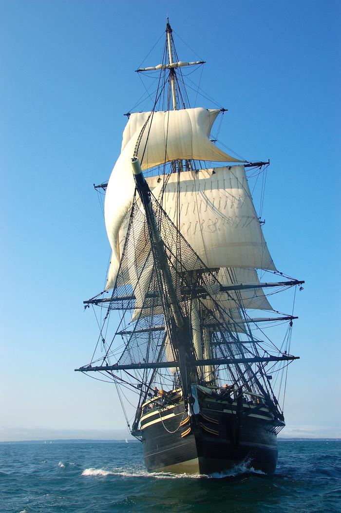
The Friendship of Salem under power/NPS
Though it's uncertain what happened to the original Friendship after the British auctioned her off on March 17, 1813, her spirit resurfaced in 1996 when a reproduction of her keel was laid by Scarano Brothers Shipyard, and in 1998 when her hull was launched.
But the Friendship is not the only aspect of this 9-acre unit of the National Park System, which tells some of the country's early seafaring history.
According to park historians, "Salem was a vital part of British colonial trade as early as the mid-17th century. Dried cod and timber were taken from Salem to British plantations in the West Indies, and molasses, sugar and rum were then traded for fine and exotic goods in England."
Spend a little time here and you can tour the ship when it's in port, stroll wharves that date to the 1700s and 1800s, explore the Custom House where taxes were paid on cargoes as well as the West India Goods Store where coffee, tea, spices and silk brought to port were sold. There's also the Narbonne house, a modest, middle-income home dating to the late-1600s, and the home of merchant E.H. Derby, a wedding present given to him and his bride in 1762.
Valley Forge National Historical Park, Pennsylvania
Winter arguably is the only time of year to visit this encampment along the Schuylkill River.
The summer and fall of 1777 had been a terrible time for General George Washington and his Colonial army. Failed attempts to defend Philadelphia from the British forced the army to withdraw to a site for a winter encampment. The soldiers had little food, boots and clothing for many were in tatters, other staples were in short supply, and they had no shelter from the bitter winter which was now upon them.
One history of the era notes that, "Conditions were so severe at times that General Washington wrote, 'that unless some great and capital change suddenly takes place... this Army must inevitably... starve, dissolve, or disperse, in order to obtain subsistence in the best manner they can.'"
Against such dismal odds, Washington's army arrived at Valley Forge on December 19, 1777, seeking a place to survive and regroup. It did both, in one of the most dramatic and inspiring stories from the American Revolution. But there was, of course, a less savory side to the stories. Dr. Harold Selesky, author of the Encyclopedia of the American Revolution: Library of Military History and other publications and books related to the Revolutionary War, studied deserters from the Continental Army through newspaper listings of the men. He discovered that more than a few of the men were "fond of strong liquor."
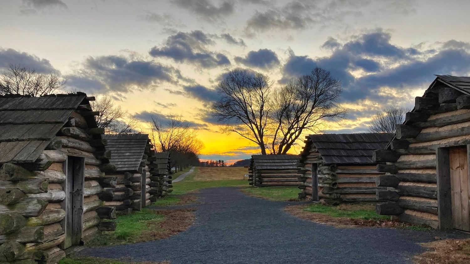
Replica huts of Muhlenberg's Brigade at Valley Forge/NPS, Gregory Purifoy
But visit Valley Forge in the coming months and you'll be able to gain some appreciation for the harsh conditions they endured. You can drive the Encampment Tour route, a 10-mile loop comprised with nine stops, including one at the Muhlenberg's Brigade that features nine reconstructed soldier huts. There on weekends in 2022 you just might find rangers and volunteers dressed in 18th-century attire and who can tell of the hardships the Colonials faced at Valley Forge that winter.
Washington himself noted the hardships in his diairies. In April 1778 that to see "... men without clothes to cover their nakedness, without blankets to lie upon, without shoes...without a house or hut to cover them until those could be built, and submitting without a murmur, is a proof of patience and obedience which, in my opinion, can scarcely be paralleled."
Salinas Pueblo Missions National Monument, New Mexico
Salinas Pueblo Missions, though having been established by presidential proclamation on November 1, 1909, is not one that often turns up when talk about exploring the National Park System is raised.
As Professor Bob Janiskee noted back in 2008, the monument originally was designated Gran Quivira National Monument in recognition of the park’s best known ruin. However, it acquired its present name through redesignation on 28 October 1988.
Salinas Pueblo Missions is situated east of the Manzano Mountains in the Estancia Basin of central New Mexico where it preserves the best existing examples of the 17th century Spanish Franciscan mission churches and convents built in this country at about the same time that the Pilgrims arrived in New England. Preserved in this unit are the ruins of four of America’s six remaining 17th-century Spanish mission churches as well as the ruins of three of the largest Pueblo Indian villages.
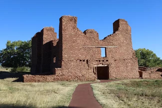
Front entrance of the church ruins at Quarai/NPS, Park Guide Alex Arnold
Growing public awareness and concern about climate change has highlighted a facet of the Salinas Pueblo Missions story that deserves much more attention that it has heretofore received. The stark truth is that the missions and pueblos that this park commemorates were abandoned because a drought of extraordinary ferocity and duration made life unbearable for the Spanish and the Indians throughout the Salinas Jurisdiction. The region’s once-thriving Native American communities and the Spanish missions established there at such great sacrifice withered and died. Explorers entering the region after the late 1670s found it utterly depopulated.
An equally interesting aspect of a visit to Salinas Pueblo Missions is the Lady in Blue.
Who was the Lady in Blue? Sôr María de Ágreda. She was an early 17th century Spaniard who, according to the park staff, "is reported to have experienced a period of bilocations beginning in 1620."
"Sôr María revealed that while in a trance in her convent in Ágreda, Spain, she was also mystically present in New Mexico and other places in the present-day American Southwest and Mexico," say park historians. "While in New Mexico, Sor María reported that she had visited the Jumano Indians, encouraging them to visit the Spanish missions to ask that a missionary return with them to their pueblos and villages. By 1626, reports from New Mexico were relaying stories of Native Americans arriving at missions because a 'Lady in Blue' had told them to go and speak to the priests at those missions.
"One location said to have been visited by this 'Lady in Blue' was the pueblo of Las Humanas, now known as Gran Quivira. She was also reported to have repeatedly 'visited' a group of refugee Jumanos near the mission of Cuarac (Quarai). With the arrival of additional missionaries in 1629, Gran Quivira became a visita (satellite mission without a resident Father) of the Abó Mission."
There you go, seven overlooked gems from across the National Park System to add to your to-do list. And there are more to come...
Add comment