

Charles Wilkes stood on the lip of Kīlauea's summit crater after dark and was astonished by the scene playing out before his eyes.
"The streams were of a glowing cherry-red color, illuminating the whole crater around," Wilkes said of the lava squeezing through cracks in the crater's surface. "The large lake beyond seemed swelling and becoming more vivid, so that we expected very moment to see an overflow from it of greater grandeur. ... The sight was magnificent, and worth a voyage round the world to witness."
Wilkes was on a voyage around the world when he anchored the ships of his U.S. Exploring Expedition at Hilo, Hawaii, in December 1840. His voyage of discovery for the young United States that ran from 1838 to 1842 provided him and his scientists ample time to explore the Hawaiian islands and the two volcanoes on the Big Island - Kīlauea and Mauna Loa. The amazement they had gazing into Kīlauea, which Wilkes described as a "mighty laboratory of nature," has been shared countless times by the multitudes that have gazed into the crater to catch its pyrotechnical eruptions since Wilkes watched the show 181 years ago.
Indeed, it has become a nightly pilgrimage for today's visitors to Hawai'i Volcanoes National Park, including myself; not to lay offerings for Pele of Hawaiian mythology at the rim of the Halemaʻumaʻu Crater, but rather to capture her glowing essence and carry it away in photographs and memories.
My wife and I started our November visit to the national park after dark in a rental property not far from the historic enclave of Volcano, a sleepy town on the park's eastern border. Surrounded by dense rainforest alive with the sounds of nature, the home was definitely off the beaten path, located down a few roads that took us only a few minutes from Highway 11 but seemingly into the Big Island's outback. Immensely comfortable as it was, the highlight of the small, two-story house was the observation tower the owner had built up one side of the structure.
"Steve had wondered if he should build it," said Pono, the caretaker, as he led us up the wooden steps that lifted us to a small platform roughly 30 feet into the night sky, above both the home's roof and the surrounding rainforest.
There we were awestruck not by the Milky Way stretching from horizon to horizon high overhead, but by the red glow cast by Halemaʻumaʻu.
Molten Geysers
Few places on Earth allow you to gaze upon this planet's molten core as it seeps and sprays like glowing geysers through the crust. Lassen Volcanic National Park in northern California lets you check off four types of volcanoes – shield, composite, cinder cone, and plug dome – but they are all either extinct or dormant. Mount Rainier, though not yet extinct, is shrouded in snow and ice without a crater bubbling and bursting and fuming with lava.
The Kīlauea volcano, however, is very much alive and prone to long-running, though relatively meek, eruptions that can go on for years. It normally is one of the world's tamest portals into the Earth's molten basement, a fact that has made it one of the world's most studied volcanoes.
Wilkes, a conflicted mariner whose penchant for exploration and thirst for recognition were contrasted by a murderous demeanor that led to a slaughter of native Fijians and claims of mistreatment by his own men that led to his court-martial (but that's another story), and his team were not the first visitors to the Hawaiian islands to stand in wonderment before the volcano. A botanist who traveled with George Vancouver passed by Kīlauea in 1793 on his way up Mauna Loa, and in 1825 an English missionary, William Ellis, chronicled his 1823 visit to the volcano with interpretations of the volcanic activity he witnessed, as well as with stories the natives shared with him.
"The stories related to Ellis indicate that the caldera existed for 'many kings' reigns past,' interpreted as some 200–300 years before 1790," Donald Swanson, a U.S. Geological Survey volcanologist who headed the Hawaiian Volcano Observatory before retiring, wrote in a 2008 paper. "Those stories also tell of sporadic explosions from the caldera during that time."

Night-time Viewing Of Kīlauea's Eruptions Are A Main Draw Of Hawaii Volcanoes National Park/NPS, Janice Wei
The stories are age-old. According to another USGS study of Hawaiian lore, "Pele and her older sister Nāmakaokaha‘i, the eldest in a family of many siblings, were imbued with different powers—Pele reigned over volcanoes and eruptions; Nāmakaokaha‘i ruled the seas and beaches. Namaka, as she is known to friends, hated when Pele spread lava over beaches and intruded land into the ocean. Pele didn't appreciate Namaka trying to remove lava from the coasts. They fought frequently. We see these two sisters continuing to fight with spectacular explosive displays each time lava enters the ocean."
Although Kīlauea's eruptions, which started 50,000-70,000 years ago at least, have been blamed, in the case of the 1790 eruption, for 800 or more deaths (one report placed the fatalities at more than 5,400, though it's questionable), for the most part its activity generally is not the explosive type with incinerating pyroclastic flows. Instead, the shield volcano is one steadily built by subsequent mound-building flows. Kīlauea typically forces its molten rock through cracks in the earth and out across the landscape as gravity dictates. As a result, gazing into the Halema‘uma‘u Crater is the main attraction for many drawn to this national park.
Two days before my wife and I made an after-dinner trek down the Devastation Trail to watch the volcano's night-time activity, we stood on the rim looking into the crater with its simmering eruption. It was late morning, yet glowing fountains spitting from the crater were readily visible from our position a mile or so away; above them, a cloud of sulphur dioxide wafted.
"That's what daddy wanted to see last night, because in the dark time you can see it really good," one onlooker told her toddler as they gazed into the crater.
"Wow, that's beautiful," she added as a molten fountain crested above the growing cone within the crater.

Since eruptions resumed at Kīlauea in September, the fountaining has been a crowd-pleaser/NPS, Janice Wei
The next night, walking roughly a mile on a section of Crater Rim Drive that had been closed due to the 2018 eruption that took out a long section of asphalt, we were not alone. Guided by bobbing flashlights, headlamps, and even cellphone flashlights, dozens navigate the Devastation Trail after the sun slips beneath the rim of the Earth to reveal the stars’ pinpricks in the heavens overhead while giving Pele’s volcanic luminescence more resonance in the darkness.
As beams of light danced in front and behind us, we relied on the starlight along the trail. That was a small mistake, as we initially overshot the trail that led from the roadbed to an overlook the Park Service had created with rope lines, which some unfortunately decided shouldn’t prevent them from getting closer for a better photo. Doubling back, we found the trail, and like others, were like human moths drawn to Pele's glow. Around us the small crowd oohed and ahhed. Many forgot to disable their camera’s flash, which illuminated the foreground of stark vegetation and rocks, while obscuring, if only for a second or two, the eruption.
Though we stayed for less than a half-hour, we could now say for the rest of our lives that we had stood in the glare of an erupting volcano.
Not Just A Volcano
But Kīlauea's eruptions are far from the only reason to visit the national park. More than most other national parks, Hawai'i Volcanoes is anything but a static park. It’s constantly evolving, sometimes revealed only in the geologic rumblings that shudder through its basement, other times in exuberant eruptions, both fanciful and destructive.
According to the USGS, lava flows the past 1,000 years are responsible for the surface of the volcano we walked on. Back in 2018, Kīlauea was both fanciful and destructive as the volcano erupted for nearly four months. Beginning in May of that year and continuing into August, the park’s landscape was fractured in places by earthquakes, vegetation was engulfed in flames, and hundreds of buildings were either swallowed by lava flows or all but lost to seismic damage.

The 1959 eruption of Kīlauea Iki was said to produce some of the most spectacular eruptions of the 20th century, with molten fountains spouting 1,900 feet into the sky/USGS
Nearly 13 square miles of the island were covered by lava flows, which forced thousands to evacuate their homes; more than 700 homes were destroyed by streaming flows that made for dramatic nightly news imagery. After many months of quiet, the volcano resumed eruptions from December 2020 into May of 2021. This past September, the volcano again came to life, but not - so far - with the same vigor or destructiveness of the 2018 eruptions.
This volcanism, for many, is the essence of Hawai’i Volcanoes National Park. A crater of molten rock shimmering and sputtering. But as we explored the park, its landscape revealed numerous stories that match the eruptions' richness with history, culture, and natural resources.
One afternoon, following lunch in the Volcano House Hotel that provides panoramic views out towards Halemaʻumaʻu Crater, views that after nightfall can include Pele's flaming-red glowering, we headed down the Kīlauea Iki Trail. Starting from an overlook near the Thurston Lava Tube, which Native Hawaiians and now the park refer to as Nāhuku, the trail quickly took us down through the rainforest and deposited us on the crater floor of a volcano that last came to life in 1959 with one of the most spectacular eruptions of the 20th century at the national park. It was an eruption that saw lava fountains shoot roughly 1,900 feet into the sky and above Chain of Craters Road.
According to the National Park Service, "[A]lthough the Kīlauea Iki crater has completely solidified, magma continues to pulsate throughout the volcano. Geologically speaking, it is not unlikely that we may witness an eruption like this again."
Hiking the 3.3-mile loop at midday, as we did, probably isn't the best idea. High overhead a bright sun shined down, baking the black crater floor, and us. But the excursion was a great lesson in volcanic geology and for the afternoon separated us from the crowds back gazing into Halemaʻumaʻu in the crater next door.
The following morning with our one son and his wife we headed south along the not-quite-19-mile-long Chain of Craters Road, passing hardened lava flows that dated at least to 1969 when the Maunaulu eruption sent a stream of lava across the road. The landscape looked uncannily like an enormous pan of brownies, its rumpled surface cracked and etched.
Near road's end, we hiked out to the Puʻuloa petroglyphs left by ancient cultures. This roughly three-quarters-of-a-mile windblown walk brought us to a short boardwalk that circled hundreds of petroglyphs carved into lava outcrops. Via these etchings the Native Hawaiians documented their lives and culture. Among stick images of humans and sea turtles are cup-like depressions into which the Hawaiians would place the umbilical cords of newborns, a practice thought to help ensure a long and prosperous life.

Sea turtles are represented among the thousands of petroglyphs at Pu'uloa/Kurt Repanshek
A day later, as we ended our stay in the park and headed towards Kona via Highway 11, my wife spied the turnoff for the Mauna Loa Road, an 11.5-mile deadend route. Reversing course and turning onto the road, we were roughly following the route Wilkes and his team had taken in December 1840 to climb to the summit of 13,677-foot Mauna Loa.
"The very idea of standing on the summit of one of the highest peaks in the midst of this vast ocean, in close proximity to a precipice of profound depth, overhanging an immense crater ... would have been exciting even to a strong man, but the sensation was overpowering to one already exhausted by breathing the rarefied air, and toiling over the lava which this huge caldron must have vomited forth in quantities sufficient to form a dome sixty miles in diameter and nearly three miles in height," Wilkes noted in his journal.
What Wilkes couldn't appreciate was the submerged side of Mauna Loa, which last erupted in 1984. According to the USGS, this volcano's "long submarine flanks descend to the sea floor an additional 5 km (16,400 ft), and the sea floor in turn is depressed by Mauna Loa's great mass another 8 km (26,200 ft). This makes the volcano's summit about 17 km (55,700 ft) above its base!"
In short, this is the world's largest volcano.
Following the road as it threaded back-and-forth higher and higher through the heavily vegetated landscape on the lowest flanks (above the ocean) of Mauna Loa, I began to wonder if I made a mistake by not buying collision insurance for the rental. The road continued to narrow the higher we drove, and slowly lost much of its smoothness. When we encountered vehicles coming down from the top, one, or sometimes both of us, pulled halfway off the pavement and onto the grassy shoulder and slowly slipped by, hoping not to come away with some of the other vehicle's paint.
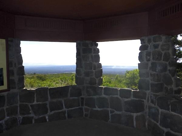
The view from the Mauna Loa Overlook towards Kīlauea/Kurt Repanshek
At road's end we snacked at the Mauna Loa Overlook, a small, rock-built pavilion with sweeping views towards steaming Kīlauea, listened to out-of-sight birds, and took a short hike to a patch where some rare silverswords, a threatened plant that grows nowhere else in the world outside of Hawaii's volcanoes, were said to grow. But without placards to point out the plants, which can live for half a century only to die after blooming, we weren't sure what we were looking at other than dried, desiccated vegetation.
Though the trail up to the summit, with one cabin 7.5 miles up the trail and another at the summit, beckoned, this was not the trip to set out to fully retrace the rough trail cut by Wilkes and his team.
As we returned to Highway 11 and headed west, it became clear to us that a week is not enough to fully explore Hawai'i Volcanoes National Park. We had barely touched the park's coastlines, and with more than 150 miles of trails there were many lines on the park's maps that we hadn't had a chance to follow into the rainforest or across the two volcanoes. Also left begging was our knowledge of Native Hawaiian history and culture, fuzzy areas that park programs can bring into focus.
What was clear, though, is that another visit to Hawai'i Volcanoes National Park remains on our to-do list.
For more on Hawai'i Volcanoes National Park and Kīlauea:
Are You Ready If Mauna Loa Erupts At Hawai'i Volcanoes National Park?
National Parks Traveler Checklist: Hawai’i Volcanoes National Park
There Could Be A New Normal In The Future Of Hawai'i Volcanoes National Park


