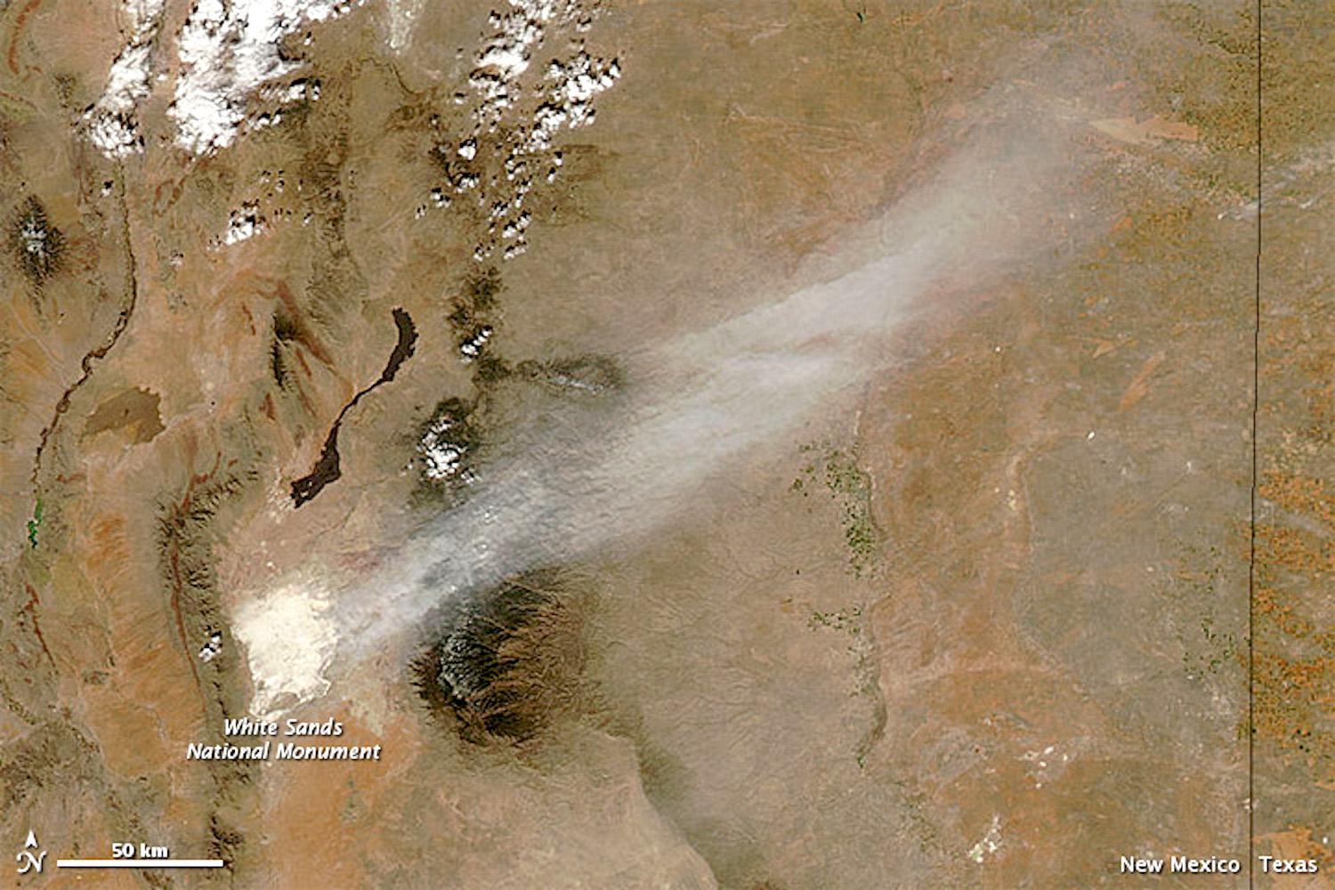
“White Sands is considered to be a dust hot spot,” said David Bustos, the resource program manager at White Sands National Park. High-speed wind events like this one in 2012 captured (before White Sands was redesignated a national park) by NASA aerial imagery blow fine dust and sand particles across state lines/NASA
Drought Is Reshaping The National Park Landscape In Unprecedented Ways
Blowing sand, relentless bark beetles and invasive grasses are just some of the consequences of continued hot, dry weather.
By Jonathan Horwitz
Editor's note: This is the third article in a series of stories National Parks Traveler is producing on how the long-running drought in the Southwest is impacting units of the National Park System.
Hot, dry weather caused by climate change is reshaping the landscape in many Western national parks, and bringing with it an uneasiness over how plants, animals and visitors will be impacted.
It has become clear that Alaska’s glaciers are melting faster than most climate change experts had anticipated, but it’s not well known that the sand dunes at White Sands National Park in New Mexico are experiencing their own kind of decline also caused by the same hot, dry temperatures.
They are, experts say, literally being blown away by severe drought conditions linked to climate change.
“The dunes are sort of like melting glaciers,” David Bustos, the park’s resource program manager, told the Traveler. “We see them warming up and breaking down quickly.”
And while Alaska’s glaciers are spilling tons of water into the area’s bays, the dunes at White Sands are blowing fine gypsum particles as far as the Texas Panhandle because warmer temperatures and dryness are destabilizing the sand masses and high-speed wind events are moving particles across state lines, Bustos said.
“Wind blows the dust up all the time,” Bustos said. “White Sands is considered to be a dust hot spot.”
The gypsum sand historically is so moist from shallow groundwater that he can cup it in his hands like a snowball, Bustos said. During drought, he can feel the difference.
“It’s sort of more airy. Usually it’s very heavy, but as it dries out it becomes very, very light. There’s no ability to walk on it. You start sinking in. There’s no solid surface,” he added.
The dunes, which can stand up to 60 feet tall, are bound by soil moisture from groundwater that rests as shallow as six to 12 inches below the surface, Bustos said. During most winters, cold temperatures freeze the water table and create what Bustos calls a stable “resting period” when the sand is relatively very stable.
Recently, however, warming winter temperatures and year-round aridity are causing more erosion and movement than normal.
“If the dunes don’t freeze or get soil moisture, they’ll get dried out,” Bustos said. “We’re going to see large movements of the sand here year-round.”
According to the NPS, the dunes formed less than 10,000 years ago after another warm and dry climate period evaporated multiple lake beds in the Chihuahuan Desert and left behind layers of gypsum and other dissolved minerals that had been in the area for millions of years.
Today, the dunes are about 98 percent gypsum, a soluble mineral that crystallizes during natural cycles of flooding and evaporation. Wind and water break down the crystals into progressively smaller particles until they are fine grains of white sand and eventually dust.
Although there are no known negative health effects from breathing in the suspended particles, Bustos said the shifting sands can still have consequences for humans.
In 2008, during a previous drought, high wind speeds caused some dunes to sweep across the park’s main road, closing it off for more than two weeks.
Bustos expects this to happen more frequently due to drought.
“During a drought season, there is more dune movement, and it starts to become almost impossible at times to open up and maintain roads,” he said.
He also worries about hiker safety as winds blow trail markers out of place and cover footprints.
“During drought, I believe we see more incidences of visitors being lost in the park,” Bustos said.
Although the park’s 275-square-mile gypsum dunefield is the largest in the world, a history lesson from across the Mexican border shows it’s not invincible to human-caused climate change and development.
Dunas de Yeso (Gypsum Dunes) in Coahuila, Mexico, had many dunes that rivaled the size of those in New Mexico. In recent decades, the dunefield has suffered from reduced spring discharge and a decrease in surface water. Scientists are unsure whether this is an effect of climate change or industrial agriculture or if both contribute to the problem, but many of its large dunes have disappeared.
In June, the NPS completed a climate change scenario planning guide for White Sands, preparing for the possibility that extended drought further destabilizes the dunes, potentially shifting the sands across park boundaries and jeopardizing the habitats of native plants and wildlife.
“Scenario planning gives us an idea of what direction we're going and how to plan for that as we start to understand what's happening,” Bustos said.
Next door in Arizona, it’s a 60-foot-tall plant that’s under threat from drought.
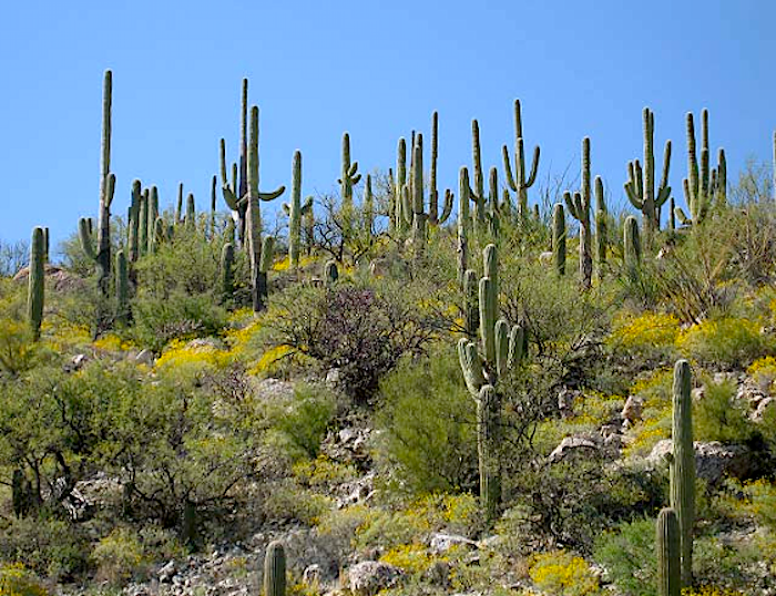
A mature saguaro can grow that tall and weigh as much as 4,800 pounds. But the cactus’s impressive figure and thorny exterior hide its delicacy.

Winter minimum temperatures have risen 15 to 20 degrees Fahrenheit within the lifespan of most mature saguaros, which can live for 150 or more years./NPS, Alice Wondrak Biel
Rising winter temperatures and drier soils have diminished the number of young saguaros reaching reproductive age since the mid-1990s, according to the NPS.
“Saguaros just haven’t had the right conditions in the last 25 years, and you could say that maybe climate change has played a role in that,” NPS Ecologist Andy Hubbard told the Traveler. “The Sonoran Desert has mostly been in drought conditions since around 2000.”
Hubbard said that even mature cactuses are exhibiting strange, unexplained reproductive behaviors, such as flowering in the fall instead of the spring or hardly flowering at all some years.
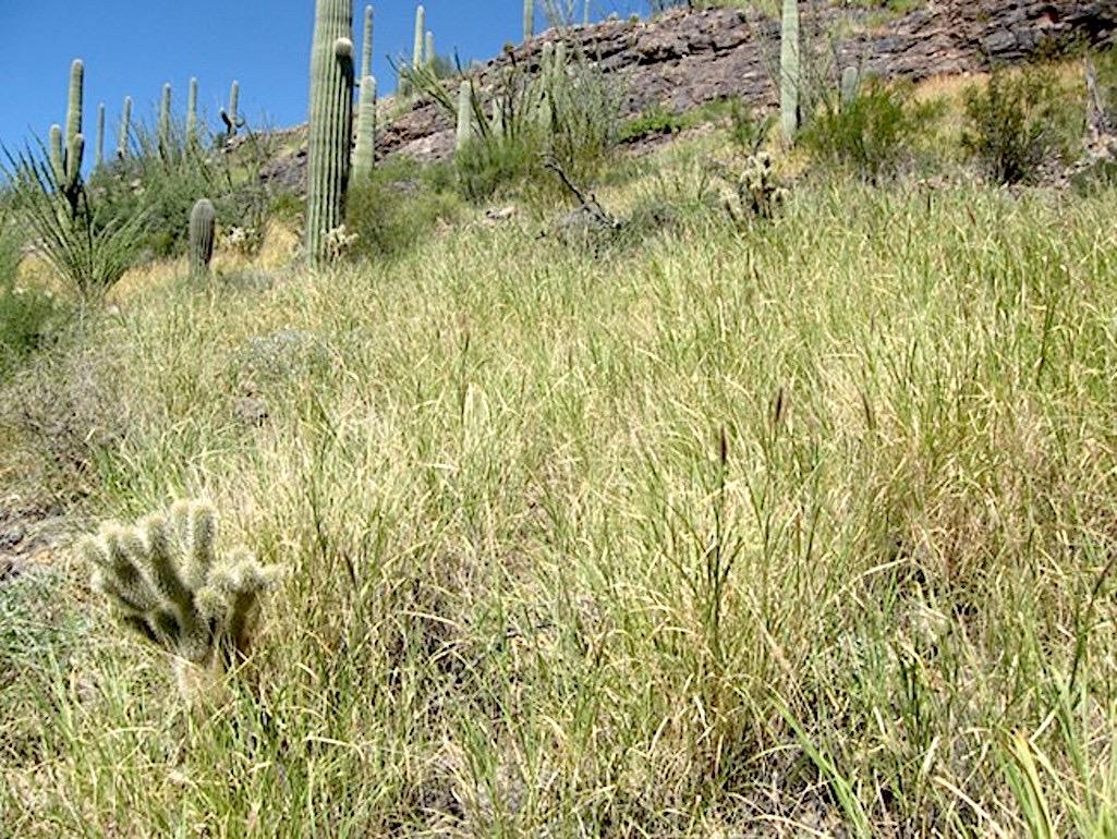
Meanwhile, warmer temperatures create optimal conditions for invasive grasses, particularly buffelgrass, a perennial from Africa that is out-competing Sonoran Desert natives. Buffelgrass can fuel severe fires that threaten the saguaro and other indigenous species. The U.S. Geological Survey says it has the potential to “transform the Sonoran Desert ecosystem from a diverse assemblage of plants to a grassland monoculture.”
Hubbard said that the human-caused 2019 Woodbury Fire burned through swathes of red brome, another invasive grass, in and around Tonto National Monument, also found in Arizona, and killed saguaro cactus and other native species “in huge numbers.”
“The surrounding area looks like a moonscape,” he said.

Buffelgrass was imported to Arizona in the 1980s for erosion control. Today, it is out-competing native plants and can fuel severe fires in Saguaro National Park./NPS
Perhaps the strangest drought-related phenomenon in the national parks system is happening in California where bark beetles are attacking Giant Sequoia trees.
The tiny insects have killed nearly three dozen mature Sequoias since 2014, something that had never been recorded prior to California’s last multiyear drought.
Taxonomists still disagree about which beetle species to blame. But one reason researchers are paying so much attention is drought. Beetles fare better in warmer, drier climates while Sequoia trees fare worse.
“If those beetles are responding to a warming climate while the sequoia is getting more stressed, they could become a big issue in the future,” said USGS Research Ecologist Nate Stephenson.
As the Traveler reported this spring, beetles are among the litany of threats confronting sequoia trees like never before in their ancient lifespans. And ongoing research estimates suggest that wildfires have burned more acres of sequoia ranges since 2015 than in the previous century combined, according to multiple park ecologists.
“I’ve heard an estimate that two-thirds of all grove area has burned in wildfires (since 2015),” said Stephenson. “That’s like a fifty-fold uptick over the previous century. It’s a huge uptick.”

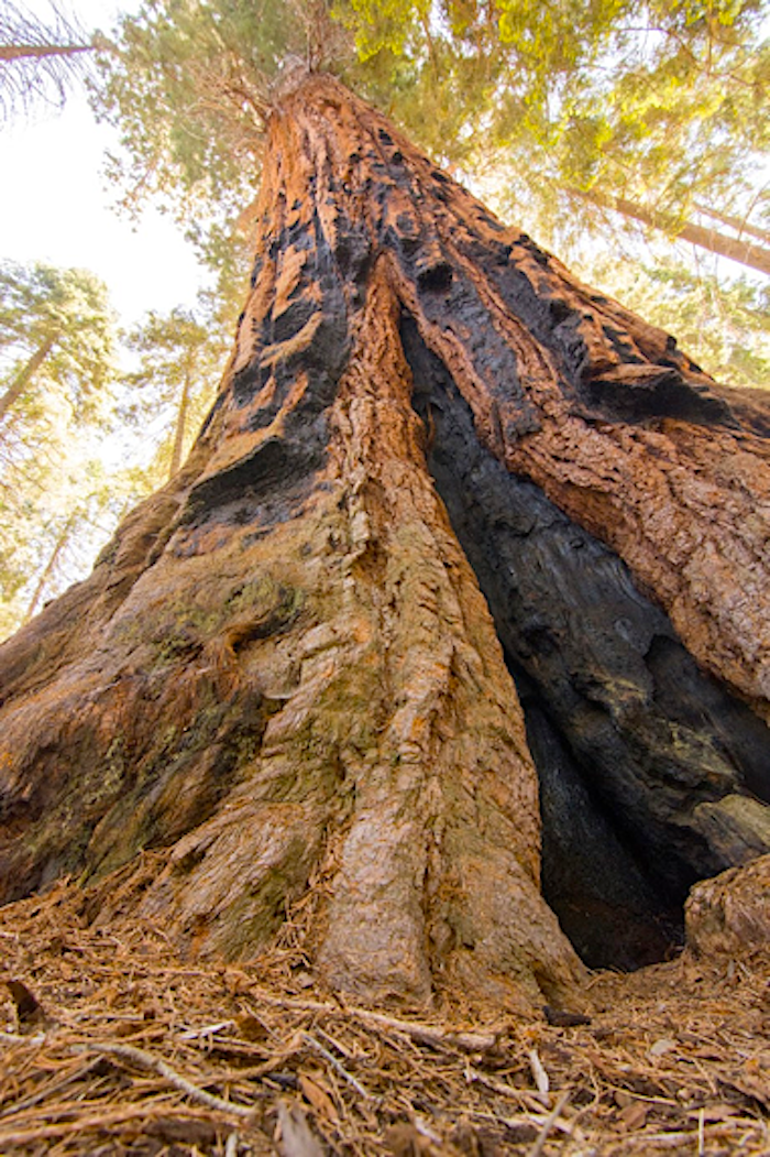
Many Giant Sequoias are scarred by fire, which opens their pine cones to allow reproduction. Recent high-severity fires have burned hotter than normal and caused the trees to perish / Jonathan Horwitz file
While sequoia trees are well adapted to fire and require fire to reproduce, high severity fires linked to climate change burn too hot for the trees to handle.
“The fire behavior that we are starting to see in Sequoia groves is not the kind of fire that these trees have evolved with,” said Christy Brigham, the park’s chief of resource management and science.
The 2020 Castle Fire killed between 10 and 15 percent of all mature Sequoias, and Brigham said another burn like that is not out of the realm of possibility.
“Something like 30 percent of the grove area under our quick survey pass is still susceptible to high severity fire,” she said. “So, I think we can’t say that this threat to sequoias is gone. It is very much still a real threat that could lead to another large impact fire.”
The most popular groves — the Giant Forest and Grant Grove in Sequoia and Kings Canyon national parks — are better adapted to fire as the beneficiaries of prescribed burns dating back to the 1960s, she said.
However, many other groves are in what she describes as “overly-dense” forests after a century of fire suppression.
Plus, she said, the drought from 2012-2016 made matters worse.
“That drought killed a lot of trees in the southern Sierra, creating fuels so high in and around Sequoia groves that when a fire gets going in those groves it gets into the canopy 100 to 200 feet off the ground, incinerates all the needles, burns up all the cones, kills a large proportion of the Sequoias that are present and, we think, is preventing regeneration and reestablishment (of young trees) in some of these high severity burn areas.”
Despite all that, sequoias have handled drought better than some other tree species in the Sierra Nevada, according to scientists.
Stephenson’s research shows that during California’s drought between 2014 and 2016:
● Roughly 70 percent of large sugar pines between 5,000 and 6,000 feet in elevation died.
● About 50 percent of large ponderosa pines at the same elevations died.
● Overall tree mortality in that elevation range was slightly greater than 20 percent.
Elsewhere in the National Park System, drought — and its related impacts — continues to take a toll:
● After months of no rain, the Dome Fire burned 40,000 acres of Joshua trees in Mojave National Preserve last August. “The fire was climate-change influenced,” said Debra Hughson, the preserve’s science advisor.
● The woodlands in Bandelier National Monument in New Mexico never recovered from a multiyear drought in 2002-03 that killed most of the park’s pinyon pines. Rather, warmer temperatures and forest fires resulted in the “widespread conversion” of pinyon-juniper and ponderosa forest to oak-locust shrublands, according to an NPS report.
● The die-off of millions of acres of pinyon-juniper forests continues today in the Four Corners region, including in Canyonlands National Park in Utah. NPS Ecologist Dusty Perkins calls the trend “alarming.” “The last couple of years, we’ve seen desert plant species dying that should be pretty adapted to desert systems,” Perkins said.
● Since 2000, drought has reduced flows along the Colorado River by about 20 percent, and the USGS expects stream flows to decrease by two to 15 percent for every one degree Celsius increase in temperature. Today, increasing demand for water by human populations is being met with historically low rainfall and river flows induced by climate change. The NPS says that the stream flows of virtually all tributaries that feed into the Colorado River have been altered by water development projects, resulting in diminished peak flows, channel narrowing and simplification, and loss of riparian biological diversity. “We’re hoping to try and keep a river, not a beautiful irrigation ditch,” Perkins said.
● Organ Pipe Cactus National Monument in southern Arizona is home to several critical ecosystems reliant upon depleting groundwater. The water is not being replenished at sustainable rates due to far below average rainfall. According to park management, several ecosystems that draw water from underground springs are seriously threatened along with the species that live there.
● Nearby San Bernardino National Wildlife Refuge on the US-Mexico border groundwater extracted to assist construction on President Trump’s border wall threatened endangered species, according to internal emails from the U.S. Fish and Wildlife Service reviewed by azcentral.com. “Groundwater extraction and groundwater law is something that we’re pretty concerned about,” NPS Research Ecologist Hubbard said.

Add comment