
Layers in time, John Day Fossil Beds National Monument / Rebecca Latson
My home in the Pacific Northwest is from 2 hours to a full day’s drive of several national parks, national monuments, and national recreation areas. Because of the nearness of so many public lands, my 2020 goal is to travel to and photograph at least one or two units I’ve never visited within the National Park System. So, this past March, I packed the car and headed to John Day Fossil Beds National Monument in eastern Oregon, where I spent 3 days exploring and photographing the area. This national monument is an absolute treasure trove of plant and mammal fossils ranging from 7 million to 44 million years in age. I can barely wrap my head around 20 years, much less millions of years. John Day Fossil Beds is chock full of amazing geological features and gorgeous scenery perfect for your camera, with plenty of learning opportunities for your brain.
Planning For The Visit

Overview map of John Day Fossil Beds National Monument / NPS
To visit John Day Fossil Beds, you need to know a few things to help with your travel planning. The first thing you should know is that there are three units to this national monument, and each unit is about an hour’s drive away from the other on up-and-down, twisty-turny secondary roads (i.e. two-laners). It sort of feels like you are driving a rollercoaster track. So, while you could ostensibly visit all three units in a single day, I do not recommend it. You’d spend most of your day driving and you wouldn’t get a true feel for any of the units. And, speaking of curvy roads, this part of eastern Oregon is rural, with numerous large and small cattle ranches in between units. Open range means you should watch out for any cow standing in the middle of the road around those blind corners.
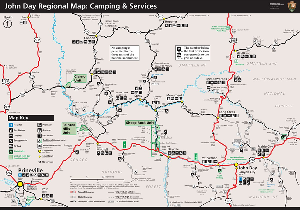
Camping and services map around John Day Fossil Beds National Monument / NPS
Gas stations are few and far between, so make sure you’ve got a full tank from the towns of Prineville or John Day to make it out to and back from the three units. It goes without saying, you should also have plenty of water and food with you.
In between each unit, the towns are very small, with populations between 100 – 700, give or take. While there may be limited places to hang your backpack in these towns, you’ll find more consistent, modern accommodations in Madras (pop. over 6,800) or Prineville (pop. over 9,000) west of the monument, or John Day (pop. over 1,000) east of the monument. Click here for more lodging information. Camping is not allowed in any of the 3 units, but there are campsites on USFS and BLM lands outside of the monument boundaries. For more camping information, click on this link.
Each unit has a few well-maintained, very short hiking trails that are easy enough for all ages. Some trails have steps to negotiate, and a couple trails are slightly steep, but nothing that can’t be tackled by slow going and frequent rest stops. Most of the trails are between .25- and 1.5-miles round trip. The longest is the Blue Basin Overlook Trail in the Sheep Rock Unit, with a length of 3.25-miles round trip.
So, what can you do and see in 3 days? Plenty. Let’s follow the units, from west to east.
The Clarno Unit

The Clarno Unit, John Day Fossil Beds National Monument / Rebecca Latson
Looking toward the Palisades, Clarno Unit, John Day Fossil Beds National Monument / Rebecca Latson
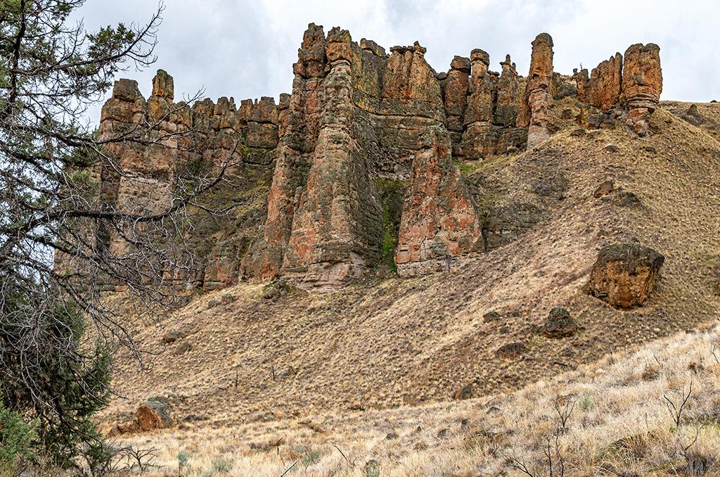
The Clarno Unit is the northernmost unit within this national monument. There are restrooms with non-flush toilets and hand sanitizer, and a picnic area near the parking lot. The most striking feature within this unit are the tall Palisades, looking like ancient battlements on the hillside. The Palisades are remains of lahars (volcanic mud and ash flows) that flowed down the flanks of an ancient volcano, mowing down any plant or animal in the way. There are three very short trails taking you to different viewing angles of these ancient lahars. See if you can spot any fossil plants embedded in the rocks. I didn’t, but my fossil-finding powers are a little on the rusty side. If you do see any fossils, just take photos of them and please leave them alone. It is illegal to take fossils from any of the 3 units of this national monument.

Walking along the Geologic Time Trail, Clarno Unit, John Day Fossil Beds National Monument / Rebecca Latson

44 million years ago along the Geologic Time Trail, Clarno Unit, John Day Fossil Beds National Monument / Rebecca Latson

A view of the Palisades from the picnic area, Clarno Unit, John Day Fossil Beds National Monument / Rebecca Latson
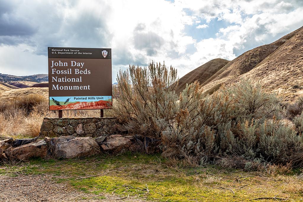
The Painted Hills Unit
The Painted Hills Unit, John Day Fossil Beds National Monument / Rebecca Latson

The Painted Hills Overlook, Painted Hills Unit, John Day Fossil Beds National Monument / Rebecca Latson
Here, one can spend an entire day from dawn to dusk, photographing and hiking these “painted” hills. Different weather and lighting conditions dramatically change the appearance of these stunning striped hills. Sunny days cause the soils to pop with saturated color. On overcast days, the undulating folds of these hills look like shadowy, rich, maroon-and-olive-striped velvet.

Late afternoon in the Painted Hills Unit, John Day Fossil Beds National Monument / Rebecca Latson
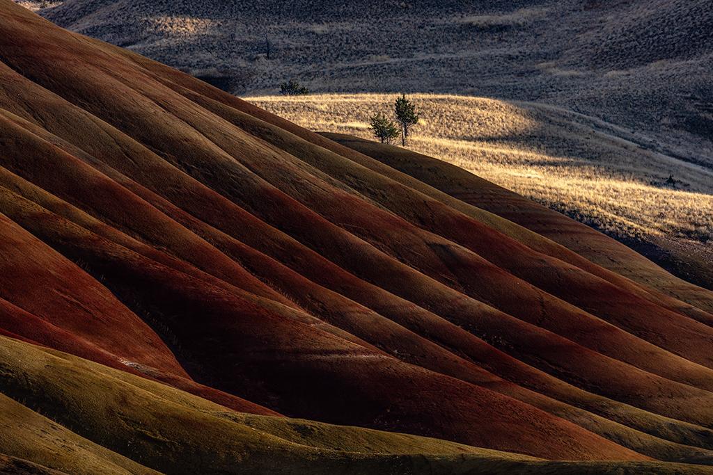
Velvet folds of undulating colors, Painted Hills Unit, John Day Fossil Beds National Monument / Rebecca Latson
The red/maroon – yellow/olive green layers are examples of ancient climate change. During wetter periods, the iron minerals oxidized and turned the soil red, while drier periods are represented by non-oxidized yellow-ish colors. These wet and dry periods also accommodated different ecosystems. Near the Red Hill Trail, you’ll see a small white hill, indicating the remains of a 39-million-year-old superheated ash and gas flow covering the land and marking the boundary between the older Clarno Formation and the younger John Day Formation.

The white hill, Painted Hills Unit, John Day Fossil Beds National Monument / Rebecca Latson

What is that white hill? Painted Hills Unit, John Day Fossil Beds National Monument / Rebecca Latson
The road through the Painted Hills Unit is easily-navigable gravel. There are no restrooms except at the entrance, where there is also a small information center with trail, camping & available services, and regional maps of the national monument. There are 5 short trails within this unit, ranging from .25 – 1.6 miles round-trip. The longest trail is the Carroll Rim Trail, which I highly recommend for a stunning panoramic view of this unit.
As you walk along the trails in between these painted hills, take a close look at your surroundings. Notice the texture and patterning of the colorful soils. Listen to the birdsong. During my visit, I heard the honking of geese as they flew low between the hills. Of course, you’ll want to get plenty of wide-angle shots of the landscape, but use your telephoto lens or telephoto setting, as well. Zoom in to capture the light and shadow rippling over the hills. Isolate one or two of the sparse trees growing atop those hills. Look closely at the textures of the crumbly soils. Capture some "leading line" images of the trail you are on. Leading lines move the viewer's eye from one part of the photo to the other, allowing the eye to linger on the image and take in more detail. Remember, panoramic shots present the Big Picture, but telephoto images flesh out the story of Painted Hills creation.

Crumbly yellow soil, Painted Hills Unit, John Day Fossil Beds National Monument / Rebecca Latson

Crumbly red soil, Painted Hills Unit, John Day Fossil Beds National Monument / Rebecca Latson

Red Scar Knoll, Painted Hills Unit, John Day Fossil Beds National Monument / Rebecca Latson
Sheep Rock Unit
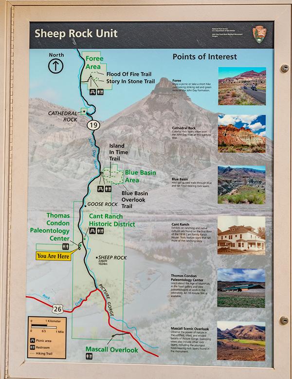
Sheep Rock Unit map, John Day Fossil Beds National Monument / Rebecca Latson
This is the largest unit of the three, with many available photo ops of the beautiful and colorful geology and scenery. Stop at any of the pullouts to marvel at the columnar basalts of Picture Gorge.

Picture Gorge basalts, Sheep Rock Unit, John Day Fossil Beds National Monument / Rebecca Latson

Picture Gorge basalts description, Sheep Rock Unit, John Day Fossil Beds National Monument / Rebecca Latson
You’ll also capture beautiful images of Sheep Rock itself, towering over the John Day River.

Sheep Rock and the John Day River, Sheep Rock Unit, John Day Fossil Beds National Monument / Rebecca Latson
Sheep Rock Unit is home to the Thomas Condon Paleontology Center, housing display cases filled with fossil specimens of plants and mammals, and walls decorated with huge, colorful murals depicting ancient landscapes millions of years ago. There’s also a working lab with a large picture window through which you can watch a technician painstakingly clear away rock matrix around a fossil nut, leaf, or bone.

The Thomas Condon Paleontology Center, Sheep Rock Unit, John Day Fossil Beds National Monument / Rebecca Latson

Thomas Condon Paleontology Center Lobby, Sheep Rock Unit, John Day Fossil Beds National Monument / Rebecca Latson

Fossils on display at the Thomas Condon Paleontology Center, Sheep Rock Unit, John Day Fossil Beds National Monument / Rebecca Latson

The window into the lab at the Thomas Condon Paleontology Center, Sheep Rock Unit, John Day Fossil Beds National Monument / Rebecca Latson
After your visit to the paleontology center, why not stretch your legs on nearby trails such as the Thomas Condon Overlook, the Island in Time trail at Blue Basin, or drive five miles further north to the Foree area for a couple more short hikes with gorgeous vistas. Don’t let bad weather stop you from marveling at the colorful rock formations. Rain actually saturates those shades of pinks, greens and yellows.

A rainy-day view along the Story in Stone Trail in the Foree Area, Sheep Rock Unit, John Day Fossil Beds National Monument / Rebecca Latson

The goose on top of the green claystone hill in the Foree Area, Sheep Rock Unit, John Day Fossil Beds National Monument / Rebecca Latson

The view at the end of the Flood of Fire Trail in the Foree Area, Sheep Rock Unit, John Day Fossil Beds National Monument / Rebecca Latson
If you feel like learning a little history about the settlers who lived there, check out the James Cant Ranch House, renovated to accommodate park headquarters and a museum.
One more stop before you end your day should be the Mascall Overlook, just off Hwy 26 heading east toward the town of John Day. From this vantage point, you’ll see the Upper John Day Valley, the Strawberry Mountain Range, Picture Gorge, and the Mascall and Rattlesnake formations.

A wide-angle view of the Mascall Formation, Sheep Rock Unit, John Day Fossil Beds National Monument / Rebecca Latson

Picture Gorge and John Day Valley seen from the Mascall Overlook, Sheep Rock Unit, John Day Fossil Beds National Monument / Rebecca Latson
Yes, three days is plenty of time to see and explore the three units in John Day Fossil Beds National Monument. After a visit there, you’ll return home with beautiful photos and a better understanding of the life and ecosystems that existed millions of years ago in what is now eastern Oregon.
The view from the Carroll Rim Trail overlook, Painted Hills Unit, John Day Fossil Beds National Monument / Rebecca Latson


Comments
Thank you for your thorough overview. I really enjoyed learning about these parks.
A superb write-up (and excellent photos, as usual) for one of the lesser-visited parks in the Pacific Northwest. During the warmer months, the Clarno Unit is a superb place to be serenaded by the sounds of canyon wrens. Picture Gorge is noted for its Native American rock art. Sadly many panels have been vandalized (and no parking is allowed in the Gorge), but there is a pull-out at the east entrance and some well-preserved panels still exist (if you know where to look); there are also some pictographs at the Clarno Unit as well.
What a wonderful write up. We were there some months ago and did not receive much of a welcome at the Visitor's Center. Your write up and photgraphs make us want to go back before we finish our quest for all units i nthe system and we are at 382 out of 419.
Thank you so much for sharing this. My first trip is next week. Life-long Oregonian. My dad was from Arlington and my Grandparents met in Shaniko.
Thank u for this beautiful information.
Just got back from a March trip, the painted hills were spectacular!
We appreciate the advice about going with a full tank of gas. We didn't have a whole lot to spare when we finally reached a station!