
Editor's note: Flint Shoop and his wife, Kellie Chidester, recently had the chance to spend a day at Black Canyon of the Gunnison National Park in Colorado. They chose the quieter side of the park, the North Rim, and after 24 hours left wishing they had more time to enjoy the park. Flint pulled the words together, while Kellie focused her camera on the landscape.
Anyone who has studied a national park long enough realizes there is no way to fully appreciate what they have to offer in 24 hours. Changing light and changing seasons can make the most familiar features new again. In our recent June visit, my wife, Kellie, and I attempted to absorb, in a 24-hour visit, the less-visited vertical landscape of the North Rim of the Black Canyon of the Gunnison National Park in western Colorado.
Journey to the North Rim
After exploring western Colorado for two weeks, our itinerary led us to the Black Canyon. From the beginning, our plan focused on the less-used North Rim of the canyon because we’re not fans of crowds. In the morning, we drove from Ouray to Montrose, Colorado, to restock our camping supplies, and then on north to Delta before making our turn east toward Crawford, the gateway to the North Rim. Highway 92 is a heavily used route, especially by those involved with the vigorous fruit industry of the area. Once we reached Crawford and passed Crawford State Park, the many turns on the local roads to get to the park entrance took some focus, even if the signage for the park is sufficient.
The views of the surrounding valley to the north and mountains east of Crawford are vistas in their own right, and the eye-catching monolith, Needle Rock, west of Crawford was hard to leave behind, but we were bent on reaching our destination. As park visitors come to the end of the pavement, the park’s boundary begins. Unlike the more easily reached South Rim with its paved roads, the North Rim roads are dirt. Much to our relief, the road proved smooth and pleasantly dust-free from repeated coatings of magnesium chloride, also used as a de-icing agent, and made for a surprisingly comfortable trip into the park..
Compared to the South Rim with its visitor and Park Service infrastructure, the only facility on the North Rim is a small ranger station with attached living quarters. Within the station expect to find only essential park information, with no park related souvenirs or supplies for sale.
When we arrived, I showed our America the Beautiful annual pass to the park employee and he nodded in approval. On the North Rim, day use seems to be based on the honor system; thankfully, when we later paid our camping fees, the fee tube was full. At the ranger’s station, several families were unloading for a three- to six-mile hike on the North Vista Trail. On the station’s porch, inner canyon hikers had registered their hiking times and routes as required by the park. The canyon’s inner reaches are for experienced hikers and climbers. Even so, just two years ago a hiker fell to his death within the park.
Visitors cannot help but be awed by how the Gunnison River has carved such a gash through the tremendous rock features of the canyon. According to the Black Canyon National Park guide, during the 2 million years of the canyon cutting, the undammed river “used to slam through this gorge in flood stage at 12,000 cubic feet per second with 2.75-million-horsepower force dramatically scouring the riverbed and eroding the canyon walls.” And even today the river strikingly drops “480 feet in one two-mile stretch.” As we zoomed to the river at the canyon’s bottom, even the low flow of a dry year showed the water’s tremendous speed and force.

Wobbly Knees And Tight Stomachs
After our stop at the ranger station, it was nearing 10 a.m., so we drove the short distance to the North Rim campground. The ranger said we would have our pick of available spots. We picked a level site, and like children at an amusement park, we wanted only one thing – to see the up-to-2,700-foot deep canyon. From the campground, Chasm View Nature Trail is a walk through sagebrush and the dramatic, twisted Utah juniper trees and pinyon pines. According to the park’s Chasm View trail guide, Beyond the Brink of Time, “some of the oldest groves of pinyon pines in the United States are found at Black Canyon. Some of the trees have been growing here for nearly eight centuries.”
We scrambled down the dirt-and-rock trail eager to catch our first glimpse. Heights have never bothered us in our travels, but as we walked toward the fence at the first Chasm View, something began to happen to our bodies. The cooler air rising from the river far below greeted us at about the same time as the churning sound of the river. As our hands reached out to the fence railing and we peered over the edge to the bottom, our stomachs tightened and our knees grew weak. Even as we leaned forward, our hands’ grip on the rail tightened, and we had to believe that most visitors couldn’t help but feel a sinking sensation from the sheer height or depth of the canyon whose vertical walls drop straight down toward the river.

Within the canyon there are so many features, shapes, and colors that the human eye can be overwhelmed trying to take it all in. During the course of our 24 hours within the park, it became clear that there is no way to fully appreciate the many moods and personalities of the canyon in a few hours. The cycle of sunlight changes the canyon’s character almost hourly, and there is no doubt that the seasons can have the same effect.
We wanted to experience as much of the canyon’s brilliance as possible, especially with our cameras, and it was clear we had our work cut out for us. Within the Chasm View loop, there are two overlooks equally terrifying and breathtaking. At many points along the trail near the canyon’s edge the Park Service has stacked dead junipers and pines to help visitors avoid a slip and fall over the canyon’s edge, and yet, it is likely too many visitors walk out to points on the canyon on rocks or slopes where one misstep will end in disaster.
We spent a short time at the second viewpoint, watching the South Rim visitors at the matching Chasm View on that side. We then made our way back up the trail to our camp spot, where the trail splits off into fingers like a river delta with no clearly defined main trail. We decided to skip camp setup and threw a couple of camp chairs into our site. We knew we wanted to see as much of the park and the North Rim as possible in the daylight, so we jumped in our vehicle and set off for the five other viewpoints easily accessible via a branch of the North Rim road.
On To North Rim Viewpoints
Driving to the North Rim viewpoints, we began to realize that the dirt road, at times, runs perilously close to the canyon edge, and although the road is well-maintained, drivers should, both for safety and politeness, drive at slower speeds. At our first stop, there is a short walk to the Narrows View. This viewpoint features the narrowest width of the canyon walls where the river winds through only a 40-foot width. As with all viewpoints, weak knees and tight stomachs dominate the body’s reaction while grasping the rails to peek over the edge. The constant roar of the Gunnison River so far below creates a hypnotic effect for those pausing long enough to soak in their surroundings. We spent an average of 30 minutes at each viewpoint to try and take in not only the tremendous canyon’s unique character, but also to appreciate the plant life of the rim and understand the changing rock types.
On the canyon’s edge, plant life is scattered in between the cactus, yucca, and varied rocks. Flowers making their annual appearances range from the unexpectedly delicate sego-mariposa lily to clusters of scarlet gilia and scarlet paintbrush to the silvery lupine and whiplash daisy and small yellow stonecrops that attract black and white Weidemeyer’s Admiral butterflies. Skirting among the flowers, the bright blue bellied sagebrush lizards and their collared counterparts create unexpected movement. Crystalline rocks abound, shimmering like precious metal thanks to their mica layered sheets.

There are six North Rim viewpoints accessible by vehicle compared to the 12 or so viewpoints on the South Rim, and as we looked south across the canyon we could see larger groups of park visitors. On the North Rim, the one to two visitors made for a more intimate and peaceful experience. The churn of the river and bountiful bird life filled the air as Violet-green Swallows dove in and around us to scoop up insects. Often they passed so close by we could hear the vibrating “whooooosh” of their wings cutting through the canyon expanse. Great horned owls also are residents, as are vultures that regularly soar above the canyon looking for a meal.
We soaked in the subtle and striking differences at the Balanced Rock, Big Island, Island Peak, and Kneeling Camel viewpoints. Although the namesake for each spot is worth identifying and viewing, we found it was often the smaller or more distant details that caught our attention – the layering of rock or the growth of pines in places seemingly impossible to reach. We mulled rising questions about whether we would ever attempt to hike down a South Rim trail to the river, or what it would be like to try to hike along the river far below. All of this, engrossed our imagination, leaving a lasting imprint on our memories.
Every possible canyon feature is present here, from balancing rocks, monolithic spires, long stretches of eroded rock resembling backbones, evenly cracked rock groups that appear as though constructed by masons, splashes of bright colors added by lichens and mosses, rock jumbles bringing to life imagined thunderbirds, plateaus of isolated pine forests, solitary pines growing strangely out of cliffside rocks, and separate descending canyons that, in their own right, would be a sight to behold in any other setting.

Throughout our travels, we appreciate and examine the intricate craftsmanship and often dangerous work completed by those hearty souls during early 1930s for the Civilian Conservation Corps or through the Works Progress Administration. Nearly 90 years later, the stonework seems as new as ever, and roads hewn decades before reflect an era of craftsmanship not seen today. On the National Park Service website there is little information about the park’s history, and a viewer might believe Black Canyon of the Gunnison was created in 1999, though even Wikipedia informs us a national monument was first formed here in the early 1930s. Maybe the visitor’s center on the South Rim does a better job of telling the park’s history.
It’s difficult to know the entire 14 miles of the park’s river course, as the large northwest section, which accounts for more than half of the park, has no roads or marked trails. On the road back to the campground, “slow speed” and “dangerous curve” warning signs in bright yellow announce that going more than 20 mph might send your vehicle over the edge, which has no guardrails.
Return To Camp - Chasm View Revisited
Back at the campground, we surveyed the facilities. We had spent nine nights in national forest campgrounds, all well-maintained with raked campsites and clean vault toilets. The North Rim campground is much the same, but differences in maintenance styles between the federal agencies is apparent. At the campground, there are 13 first-come, first-served somewhat tightly spaced campsites. Travelers with larger recreation vehicles may find only a few sites fit for their vehicles. Sites have ready access to bear boxes and all have plentiful shade from the pines and junipers. After our survey, it was clear for at least that night, most of the sites were in use. We decided to cook an early dinner on our butane camp stove as, by this point in our trip, nearly all of Colorado was in a stage two fire ban forbidding open fires.

At 5 p.m., we’d made our plan to soak up the changing character of the canyon until sunset at the varied Chasm Views. These overhangs offer inspiring views of nearly the entire Painted Wall section of the canyon. The sun began its descent over the highest point of the park at 8,563 feet. This rise is just to the west of the canyon where the walls run north to west and then south to west on a major bend in the river. Over the next two hours, our cameras captured the ever-changing color and highlights of features as shadows began their slow climb up the southern and west facing walls, plunging large portions of the canyon into darkness for more than 12 hours a day, with some points only receiving sunlight for less than an hour. The shadows themselves have life, and we began to imagine the shapes of mountain lions chasing bighorn sheep or peregrine falcons soaring and searching for prey. Finally, the afternoon's creeping shadows formed a spooky horned creature that seemed to rise from the canyon bottom to announce the arrival of night.
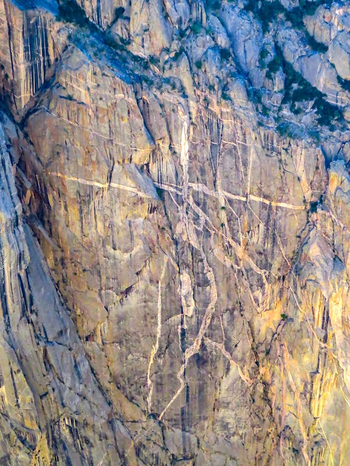
From our experience, there is NOT one canyon. Each passing hour and sometimes minute brings to life a new canyon, unseen a moment before with its own unique lighted detail or shadowed face. Black Canyon becomes a visceral experience for those willing to spend time absorbing it. Colors, light, and shape make the eyes feel as though they’ve gone to a feast and after time are ready to explode from absorbing too much. The painted walls of the canyon vary from the streaks of black tightly spaced vertical lines of the Desert Varnish created by iron and manganese oxide concentrated by bacteria and regular water, to the contrasting light-colored pink pegmatite rambling lines running every direction on the opposing walls of a giant 2,000-foot monolith. Camera exposure adjustments can heighten the color depths and bring out interpreted shapes and scenes created by the artistic puzzling lines.
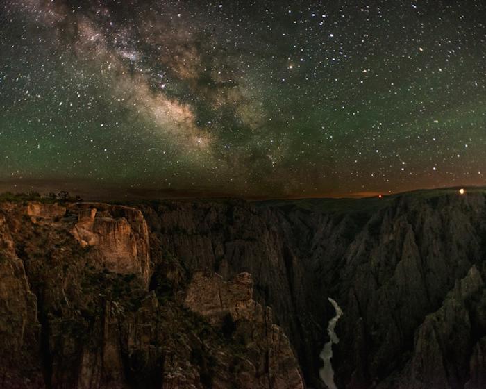
Back in camp with twilight setting in, mountain bluebirds and white-throated swifts and other birds flitted into trees for the night, serenading us with song. At Kellie’s urging, we walked back down to the edge for one last look. This time we sat near the edge on some rocks without a safety rail, but still back from the very edge so our stomachs wouldn’t cramp. We watched as the last light of the day lit up the canyon near Sunset View on the west-facing walls farther down the canyon. The moonless night sky filled with a blanket of stars and cloudy Milky Way. We had just missed the Black Canyon Astronomy Festival the previous week, but it didn’t matter because on clear nights the sky overwhelms because the canyon area is designated an International Dark Sky Park.
In the morning, there was a slight chill during breakfast, and again we walked down to the edge for one last look. To no surprise, it was a different canyon once again, just as it has been for millions of mornings before. We did not want to leave, but our itinerary held more national park experiences and so we reluctantly said farewell.
No one should miss an opportunity to visit the Black Canyon of the Gunnison National Park, whether on a more solitary North Rim visit or the more accessible South Rim. Hopefully, they can stay for more than a few hours.
Stories about:
Story Categories:
A copy of National Parks Traveler's financial statements may be obtained by sending a stamped, self-addressed envelope to: National Parks Traveler, P.O. Box 980452, Park City, Utah 84098. National Parks Traveler was formed in the state of Utah for the purpose of informing and educating about national parks and protected areas.
Residents of the following states may obtain a copy of our financial and additional information as stated below:
- Florida: A COPY OF THE OFFICIAL REGISTRATION AND FINANCIAL INFORMATION FOR NATIONAL PARKS TRAVELER, (REGISTRATION NO. CH 51659), MAY BE OBTAINED FROM THE DIVISION OF CONSUMER SERVICES BY CALLING 800-435-7352 OR VISITING THEIR WEBSITE. REGISTRATION DOES NOT IMPLY ENDORSEMENT, APPROVAL, OR RECOMMENDATION BY THE STATE.
- Georgia: A full and fair description of the programs and financial statement summary of National Parks Traveler is available upon request at the office and phone number indicated above.
- Maryland: Documents and information submitted under the Maryland Solicitations Act are also available, for the cost of postage and copies, from the Secretary of State, State House, Annapolis, MD 21401 (410-974-5534).
- North Carolina: Financial information about this organization and a copy of its license are available from the State Solicitation Licensing Branch at 888-830-4989 or 919-807-2214. The license is not an endorsement by the State.
- Pennsylvania: The official registration and financial information of National Parks Traveler may be obtained from the Pennsylvania Department of State by calling 800-732-0999. Registration does not imply endorsement.
- Virginia: Financial statements are available from the Virginia Department of Agriculture and Consumer Services, 102 Governor Street, Richmond, Virginia 23219.
- Washington: National Parks Traveler is registered with Washington State’s Charities Program as required by law and additional information is available by calling 800-332-4483 or visiting www.sos.wa.gov/charities, or on file at Charities Division, Office of the Secretary of State, State of Washington, Olympia, WA 98504.

Comments
This was so very helpful as I wanted to show my adult children the uncompromising beauty of this canyon. Thanks for your remarks.