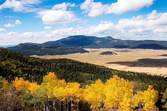
While access and facilities currently are limited at Valles Caldera National Preserve in New Mexico, the landscape is breathtaking and worth the effort to see and explore/NPS
New Mexico Highway 4 climbs steadily, sometimes steeply, west out of Los Alamos, through forests scorched by wildfire in recent decades, and over a pass at the top of Bandelier National Monument. The road drops slightly, then bursts out of the trees. Spread suddenly before us is a vast grassland, the Valle Grande, in Valles Caldera National Preserve, a recent addition to the National Park System. This huge meadow seems the bottom of a bowl, and we are on its south rim. Eleven miles to the north is the north rim of the caldera, rising to 10,000 feet. The 87,000-acre national preserve, established in 2000, was placed under the care of the National Park Service in 2015.
Literally translated as “kettle,” the Spanish word caldera in geology refers to a feature created when magma rushes into a volcanic vent. An explosion results, creating a void in the vent that consequently collapses with an implosion of rock and volcanic material. In the case of the Valles Caldera, the eruption 1.25 million years ago opened “ring fracture vents,” literally a circle of vents that ejected so much material the vent roofs collapsed, dropping thousands of feet, creating the bowl we gaze across from the highway.
Over the ensuing 1.2 million years, lakes formed in the caldera, a resurgent dome emerged, additional volcanism occurred, and gradually the caldera took the form we see today. Standing above the Valle Grande, the largest of three spectacular valles, is 11,254-foot Redondo Peak, the resurgent dome of this volcanic marvel. The geologic story, quite evident to anyone who cares to stop and study the landscape a bit, or talk with a park interpreter, is the defining story of this place, but not the only story.
The bones of the earth in the American Southwest are more visible than in other more deeply vegetated areas, and often the geologic story leaps out at the curious observer. The Southwest is also rich in human prehistory and history, and Valles Caldera National Preserve is no exception. Archaeologists believe humans have lived around the caldera for nearly 13,000 years, with a sparse population of hunter-gatherers moving over the landscape in the climatically cool early stages of habitation, then a gradually increasing population developing agriculture in small villages and eventually pueblos at lower elevations around the caldera. They worked high-quality obsidian, a volcanic glass, into excellent tools that dispersed in trade across, and beyond, the Southwest, turning up as far distant as modern South Dakota.
Spanish moved into the area in the 1600s with their livestock and began grazing the lush valles of the caldera, a practice that continues to the present. Disease, warfare, and other social stresses of the Spanish “invasion” decimated the native Jemez population, reducing it by more than 80 percent. When the United States seized the area from Mexico in 1848, it agreed to honor valid land grants of the Spanish and Mexican government. One land grant “settlement,” in 1860, resulted in nearly the entire caldera being awarded to the heirs of Cabeza de Baca, which became known as the “Baca Land Grant #1.” Private ownership ran through four owners over the next century, and they engaged in logging, grazing, mining, movie-making, and recreational hunting and fishing. Finally, in 2000, after years of negotiation, the U.S. government bought the Baca Grant and it became the Valles Caldera National Preserve.
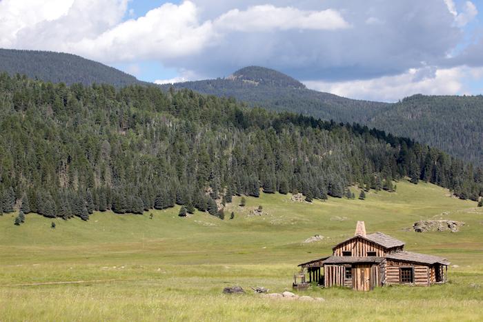
A cabin featured in multiple movies can be seen on the way into the preserve/NPS
Today, nearly half the state of New Mexico is public land, but no part of that domain became public as did the Valle Caldera. Safe to say, the path from private to public land to national preserve is unique in the annals of public land and national park history. First steps along that path were taken in 1963, when Texas oilman James Patrick Dunigan bought the Baca Ranch with ambitions to make it a resort. When Dunigan bought the property, he did not buy the timber rights, and the timber company that owned those rights was aggressively logging the extensive pine forests. By the time Dunigan acquired the timber rights, after extensive court battles, 1,500 miles of logging roads had laced the piney uplands of the caldera (as opposed to the lower valles that were mostly open, grassy meadows with some roads but nothing like the spaghetti-like tangle of those in the uplands).
In the early and mid-20th century, the National Park Service and New Mexico politicians had invested considerable effort to establish a national park in the caldera and surrounding Jemez Mountains and Pajarito Plateau. Proposals had been floated for a Pajarito National Park, a Cliff Cities National Park to include the caldera and Bandelier National Monument, and finally a Jemez Crater National Park. New Mexico Sen. Clinton P. Anderson had introduced a park bill into Congress as late as 1963, but nothing had come of any of these proposals. Dunigan pursued various schemes to profit from acquisition of the Baca Ranch, such as resort developments like a ski area, golf courses, upscale homes, and power development from geothermal wells, but for various reasons, none of these came to fruition. He leased the land for cattle grazing and offered modest outdoor recreation opportunities like elk hunting.
By the late 1970s, the exceptional beauty of the caldera convinced Dunigan that indeed it should be a national park, and he offered to sell the property to the Park Service. But, over the next 20 years, no deal could be forged. In 1990, a lawsuit settlement with the nearby Santo Domingo Pueblo involving the U.S. Forest Service included funding for a study of the feasibility of federal acquisition of the Baca. This kept the spark of the national park idea alive until, in 1997, the Dunigan family indicated they were ready to sell and gave the federal government the first shot at the property. Over the next three years, with support from New Mexico Sen. Jeff Bingaman, the public, and President Bill Clinton, a reluctant New Mexico Sen. Pete Domenici added his support. Funding for the purchase of the property from the Land and Water Conservation Fund was authorized, and the Valles Caldera Preservation Act was approved by Congress. A Valles Caldera National Preserve of 88,900 acres was established, but here the story takes a unique turn.
The preserve was not part of the National Park System. Sen. Domenici, unhappy with federal land management agencies, insisted the preserve be managed as a quasi-privatized, profit-making experiment. A nine-member board, appointed by the president and called the Valles Caldera Trust, was to operate the preserve as a working ranch, the ultimate goal being financial self-sufficiency. The Trust would have 20 years to reach this goal, but after 15 years it was clear that this unusual model of public land management was not working and was, for several reasons, unsustainable. The most important reason was that financial sustainability could only be achieved by maximizing profit from such activities as elk hunting, but to do so would mean charging high prices for recreational activities such as the elk hunt, beyond the reach of local people. The Trust board deemed such exclusivity unacceptable on public land, eliminating profit maximization as a management goal. Other reasons were that regulations and bureaucratic requirements were costly to meet, the Trust was unable to make long-term contracts, and the preserve was within the Forest Service but outside its organizational structure, resulting in a host of administrative complications.
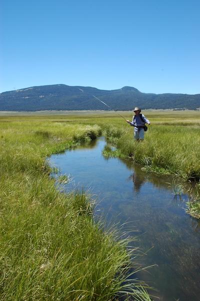
An angler fly fishing along the East Fork of the Jemez River/NPS
When, after 15 years, it became evident that the Valles Caldera Trust experiment was in trouble, Sen. Bingaman initiated an effort to shift authority for the preserve to the National Park Service. The Forest Service was struggling, its budgets and workforce slashed and severely impacted by the growing cost of wildfire management. New Mexico Sens. Tom Udall and Martin Heinrich (Bingaman having retired in 2012) embedded legislation moving the preserve to the Park Service in the 2015 defense spending bill, which was signed that December by President Obama. The idea of a “national park” including Valles Caldera was finally realized, or was it?
The nomenclature of the National Park System clearly differentiates between “national park” and many other types of units, including “national preserve.” In 1974, “national preserve” was added to allow protection of areas of national scenic, recreational, or scientific significance as part of the National Park System. Activities such as hunting, fishing, grazing, even oil and mineral extraction, might be allowed if they did not clash with other protected resource values. Valles Caldera is home to a large herd of elk and has long been a favorite area among elk hunters. The expansive grassy valles have been grazed for hundreds of years, and in a national preserve, such land uses might continue.
Whether these uses will, and to what extent, remains to be seen. In March 2017, the Park Service issued a call for applications for its Valles Caldera Livestock Program. A maximum of 250 AUMs (Animal Units Per Month) might be allowed if environmental conditions permit. The Park Service is also committed to continuing an elk hunt. A year and a half after the Park Service took over, visitation is increasing, interpretation is provided at a modest visitor center. Management planning is under way, as is extensive repair and improvement of infrastructure.
Road access to the area is limited. On a cold, windy, early March visit, I found only the two-mile road to the visitor center open. Ski touring, quite good in January and February, was over, but hiking on the windswept Valle Grande was bracing and offered distant views of grazing elk. Quite a few intrepid souls were out braving the cold wind.
Returning in mid-May, we were among a limited few granted a permit to drive the “backcountry vehicle route,” which gave us access to the Valle San Antonio near the north boundary of the preserve. The Park Service was experimenting with how many vehicles the route could handle without crowding the experience. Coyotes hunted seemingly undisturbed by our presence, raptors abounded, and mountain bluebirds flitted everywhere. Scenery was magnificent despite extensive wildfire burns on the cerros (mountains) flanking the route.
The National Park Service has a challenge ahead in preparing this area for extensive public use. Its management planning will involve many questions about vehicle access, managing the elk hunt and visitors not there to hunt, how best to interpret not only the natural history of this fascinating area but also its complex cultural prehistory and history. Should it build campgrounds and, if so, how many and where? Currently there are no campgrounds in the preserve – backcountry camping is allowed, but front-country campers must go to nearby campgrounds in the Santa Fe National Forest or Bandelier National Monument. Hiking and equestrian trails wind all over the preserve, many traversing parts of the 38,000 acres in the preserve burned in 2011 by the Los Conchas fire, requiring lots of trail work to clear downed trees and repair erosion damage. The road issue will be a tough one – how to ration access to a very limited road system, whether to improve more roads, how to avoid “elk jams,” and other problems that are common in national parks.
The Park Service has inherited an area far from ready to accommodate a rush of visitors. Its facilities are minimal, a boon to some and bane to others. Questions abound regarding priorities and emphasis in managing the area. It has been severely impacted by grazing and especially by logging in its recent history. While the preserve is remarkably scenic with its expansive valles, the landscape healing process will take decades of care and scientifically guided management. This healing process will itself offer a powerful story to be told in this remarkable national treasure.
In addition to beginning from scratch planning this new national park unit, the Park Service has both the challenge and the opportunity of building its programs around the powerful influence of fire on the landscape reaching back 1.25 million years and still forming the biology and geology of this amazing place. It has an opportunity, in close partnership with Bandelier National Monument and the new Manhattan Project National Historic Park in Los Alamos, all administered by the National Park Service, to tell a deep tale of natural and human history, a tale of destruction and reconstruction, of natural and human resilience. Visitors should come to explore the region and its national monument, preserve and historic park. They will not be disappointed by what they find.
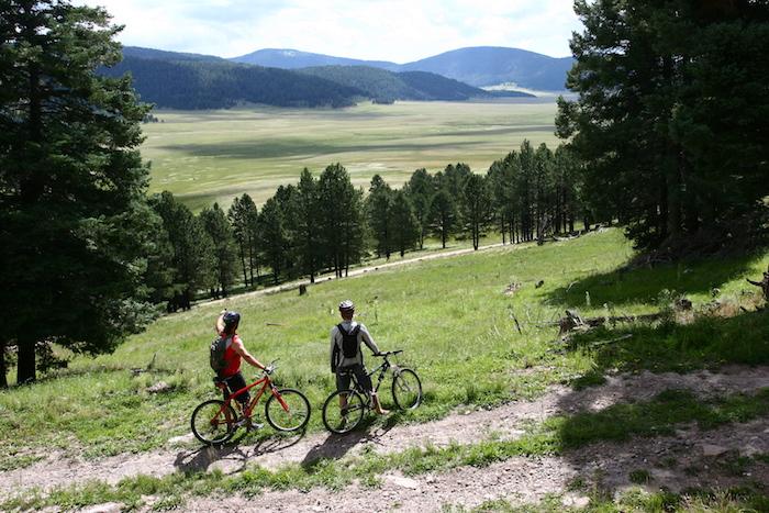
Mountain bikers stop to admire the Valle Grande/NPS


Comments
Thanks for your good write up on the Valles Caldera. It is worth noting that locals pushed Senators Domenici and Bingaman to purchase the Baca Ranch in 2000 and then organized locals pushed hard for 15 years to get the National Park Service in to manage the Valles Caldera and end the semi-private management that Senator Domenici cooked up. Activism matters. Without it this place would be a private ranch with powerlines, cattle and big houses. Get active folks! Help save your favorite place.
One of the most beautiful places I've ever seen. It takes your breathe away as you round the cruve of the highway and the valley falls away from the road. Please help us save it from development. It deserves to remain as it is for all time.