Trip to the Canadian Rockies
- Part 1: Jasper National Park
- Part 2: The Icefields Parkway
- Part 3: Yoho National Park
- Part 4: Banff National Park
Up, up, and farther up.
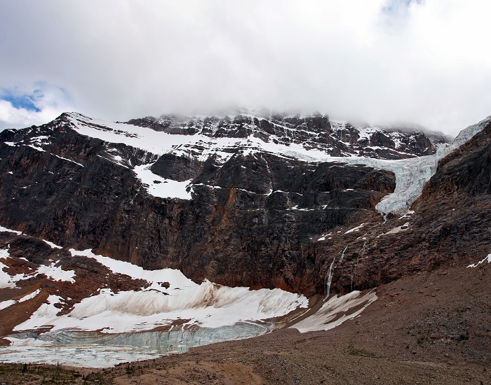
First, north to the heart of the Canadian Rockies. Then, a 9-mile drive on a narrow, twisting road through towering trees. Finally, another half-mile hike over a creek and into the heavens. And there, at the end of the Path of the Glacier Trail, a giant mass of rock reaches into the clouds. Above, Angel Glacier appears to pour out of the face of the mountain, as if from a punchbowl. Below, icebergs fill a pond, the retreat point of another glacier. At the foot of 11,033-foot Mount Edith Cavell, you feel like you’re worshipping in a temple at the top of the world.
A picture-perfect way to cap a long, summer day in Jasper National Park, one of Canada’s crown jewels.
With a media blitz by the National Park Service to Find Your Park during the agency’s 100th anniversary, my wife and I assumed the summer crowds at many U.S. parks would be intense. We hoped crossing the border to the north would offer more breathing room. (At times, we were right.) Although Jasper National Park annually hosts around 2 million visitors, the second-most in Canada (behind Banff), it’s larger than nearby Banff, Yoho and Kootenay national parks combined. There’s more room to spread out, and the farther north you go, the fewer people you’ll see.
So in the first week of July, that’s where our six-day road trip through the Canadian Rockies began, followed by a drive down the Icefields Parkway and stops in Yoho and Banff. Since this was our first visit to the area, we tried to see as many of the most popular sites as possible. But on our first day, after a long drive from Kamloops and a detour to Wells Gray Provincial Park to see some waterfalls and stretch our legs, we drove straight to Jasper townsite to have dinner and orient ourselves before setting up camp south of town.
The adventures would have to wait till morning.
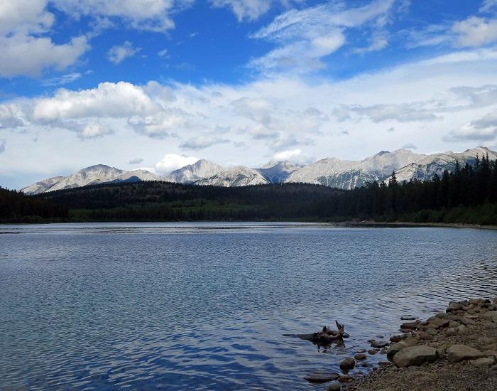
Patricia Lake, just a few miles outside Jasper townsite, offered solitude/Scott Johnson
Jasper townsite
Entering Jasper from the west on the Yellowhead Highway, we passed through an entrance booth similar to one you would find in the U.S. Here, we paid for our entire weeklong visit, with the $9.80 CAD daily admission covering all Canadian national parks. Had we been planning to stay another day, it would have been cheaper to get a Discovery Pass ($67.60 CAD), which is good for entrance to all national parks for 12 months. (Admission to Canada’s national parks will be free in 2017 to commemorate the 150th anniversary of the country’s confederation.) We were given a helpful 20-page brochure with maps and information about attractions and activities. This was the only park in which we received such a “welcome.” Although we entered four parks during the week, we only went through two entrance booths (both in Jasper). At Banff, Yoho and Kootenay, a stop at a visitor center is required to pick up a park pass and informational material.
In Jasper townsite, the Parks Canada information center occupies a beautiful stone building in a park near the center of the city, where you can get advice, information, and free Wi-Fi. Of course, there’s also a gift shop, where I picked up a guidebook to help us plot out our next couple of days. Home to 5,000, Jasper can host up to 20,000 visitors during high season. Still, it was smaller than I envisioned and wasn’t as ritzy or crowded as Banff. Connaught Drive, which lines the edge of the boomerang-shaped town, caters to tourists, with shops and restaurants on one side and visitor parking on the other, though we never had trouble finding a parking spot along the streets. Just a couple of blocks in, the rest of the town appeared to be filled with the homes of locals, though I’m sure many are rented out during the summer.
Eating pizza along Connaught, we watched a train pass by for seemingly our entire meal. Trains are a common sight, as railroad companies were crucial to establishing the town and its surrounding park in the early 1900s. The townsite is a convenient hub for many of the area’s attractions, with Miette Hot Springs and Jasper Lake to the north, Maligne Lake (and Maligne Canyon) to the east, the Icefields Parkway to the south, and Mount Robson to the west. In addition, there are numerous lakes close to town, which can be reached by car or a network of hiking trails.
We knew we didn’t have time to see everything, so as we dug into our book and brochures, it became evident that we wouldn’t be able to revisit Mount Robson, and we decided to pass on Miette Hot Springs, nearly 40 miles farther north. That still left a busy first full day.
Maligne Valley
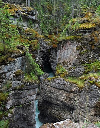
The Maligne River has formed a narrow, twisting canyon through limestone/Scott Johnson
For good reason, the 27-mile drive through Maligne Valley, accessed just a few miles east of Jasper townsite, is one of the most popular destinations in the park. After all, there’s a trail above and across a picturesque, 160-foot deep canyon, a disappearing lake, and, at the end, the largest natural lake in the Canadian Rockies. Along the way, the road hugs the slopes of the Queen Elizabeth Ranges. Budget at least a half-day to take in the highlights, though with a picnic, a hike, and a boat tour, you could easily fill an entire day.
We set out from camp first thing in the morning, opting to skip a turnoff for Lake Edith and Lake Annette in order to get to Maligne Canyon early. From the main trailhead, the 2.5-mile, mostly flat out-and-back is a pleasant walk through Douglas fir and white spruce. According to Parks Canada, some geologists think parts of the canyon were originally deep caves that have been uncovered by glacial scraping and water erosion. The trail hugs the top of the limestone gorge, crossing from time to time where it narrows. In many places, the fence is a mere foot or two inset from a drop straight down, allowing those without a fear of heights to peer deep down into the abyss.
A handful of bridges afford a chance to view both sides of the canyon as well as the Maligne River, which squeezes through openings sometimes only a few feet wide. In some places, the river carved out elegant, arched recesses reminiscent of an apse with calm pools at the bottom. In other spots, the roar became louder and the water more violent. One of the bridges crosses directly over Maligne Falls, where you can feel the spray that mourishes moss and fern growth on the canyon walls and nearby trees. This is a good spot to turn around.
Back on the road, we drove past Medicine Lake and, after negotiating a bear jam, arrived at Maligne Lake. To help understand its size, consider that the road through the valley and to the lake’s outlet is 27 miles long. From here, Maligne Lake snakes nearly 14 miles farther, or more than half the length of the drive, to its meltwater source of Coronet Glacier. Many points of interest, including a photo op of Spirit Island more than halfway down the lake, can only be reached by boat. Tours, which last 90 minutes, are the only gasoline-powered way to reach the island, although visitors can launch their own kayaks and canoes, in addition to renting one.
By the time we arrived in the late morning, clouds and a chilly wind had rolled in, which wasn’t ideal for getting on the water. We opted for a 2-mile hike along the Mary Schaffer Loop, which follows the eastern lakeshore for about a mile to a lookout with a view down the lake to the mountains that feed it. As two tour boats passed each other and rain fell in the distance, I didn’t regret skipping the tour, though I also didn’t realize how little of the lake I was seeing at the time. From here, the trail loop back to the parking lot was a fairly boring walk through the woods, so you might consider returning the way you came, with great lakeside views.
Back in the parking lot, we ate lunch in our car. Had we known the rain was going to relent, we would have waited to picnic at Medicine Lake, halfway along the road back toward town. In early June, this was a bona fide and sizable lake, but that’s not always the case. Fed by glacial melt and the Maligne River, there is no visible outlet to Medicine Lake. Yet in the fall and winter, the lake literally disappears into the ground. Sink holes drain the water into an underground cave system, leaving behind pools, a stream, and a big mudflat. The water eventually resurfaces at Maligne Canyon, where we started our day.
A ring around the lake showed that we were not there at its fullest, but that left plenty of room for kids to run around and for families to enjoy a snack. Sawtooth peaks of the Colin Range appeared to rise right out of the lake’s northeast shore, while gentler, tree-covered hills rose on the opposite side. The recent Excelsior Fire left charred, red trees on the hills, and purple and yellow wildflowers lined parts of the shore.
With more lakes to discover, though, we didn’t linger long.
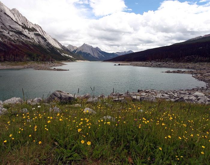
Medicine Lake drains through underground caves and seemingly disappears beginning late summer/Scott Johnson
North of Jasper townsite
We set aside the afternoon to explore the area north of town known as the Pyramid Bench. A short road passes multiple access points to a trail system that connect a handful of lakes, though you could also hike or bike uphill from town. Once there, you can also fish, rent a kayak or canoe, or go for a horseback ride.
The road ends (though the trails don’t) at Pyramid Lake, named after the triangle-shaped mountain that towers above it. One of the lake’s coolest features is a small island that’s accessible via a footbridge, where we felt the icy chill of wind blowing over the water. A 15-minute loop trail includes a picnic shelter, a view of distant Mount Edith Cavell, and an up-close look at Pyramid Mountain.
We started back downhill to find a short trail to Patricia Lake, just below Pyramid Lake. However, we got all the way back to town and didn’t see the trailhead. Back up we went, then down again, rechecked our map, and off to a side road, all without finding the starting point. So here’s the trick: If you’re looking for Trail 6 to Patricia Lake, don’t expect a sign for it. Well, there is a sign for “Patricia,” but that only had parking for rental guests. Look for the big “Horseback Riding” sign and turn there to reach the lot (P5) where the trail begins (and where you can rent a horse).
The trail itself was chewed up by the aforementioned horses, particularly after rainfall, with plenty of tree roots ready to grab your ankles. However, the reward after a short walk was a peaceful, rocky beach with a slightly different perspective of Pyramid Mountain. Less than five miles from town, we had this stretch of shore to ourselves. Perhaps because nobody could figure out how to get there.
With afternoon fading, we stopped in Jasper for dinner and to pick up all the supplies we needed to make S’mores back at camp.
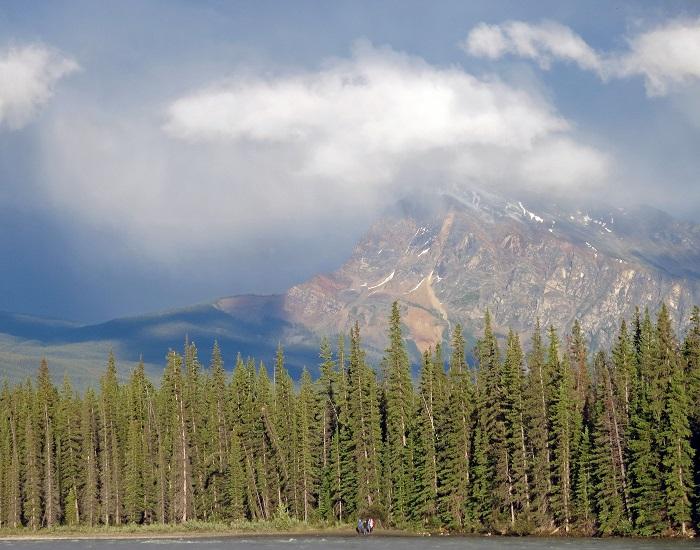
At Wabasso Campground, a trail lines the Athabasca River and offers mountain views/Scott Johnson
Athabasca Parkway
There are plenty of lodging options in Jasper townsite (hotels, hostel, private rooms) and more than 1,000 campsites within five miles, but we chose to stay two nights at the Wabasso Campground ($21.50 CAD per night), just 10 miles south of town on the Athabasca Parkway (Highway 93A). Wabasso’s 200-plus spots were full (or very close to it) during our stay, but it never felt crowded. The sites were spacious and the bathrooms (flush toilets but no showers) clean, and a stack of wood sat at the ready upon our arrival (included with the $8.80 CAD permit required nightly to build a campfire). Our neighbor offered his ax for us to make kindling. We spotted a black bear along the road only a mile or so from the campground. While you don’t need to use a bear locker or hang your food, anything edible should be kept in a vehicle when you’re not eating.
We camp light, with just a two-person tent, and spend most of our time out and about, so amenities are not our top priority. But a nice aspect of Wabasso is a hiker/biker path on the banks of the raging Athabasca River, with mountains visible in three directions. Our site in Loop C was a stone’s throw from the river, so a beautiful sunset was only a couple minutes from our tent.
Thanks to the long summer days, with the sun not setting till well past 10, we had enough time for the trip to Mount Edith Cavell before turning in for the night. I would have liked to get closer to the glacial pool, but access is signed off quite a distance away due to unstable terrain. For a longer walk, the trail also forks to a higher viewpoint from a meadow, but we passed due to the time and a bear warning (one grizzly apparently didn’t take kindly to sharing the trail with hikers).
Although Edith Cavell is the queen of Jasper’s mountains, many more breathtaking peaks awaited us the next day on the Icefields Parkway.

Abstract shapes line the glacial pond at the foot of Mount Edith Cavell/Scott Johnson


 Support Essential Coverage of Essential Places



Comments
My wife and I visited Jasper only one month ago. We marveled at the majestic beauty all about, and were especially excited to come across a black bear with two cubs during a hike one day. We'll not soon forget this trip.
Great images to go along with the article.