Constructions of docks and boathouses are proposed along the Potomac River/NPS
In an effort to provide more recreational opportunities such as rowing, paddling, and stand-up paddleboarding, Chesapeake & Ohio Canal National Historical Park and Rock Creek Park are proposing development of multiple facilities to improve access to the Potomac River in the Georgetown area of the District of Columbia.
Multiple boathouses and docks are proposed to improve access to the river. In addition to water activities, the plan would improve the Capital Crescent Trail, which is popular with pedestrians and cyclists, and add public plazas along the riverfront. Comments on the proposal and environmental assessment are being accepted through Sept. 30.
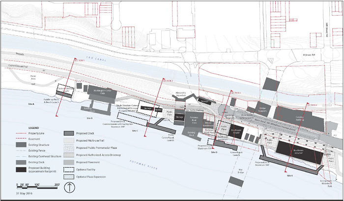
The plan divides the nonmotorized zone into five segments and outlines the phased development:
- Site A would include shoreline improvements, a sloped shoreline launch for canoes/kayaks/paddleboards, a picnic area that could include tables and grills or other amenities, and a trail/boardwalk through the site. Based on future need, site development may include the option of constructing a small, single-story boat storage area with a footprint of no greater than approximately 2,700 square feet.
- The Washington Canoe Club and its facilities are located within Site B. The only actions proposed on this site would include general site restoration, rehabilitation of the structure, reconfiguring or removing the fenced yard, altering the authorized access driveway so that it services the facility, and providing controlled public access across the Washington Canoe Club apron to Site A.
- Site C would provide a canoe/kayak rental/storage facility that could be one single structure or multiple smaller structures. The total facility footprint would be no greater than approximately 6,000 square feet with no more than two stories and a maximum height of 35 feet. The size of the adjoining public apron and dock would be commensurate with the ultimate size of the new facility or facilities, but not longer than 300 feet.
- The primary configuration of the boathouse facility at Site D assumes that the privately owned townhouses would remain in private ownership and be excluded from the nonmotorized boathouse zone. Therefore, Site D would include the construction of a smaller boathouse with an approximate footprint of 3,600 square feet (possibly up to 4,200 square feet, although a boathouse that size would restrict boat maneuverability in the plaza), a dock up to 150 feet long, a plaza, and ground-level boat storage. Both the dock and plaza areas would be accessible to the public except during permitted events (i.e., regattas and team practices). The proposed boathouse could be designed for a maximum height of 45 feet or up to three stories. If the townhouses were to become available for inclusion in the project at some point in the future, options for a larger boathouse (7,200 square feet) on that site, with the public plaza shifted to the west, could be considered.
- Site E would include construction of a large boathouse with a footprint of up to approximately 13,800 square feet, with a dock up to 300 feet long, ground-level storage, and plaza areas. Both the dock and plaza areas would have public access except during permitted events (i.e., regattas and team practices). Treatments and configurations for Water Street NW and links between the CCT, the street, and Georgetown Waterfront Park would include drop-off and temporary storage areas for car-top users to leave their boats while they park on Water Street NW or in a parking garage. The site would also include an apron with vehicular access from Water Street NW at 34th Street NW and a public plaza/apron with dock access at the west end of the boathouse.
To comment
- Deadline: Sept. 30, 2016
- Online: http://parkplanning.nps.gov/nmbzea_comments
- Mail: Tammy Stidham, National Park Service, National Capital Region, Attention : NMBZ EA, 1100 Ohio Drive SW, Washington, DC 20242


Add comment