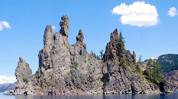
A visit to Crater Lake National Park should include a close-up view of Phantom Ship, an ancient volcanic plug/Kurt Repanshek
Washington State tends to lure visitors interested in volcanic features, but the two states immediately to the south shouldn't be overlooked.
Lassen Volcanic National Park in California and Crater Lake National Park in Oregon both have eruptive pasts, the remains of which are readily apparent. Today these two national parks are showcases for the Earth's fiery fury.
Both are located along the Volcanic Legacy Scenic Byway, which runs 500 miles: Lassen anchoring the southern end in California and Crater Lake the northern terminus in Oregon.
Start your drive at Crater Lake and you will see one of the most beautiful sights in the country. This blue jewel is cradled in the crater left by the eruption of prehistoric Mount Mazama. This magma chamber erupted over two days; the mountain then collapsed and the resulting crater filled with azure-hued water to a depth of almost 2,000 feet.
Don't just roam the rim and gaze at the water though. A visit to Crater Lake should include a boat trip on the lake, too. The half-day cruise includes a stop at Wizard Island, a volcanic crater inside the larger crater, and a slow circumnavigation of Phantom Ship.
Stay at Crater Lake Lodge, or down in Mazama Village, and spend a few days exploring the park's primeval forests. A nice easy hike is the Castle Crest Wildflower Trail. Located less than a quarter-mile from the start of the East Rim Drive across from park headquarters, this half-mile loop trail takes you through meadows bursting with wildflowers (supposedly more than 200 species), a small gurgling creek, and rimming forests of mountain hemlock, Lodgepole pine, subalpine fir, and Shasta red fir. It was built as a Boy Scout project back in 1929.
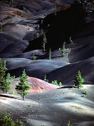
Ash and cinder fields at Lassen Volcanic Park show the slow recovery of the landscape/Patrick Cone
Less than 225 miles south, via U.S. 97 and California 89, Lassen Volcanic National Park is another, more recent, geologic wonder. It's a surprisingly -- and wonderfully -- uncrowded park wrapped around a peak that unleashed its volcanic fury a number of times from 1914-1917. The most violent of the blasts, on May 22, 1915, sent a super-heated pyroclastic flow down the peak and created today's Devastated Area.
There's a trail through the Devastated Area that could better be called a geologic trail. It roams only about a half-mile, but within that half-mile, you're presented with the aftermath of the volcanic eruptions (there was one on May 19, and two on May 22) that rained down rocks and boulders, mud, and hot gases -- a pyroclastic flow -- more than 2 miles from the peak. Photos taken by B.F. Loomis show the route the majority of the largest blast took on May 22 clearing a wide path through forests. At the time, U.S. Forest Service officials estimated that the eruption knocked down 5 million board feet of timber.
While Lassen Peak is the main attraction in the park, it is just one of four volcanoes to be found here. Lassen Peak is a plug dome volcano (one created by lava pressure around a vent), but there are also shield, composite, and cinder cone volcanoes within the park's boundaries.
Lodging consists of some Spartan rental cabins
For an added bonus, stop by Lava Beds National Monument, conveniently located half-way between Crater Lake and Lassen Volcanic, and explore the monument's underbelly by touring some of its caves. Sign up for the Fern Cave Tour and see ancient pictographs that trace the cultural history of the area back thousands of years.
Stories about:
Story Categories:
A copy of National Parks Traveler's financial statements may be obtained by sending a stamped, self-addressed envelope to: National Parks Traveler, P.O. Box 980452, Park City, Utah 84098. National Parks Traveler was formed in the state of Utah for the purpose of informing and educating about national parks and protected areas.
Residents of the following states may obtain a copy of our financial and additional information as stated below:
- Florida: A COPY OF THE OFFICIAL REGISTRATION AND FINANCIAL INFORMATION FOR NATIONAL PARKS TRAVELER, (REGISTRATION NO. CH 51659), MAY BE OBTAINED FROM THE DIVISION OF CONSUMER SERVICES BY CALLING 800-435-7352 OR VISITING THEIR WEBSITE. REGISTRATION DOES NOT IMPLY ENDORSEMENT, APPROVAL, OR RECOMMENDATION BY THE STATE.
- Georgia: A full and fair description of the programs and financial statement summary of National Parks Traveler is available upon request at the office and phone number indicated above.
- Maryland: Documents and information submitted under the Maryland Solicitations Act are also available, for the cost of postage and copies, from the Secretary of State, State House, Annapolis, MD 21401 (410-974-5534).
- North Carolina: Financial information about this organization and a copy of its license are available from the State Solicitation Licensing Branch at 888-830-4989 or 919-807-2214. The license is not an endorsement by the State.
- Pennsylvania: The official registration and financial information of National Parks Traveler may be obtained from the Pennsylvania Department of State by calling 800-732-0999. Registration does not imply endorsement.
- Virginia: Financial statements are available from the Virginia Department of Agriculture and Consumer Services, 102 Governor Street, Richmond, Virginia 23219.
- Washington: National Parks Traveler is registered with Washington State’s Charities Program as required by law and additional information is available by calling 800-332-4483 or visiting www.sos.wa.gov/charities, or on file at Charities Division, Office of the Secretary of State, State of Washington, Olympia, WA 98504.
