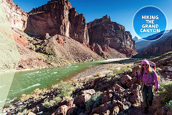
My 10-year-old daughter, Alex, and I follow the steep and rugged New Hance Trail on a nearly 5,000-vertical-foot march down into the Earth's most-famous hole in the ground. The sky seems to levitate steadily higher above us, but it's just a trick played on the eyes by the severe topography of the Grand Canyon: As we slowly descend deeper, burgundy rock walls creep higher, pushing the cerulean dome overhead farther away from us. In the distance, thousand-foot-tall stone towers stretch toward that sky, yet still fall short of the heights of the canyon's North Rim, miles away.
We hike comfortably in shirtsleeves and warm sunshine that does not feel like the heat of a nuclear reaction that I have experienced on every previous hike here. And I have to keep reminding myself that this is the first weekend of November, a time of year we don't normally associate with mild-weather, outdoor adventures in national parks.
That evening, as Alex and I sit in our campsite listening to the gravelly rumble of the Colorado River rolling past nearby, and looking up at the kind of star-riddled sky that we rarely see in the communities where most Americans live today, I realized that this trip answers two related questions for national parks lovers:
What's the best time to visit Grand Canyon National Park for comfortable temperatures and no crowds?
And where do you go in late autumn, when many parks are getting cold, wet weather, or starting to accumulate their winter layer of snow?
September through the first half of October, like April through the first half of May, is a popular time to visit and hike in the Big Ditch. But mid-October through mid-November also consistently delivers dry weather and temperatures ranging from highs in the 50s on the rims and the 60s or low 70s in the canyon bottom, to lows around freezing on the rims (typically early morning, warming quickly when the sun comes up) but in the 50s near the river. The summer 'monsoon' rains have passed, and while snow may fall at the rims, it typically doesn't start sticking until later in November.
While days are short and services at the North Rim close by mid-October, South Rim trails that can teem with hikers during peak seasons become quieter in late autumn, and permits for backpacking trips easier to obtain. The following day hikes and backpacking trips routes, all originating on the South Rim, are great choices from mid-October through mid-November. Remember that water sources are scarce to non-existent, and don't underestimate how much more strenuous it is to turn around and ascend the distance and elevation you've easily descended.
Day Hikes
The Bright Angel Trail, like the South Kaibab Trail one of the park's best-maintained' and safest''corridor' paths, zigzags down through a broad, side canyon below soaring cliffs, with long views across the canyon. From Grand Canyon Village, it drops 3,000 feet in 4.8 miles to Indian Garden, a good turnaround point for fit, prepared day-hikers or a shaded watering hole for an overnight hike of moderate difficulty. Views are constant and there are other landmarks along the trail creating natural turnaround points for shorter hikes.

South Kaibab Trail below Cedar Ridge/NPS
The South Kaibab Trail deservedly earns a spot on many lists of the most scenic hikes in America. From the trailhead near Yaki Point east of Grand Canyon Village (no parking available; take the park's free shuttle bus), the South Kaibab snakes down along the crest of a ridge'the only trail in the park that follows a ridge top'offering unparalleled, 360-degree panoramas of the canyon virtually every step of the way. Popular turnaround points for day-hikers are Cedar Ridge (three miles and 1,140 feet round-trip); Skeleton Point (six miles, 2,040 feet round-trip); and the Tipoff (8.8 miles and 3,260 feet). Catch the first shuttle bus in the morning for beautiful early light and few other hikers until you're coming back up.
The Grandview Trail is one of those cliffhugging footpaths that can be terrifying in snowy and icy conditions of early spring and exciting and safe in the dry conditions typical from mid-April to mid-November. (I've hiked it in both conditions'both times with my daughter.) It offers views comparable to the Bright Angel and South Kaibab (if not quite matching the latter), but without the crazy volume of people. Turn back at Coconino Saddle (2.2 miles, 1,190 feet round-trip) or Horseshoe Mesa (six miles, 2,500 feet).
Backpacking
The South Kaibab Trail to Bright Angel Trail hike is the iconic Grand Canyon backpacking trip, making it a difficult permit to come by during peak times in spring and fall. Descend the South Kaibab seven miles and 4,780 feet to Bright Angel Campground, where you'll probably spend a pleasantly mild evening even in the first half of November. Then spread the 9.5-mile, 4,580-foot ascent of the Bright Angel Trail out over two days with an overnight at Indian Garden.
Probably second in popularity only to the South Kaibab Trail to Bright Angel Trail backpacking route (above), hiking 24.8 miles from Hermit Trailhead to Bright Angel Trailhead delivers an experience similar to the former without the difficulty of hiking all the way down to the canyon bottom and back up. The Hermit and Bright Angel trails offer the expansive, upper-canyon views'and the strenuousness of big elevation gain and loss'while the traverse of the gentler Tonto Trail linking them gives you a physical respite with mid-canyon vistas of breathtaking red-rock amphitheaters. Spread the trip over three to four days and check with backcountry rangers about water availability.
The 29.2-mile, Grandview Point to South Kaibab Trailhead trip matches the scenery of the Hermit Trailhead to Bright Angel Trailhead hike, but sees fewer hikers even during peak times of the year'perhaps mostly due to the exposure on parts of the upper Grandview Trail. It's also, in my opinion, a little more spectacular. Take three to four days, and check beforehand with backcountry rangers on how many of the four reliable water sources are flowing; some of them dry up every fall.
For Grand Canyon climate information, see nps.gov/grca/planyourvisit/ weather-condition.htm.
See Grand Canyon trail descriptions at nps.gov/grca/planyourvisit/campsiteinformation. htm.
Map Grand Canyon East no. 262 and Grand Canyon West no. 263, $11.95 each, (800) 962-1643, natgeomaps.com.
Contact Grand Canyon National Park, (928) 638-7888, nps.gov.grca
Story Categories:
A copy of National Parks Traveler's financial statements may be obtained by sending a stamped, self-addressed envelope to: National Parks Traveler, P.O. Box 980452, Park City, Utah 84098. National Parks Traveler was formed in the state of Utah for the purpose of informing and educating about national parks and protected areas.
Residents of the following states may obtain a copy of our financial and additional information as stated below:
- Florida: A COPY OF THE OFFICIAL REGISTRATION AND FINANCIAL INFORMATION FOR NATIONAL PARKS TRAVELER, (REGISTRATION NO. CH 51659), MAY BE OBTAINED FROM THE DIVISION OF CONSUMER SERVICES BY CALLING 800-435-7352 OR VISITING THEIR WEBSITE. REGISTRATION DOES NOT IMPLY ENDORSEMENT, APPROVAL, OR RECOMMENDATION BY THE STATE.
- Georgia: A full and fair description of the programs and financial statement summary of National Parks Traveler is available upon request at the office and phone number indicated above.
- Maryland: Documents and information submitted under the Maryland Solicitations Act are also available, for the cost of postage and copies, from the Secretary of State, State House, Annapolis, MD 21401 (410-974-5534).
- North Carolina: Financial information about this organization and a copy of its license are available from the State Solicitation Licensing Branch at 888-830-4989 or 919-807-2214. The license is not an endorsement by the State.
- Pennsylvania: The official registration and financial information of National Parks Traveler may be obtained from the Pennsylvania Department of State by calling 800-732-0999. Registration does not imply endorsement.
- Virginia: Financial statements are available from the Virginia Department of Agriculture and Consumer Services, 102 Governor Street, Richmond, Virginia 23219.
- Washington: National Parks Traveler is registered with Washington State’s Charities Program as required by law and additional information is available by calling 800-332-4483 or visiting www.sos.wa.gov/charities, or on file at Charities Division, Office of the Secretary of State, State of Washington, Olympia, WA 98504.
