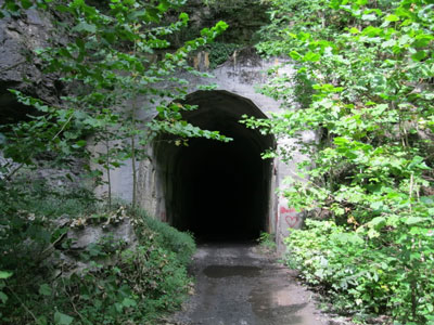
The entrance to the old Carnifex Tunnel. NPS photo.
An abandoned railroad tunnel in the Gauley River National Recreation Area offers a real-world example of a dilemma faced by every park manager: how to balance convenience and existing uses with safety and limited dollars. The Carnifex Tunnel receives occasional use by the park staff and the public—mostly local residents—but an inspection by engineers found crumbling ceilings in the old tunnel.
The decision in this situation--to close the tunnel--may not be popular with everyone, but it's a case where safety trumps convenience.
The Carnifex Tunnel is part of an old railroad grade along the Meadow River, a tributary of the Gauley River in West Virginia. According to a park spokesperson, "This area of the rail grade / tunnel is primarily used by local hunters to reach hunting leases on private land. Park Visitor and Resource Protection staff has historically used this route for emergency access to the Meadow River."
Any man-made structure requires regular maintenance, but it's been years since this tunnel was used by a railroad, and there's been no compelling reason for anyone else to invest in expensive repairs. Federal Highway Administration (FHA) engineers inspected the tunnel last fall and found the crumbling ceiling caused unsafe conditions for pedestrian and vehicle traffic.
No Easy Fix Available
After the FHA inspection last fall, the park posted "enter at your own risk" signs at the tunnel entrances while the staff investigated options for repairs. The staff looked at a short term fix—knocking down the loose concrete from the ceiling—but this was not found to be a viable solution, since it would only provide a temporary repair to a much larger problem.
That potential "band aid" solution raised an even greater concern: it did not provide any reasonable assurance that the tunnel was safe for visitor and employee use. Due to the extensive drainage issues and structure fractures, it is inevitable that additional damage would continue to occur during rain events and freeze / thaw cycles, requiring further, and ongoing, repairs.
Based on information from the FHA engineers, any long-term fix for the problem was found to be cost prohibitive, especially in view of the limited use of the tunnel and the size of the job; one souce says the tunnel is about 1,000 feet long. The solution will be a permanent closure of the tunnel, and that work will be completed by the end of this month.
Safety Trumps Convenience
Park superintendent Trish Kicklighter sums up the rationale for the decision:
"The tunnel is too unsafe for visitors and employees to use. Signing alone will not deter people from using the tunnel and visitor and employee safety has to be our highest priority. The National Park Service holds the safety of visitors and community members as a top concern," Kicklighter said. "We apologize for any inconvenience this may cause for the local community."
The superintendent's comment also illustrates another challenge for park managers: how much effort and expense is "enough" when it comes to warning visitors about unsafe situations? When warning signs aren't getting results, and the risks are serious ones, how far should a park go to try to discourage—or prevent—the public from putting themselves, and those who would have to try to rescue them in case of trouble, in danger?
In the case of this tunnel, a closure seems to be the most responsible solution.
Another example of such decisions occurred in the 1980s at the Buffalo National River in Arkansas, where long-abandoned zinc mining tunnels in the park's Rush Historic District posed both considerable danger, and a temptation, for some visitors.
In 1984, a mine safety inspector from the Office of Mine Safety and Health Administration and park staff conducted an on-site inspection of the mines, and found plenty of problems: large, loose ceiling rocks; deep, water-filled pits; and signs of recent cave-ins in several tunnels.The park posted warning signs and erected fencing and gates to block the entrances to the crumbling tunnels, and those measures have been generally effective in keeping all but the most foolhardy out of harm's way.
The Park Looks to Short-term and Long-Term Alternatives
The good news for hunters and other visitors who have been using the Carnifex Tunnel at Gauley River is that an alternate route to access lands along the Meadow River does exist. According to the park, the section of the rail grade upriver from the tunnel can be reached from Shawver Bridge Road.
In the long term, the park plans to build a pedestrian and bike trail around the tunnel so the rail grade can provide access up and down the Meadow River and connect to Fayette County's proposed Rail Trail. That sounds like a much better investment of scarce dollars than attempting to make ongoing repairs to the deteriorating railroad tunnel.
Gauley River National Recreation Area is managed and administered by the staff of New River Gorge National River, and includes 25.5 miles of the Gauley River and 5.5 miles of the Meadow River. There are currently 4,092 acres in NPS ownership.
The area is best-known for its river trips. According to the park's website, the Gauley River drops "more than 668 feet through 28 miles of rugged terrain; the Gauley River's complex stretch of whitewater features more than 100 rapids with a steep gradient, technical runs, an incredible volume of water and huge waves."
You'll find more information about Gauley River National Recreation Area on the park website. The area, including the tunnel, is shown on the northern portion of the map for the New River Gorge National River.
Story Categories:
A copy of National Parks Traveler's financial statements may be obtained by sending a stamped, self-addressed envelope to: National Parks Traveler, P.O. Box 980452, Park City, Utah 84098. National Parks Traveler was formed in the state of Utah for the purpose of informing and educating about national parks and protected areas.
Residents of the following states may obtain a copy of our financial and additional information as stated below:
- Florida: A COPY OF THE OFFICIAL REGISTRATION AND FINANCIAL INFORMATION FOR NATIONAL PARKS TRAVELER, (REGISTRATION NO. CH 51659), MAY BE OBTAINED FROM THE DIVISION OF CONSUMER SERVICES BY CALLING 800-435-7352 OR VISITING THEIR WEBSITE. REGISTRATION DOES NOT IMPLY ENDORSEMENT, APPROVAL, OR RECOMMENDATION BY THE STATE.
- Georgia: A full and fair description of the programs and financial statement summary of National Parks Traveler is available upon request at the office and phone number indicated above.
- Maryland: Documents and information submitted under the Maryland Solicitations Act are also available, for the cost of postage and copies, from the Secretary of State, State House, Annapolis, MD 21401 (410-974-5534).
- North Carolina: Financial information about this organization and a copy of its license are available from the State Solicitation Licensing Branch at 888-830-4989 or 919-807-2214. The license is not an endorsement by the State.
- Pennsylvania: The official registration and financial information of National Parks Traveler may be obtained from the Pennsylvania Department of State by calling 800-732-0999. Registration does not imply endorsement.
- Virginia: Financial statements are available from the Virginia Department of Agriculture and Consumer Services, 102 Governor Street, Richmond, Virginia 23219.
- Washington: National Parks Traveler is registered with Washington State’s Charities Program as required by law and additional information is available by calling 800-332-4483 or visiting www.sos.wa.gov/charities, or on file at Charities Division, Office of the Secretary of State, State of Washington, Olympia, WA 98504.
INN Member

The easiest way to explore RV-friendly National Park campgrounds.

Here’s the definitive guide to National Park System campgrounds where RVers can park their rigs.
Our app is packed with RVing- specific details on more than 250 campgrounds in more than 70 national parks.
You’ll also find stories about RVing in the parks, tips helpful if you’ve just recently become an RVer, and useful planning suggestions.
