The Moose-Wilson Road in Grand Teton National Park is a thin, two-lane ribbon running through a gorgeous part of the park. It's a particularly scenic way to enter the park, especially in fall when the vegetation is changing colors and the bears come to gorge themselves on ripe berries.
But how should it be managed long-term? That can be a good question in the fall, when the road can become jammed with vehicles and visitors looking to photograph bears, moose, and any other wildlife that appears.
Through February 6 the park is taking input on what should be considered as a comprehensive management plan/environmental impact statement for the Moose-Wilson corridor is developed. The purpose of the document is to determine how best to provide appropriate opportunities for visitors to use, experience, and enjoy the Moose-Wilson area while protecting park resources and values.
During the scoping period, Grand Teton officials are seeking input from the public on significant issues, alternatives, concerns, opportunities, or topics that should be addressed during the planning effort. The Plan/EIS will consider a range of alternatives for the corridor’s future management and will analyze potential environmental impacts associated with each alternative. Additional opportunities for public involvement will also be provided at other stages of the planning process.
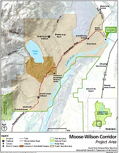
The Moose-Wilson corridor comprises about 10,300 acres in the southwest corner of Grand Teton National Park. This exceptional area has a remarkable variety of natural communities, cultural and wilderness resources, and opportunities for visitor enjoyment. The Moose – Wilson Road extends 7.7 miles through the area, and is the primary access to several park destinations, including Death Canyon and Granite Canyon trailheads, Laurance S. Rockefeller Preserve, White Grass Ranch, and Murie Ranch historic districts, and Sawmill Ponds overlook.
The corridor highlights the rich history of working ranches and the beginnings of conservation work, and provides exceptional opportunities for wildlife viewing. Developing a comprehensive management plan for the corridor is critical to ensure the protection of key resources, values, and visitor experience for the enjoyment of this and future generations.
An open house on the planning effort is scheduled for January 14 from 5 p.m.-8 p.m. in the Moose-Wapiti Classroom at St. John’s Medical Center in Jackson, Wyoming. Additional information, including a scoping newsletter is available at this site. A copy of the newsletter can be downloaded through that website, and comments can be provided electronically online.
Story Categories:
A copy of National Parks Traveler's financial statements may be obtained by sending a stamped, self-addressed envelope to: National Parks Traveler, P.O. Box 980452, Park City, Utah 84098. National Parks Traveler was formed in the state of Utah for the purpose of informing and educating about national parks and protected areas.
Residents of the following states may obtain a copy of our financial and additional information as stated below:
- Florida: A COPY OF THE OFFICIAL REGISTRATION AND FINANCIAL INFORMATION FOR NATIONAL PARKS TRAVELER, (REGISTRATION NO. CH 51659), MAY BE OBTAINED FROM THE DIVISION OF CONSUMER SERVICES BY CALLING 800-435-7352 OR VISITING THEIR WEBSITE. REGISTRATION DOES NOT IMPLY ENDORSEMENT, APPROVAL, OR RECOMMENDATION BY THE STATE.
- Georgia: A full and fair description of the programs and financial statement summary of National Parks Traveler is available upon request at the office and phone number indicated above.
- Maryland: Documents and information submitted under the Maryland Solicitations Act are also available, for the cost of postage and copies, from the Secretary of State, State House, Annapolis, MD 21401 (410-974-5534).
- North Carolina: Financial information about this organization and a copy of its license are available from the State Solicitation Licensing Branch at 888-830-4989 or 919-807-2214. The license is not an endorsement by the State.
- Pennsylvania: The official registration and financial information of National Parks Traveler may be obtained from the Pennsylvania Department of State by calling 800-732-0999. Registration does not imply endorsement.
- Virginia: Financial statements are available from the Virginia Department of Agriculture and Consumer Services, 102 Governor Street, Richmond, Virginia 23219.
- Washington: National Parks Traveler is registered with Washington State’s Charities Program as required by law and additional information is available by calling 800-332-4483 or visiting www.sos.wa.gov/charities, or on file at Charities Division, Office of the Secretary of State, State of Washington, Olympia, WA 98504.
INN Member

The easiest way to explore RV-friendly National Park campgrounds.

Here’s the definitive guide to National Park System campgrounds where RVers can park their rigs.
Our app is packed with RVing- specific details on more than 250 campgrounds in more than 70 national parks.
You’ll also find stories about RVing in the parks, tips helpful if you’ve just recently become an RVer, and useful planning suggestions.
