More than a month after a storm battered Guadalupe Mountains National Park in Texas crews are still assessing and repairing damage to the trail system.
The storm that struck September 11-13 dumped more than a foot of rain on parts of the park. The deluge washed out trails and damaged facilities.
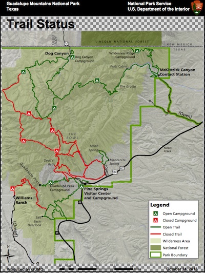
As of Friday, approximately 65 percent of park trails had been reopened. Crews have repaired and opened the entire Smith Spring Trail and completed repairs to the Frijole Ranch Cultural History Museum. The museum will be staffed on weekends, and intermittently on weekdays.
Horseback riding is now allowed on trails from Dog Canyon. However, stock trails in the rest of the park remain closed, due to safety concerns. Open facilities include:
- Pine Springs Visitor Center and Campground (RV and Tent Camping)
- Dog Canyon Ranger Station and Campground (RV and Tent Camping)
- Frijole Ranch, including the Frijole Ranch Cultural History Museum
- McKittrick Canyon Visitor Contact Station
- Guadalupe Peak, Wilderness Ridge, Marcus, McKittrick Ridge and Mescalero Backcountry Campgrounds
- Guadalupe Peak Trail
- McKittrick Canyon Trail is open from the McKittrick Canyon Trailhead to Dog Canyon
- Pinery Trail and the Pinery Butterfield Station Ruins
- Smith Spring and Manzanita Spring Trails
- Bush Mountain Trail (from Dog Canyon to Marcus Overlook)
- The Marcus Trail
- The McKittrick Nature Loop Trail
- The Permian Reef Trail
- The Indian Meadows Trail
- The Manzanita Ridge Route
- The Tejas Trail from Dog Canyon to the Marcus/Blue Ridge Trail Junction (however, it is closed from the Marcus/Blue Ridge Trail Junction to Pine Springs)
- The El Capitán Trail to the Salt Basin Overlook (however, it is closed between the Salt Basin Overlook and Shumard Canyon)
- The Guadalupe Canyon Trail (to the Salt Basin Overlook)
Much of the park sustained rain and flood damage during last month’s storms and flash floods, and most trails sustained damage, with many areas being washed out or covered with debris.
Visitors are reminded that trails which have been opened still have loose rocks and soft, uneven ground, and may require shallow water crossings. Hikers and backpackers should exercise extreme caution, and all visitors are asked not to enter closed areas, for their own safety.
The National Weather Service reported that the Bowl recorded 12.41 inches of rain during a 24-hour period from September 11-12, while Dog Canyon recorded 9.50 inches, McKittrick Canyon recorded 7.32 inches and the Pinery recorded 5.12 inches. The Texas Tech University West Texas Mesonet weather station, located near the park’s fire cache, registered 15.73 inches of rain between September 9 and 14, including 13.50 inches during a 24 hour period on September 12-13.
Trail repairs resulting from last month’s storms and flash floods are on-going. Equipment will operate outside of the park’s wilderness area, on weekdays only, while hand crews will work on trails throughout the park on weekdays and weekends.
Williams Ranch and the Salt Basin Dunes remain closed from last September’s storms and flash flooding, as a portion of the Williams Ranch Road is washed out and part of Williams Road to the Salt Basin Dunes is still under water.
Park information, including park conditions, closures or restrictions, weather, up-to-date status of the fall colors throughout the park, as well as for interpretive program and other information, may be found on the park’s website.


