It's summertime. The crowds are out at the parks. Can you escape them and find a bit of solitude? Well, not entirely, but with the following suggestions from Traveler's Essential Friends, you can break from the crowd.
Working, as they do, in Acadia, the folks at Friends of Acadia have some great suggestions they take to heart when it comes to fleeing the crowds.
Getting out earlier in the morning is a great way to flee the pack. Often overlooked are the park’s Schoodic Peninsula and Isle au Haut. Visit those areas and solitude will surround you. Try walking into the park from Bar Harbor via the Great Meadow Loop and new Kebo Connector Trail.
Best yet, visit Acadia during the off-season. It’s so easy to avoid crowds on the hiking trails if you get just a little off the “beaten path” in either trail choice or time of day. Try the “Triad,” the western side of Mount Desert Island, and any trails at Schoodic or Isle au Haut; pretty much all the trails early or late in the day.
For specific destinations, consider the following suggestions.
Little Hunters Beach. We hate to spread word of this secluded spot on the park’s coast, just below the Outer Island Overlook roughly 12.4 miles down the Park Loop Road. While the Atlantic swells come ashore on the beach, pounding the round cobbles at high tide, spruce trees on the backing cliffs sway in the winds.
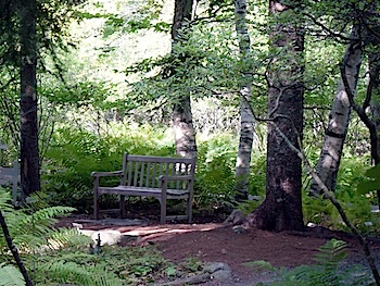
A quiet bench awaits you at the Wild Gardens of Acadia. NPS photo.
Pretty Marsh Picnic Area. This is the smallest picnicking area in the park, with just 11 tables and eight fireplaces. Located on the western shores of Mount Desert Island, the heavily wooded setting overlooks Pretty Marsh and offers water access if you have a kayak or canoe.
Wild Gardens of Acadia. Gardeners, botanists, and even birders love the Wild Gardens of Acadia. Though less than an acre, the landscape is lush with hundreds of plant species native to the park. The plants—Evening primrose, Trout Lily, Rosybells, Bog Orchids, Scullcaps and more—are labeled, too, for easy identification. The vibrant vegetation, and the tranquil stream, are a powerful lure for birds.
Park Loop Road in Winter. The closed sections are great for bicycling or walking if no ice covers the road, and the raw, wintry look of the park and the Atlantic are unforgettable. If snow does intrude, simply don some cross-country skis and skim along.
Wonderland. This overlooked stretch along the southern toe of Mount Desert Island features both forest running down almost to the water and rock aquariums—tidal pools that fascinate young and old.
National Mall and Memorial Parks
If anybody has the inside track on doing the Mall right, it’s the Trust for the National Mall's roving docents. Here are some of their insider suggestions:
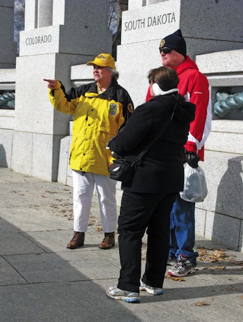
Docents on the National Mall are ready to point you to hidden treasures. Trust of the National Mall photo.
Bus A Tour: “We always recommend what we do in Europe,” says Roving Docent Steve Galloway. “Take a sightseeing bus tour. They’re a great way to see the city, get oriented, and know how to budget your time later, especially in the heat of July and August.” Focus: Unless you run by each of them you’re just not going to see five museums on the Mall in one day. Each museum deserves a half-day. (Or, research ahead and go directly to the art or artifacts you must see in each.)
Walk A Loop: The Mall is for walkers—and it is easy to craft a big loop walk past all the monuments you want to see. Connect the dots and go for it! Make It Metro: Parking can be a nightmare. Use the Metro to and from your hotel.
Some other suggestions from the Trust:
* Visit the memorial to the 56 Signers of the Declaration of Independence on the small island in the lake in Constitution Gardens. The Galloways, Mall Roving Docents, say people walk right by the gardens “without knowing what they’re looking at.”
* Visit the D.C. War Memorial (only monument to WWI on the Mall, and recently renovated.)
* Fishing in Constitution Gardens lake. Be sure to bring your own pole.
* A typo is visible in President Lincoln’s second inaugural address. While carving, the engraver accidentally chiseled an ‘E’ instead of an ‘F’ in the word “future.”
* Kilroy was here. The popular cartoon graffiti from WWII—a sign that American soldiers had come through—appears in two inconspicuous places at the World War II Memorial.
With 469 miles of pavement stretching from Shenandoah National Park to Great Smoky Mountains National Park, there are more than a few spots to enjoy in relative seclusion. If you long to see the spots where few other people pull off the Parkway, here are some hidden gems from the Blue Ridge Parkway Foundation.
Yankee Horse Ridge Parking Area: It’s an odd name for inspiring insight. Take this short path at Milepost 34.4 to Wigwam Falls but pause to ponder the railroad tracks in the woods—one of innumerable logging railroads that carried away the virgin timber.
Gwyn Memorial Trail: Pull off on the mysterious “US 221” exit at Milepost 298.6, then turn left into a parking slip for a 0.1-mile walk honoring Rufus Lenoir Gwyn, who helped choose the Parkway’s North Carolina route. You can’t even see this from the road. Great quiet picnic spot.
Take the “Old Parkway”: Before the Grandfather Mountain stretch of the Parkway was finished, motorists took a winding detour around the peak between Parkway Mileposts 298 and 305 on US 221, a North Carolina Scenic Byway. You can still do it. In fact, a circuit of US 221 and the now complete Parkway is a nice loop.
Orchard at Altapass: A lot of people sail by the Orchard at Altapass. But pull off the Parkway near Milepost 328 into a traditional family-owned heirloom apple business where live music and fun are a fall ritual. And, now there’s a TRACK Trail right on the premises.
Side Trip: Flashing south near Pisgah Inn, FSR 816 just looks like a gravel side road. Make the detour at Milepost 420.2 to the border of Shining Rock Wilderness and just 0.4 mile from the first trailhead the Art Loeb Trail tops out at 360-degree views from Black Balsam Knob.
Glacier's a big place, so you would think it'd be easy to flee the crowds, particularly when most stick to the Going-to-the-Sun Road. To enhance your odds, take these suggestions from the Glacier National Park Conservancy.
Visit the Two Medicine Area in the park’s southeastern corner. You can drive to Two Medicine Lake for a night or two at the campground, or hike up to Firebrand Pass or Cut Bank Pass.
The Belly River area in the park’s northeastern corner is often secluded as it doesn’t draw a lot of day traffic, instead luring mostly backpackers.
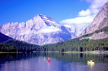
Take a scenic boat ride on Swiftcurrent Lake, or paddle yourself. Kurt Repanshek photo.
Day trippers like the views of 9,080-foot Chief Mountain, sacred to the Blackfoot Tribe.
Take a scenic boat ride on Lake McDonald, Swiftcurrent, Saint Mary, or Two Medicine lakes. Sit back, enjoy the scenery, and listen as naturalists provide a running narrative of the landscapes in front of you.
Enjoy Glacier like they did in the 1920s heyday of rail travel…on horseback! Swan River Outfitters is the official horse concessionaire in Glacier National Park that can take you on day trips to Cracker Lake and around Apgar, or up to Sperry Chalet for an overnight stay.
Want someone else to drive the Going-to-the-Sun Road so you can take pictures and learn more about the park? Take one of the variety of tours in the historic “Red Jammer” buses operated by Glacier Park, Inc.
This park is so huge, with the main attraction a ruddy gouge in the earth, that it would seem easy to find solitude. But the lure of peering over the rim can collect crowds. Take these suggestions from the Grand Canyon Association and you can avoid some of them.
Check out the ruins. Yes, ruins. Near Lipan Point on Desert View Drive on the South Rim you'll find the Tusayan Ruin and Museum. The ruins are little more than a stone outline of a 14-room structure that archaeologists say dates to the 12th century. But with a little imagination, and by reading the interpretive placards, you'll come away with some insights to the ancient cultures that lived here near the rim.
Become a hermit. Now, you might not escape the crowds by visiting Hermit's Rest on the west end of Desert View Drive (though you can minimize them by going early in the morning or evening), but you'll marvel at this rock shelter that dates to 1914 when it was built for park visitors to take a break on their hike down to Hermit Camp. Inside you'll find a fireplace and a small snack shop.
Cool off on the North Rim. True, the drive from the South Rim to the North Rim can take five hours (it's 215 miles), but the North Rim is about 1,000 feet higher than the South Rim, more heavily forested, and decided cooler in the middle of summer. You can, of course, shorten that travel time if you're a strong hiker by going down the South Kaibab Trail and then up the North Kaibab Trail, though making both hikes in one day is not recommended. In addition to enjoying the forests on the North Rim, take the time to travel out to Cape Royal, 23 miles from the Grand Canyon Lodge, for a spectacular view into the canyon.
Rise early. Set your alarm clock for an hour before sunrise, and then hike down to Cedar Ridge, about a mile-and-a-half below the South Rim. It's a gorgeous setting to catch the sunrise, and you're almost guaranteed to have the view entirely, or almost entirely, to yourself.
With 444 miles to explore, it would be understandable if you didn't find all the secret spots. That's where the folks at the Natchez Trace Compact come in handy with the following suggestions.
From majestic Indian mounds to authentic villages, the traditional homelands of the Natchez, Choctaw, Chickasaw and their ancestors, the Trace is abundant with Native American history awaiting your exploration.
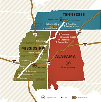
Along the 444 miles of the Natchez Trace Parkway, there are quite a few spots to explore.
Through the blaze of re-enactors muskets and history rich towns, the Trace and communities along its path preserve some of the most exciting Civil War history in America.
For Pulitzer-prize winning novelist Eudora Welty, the Natchez Trace inspired the dramatic tale of Robert Bridegroom, a handsome highwayman who disguised his hair with berry juice and stole his maiden as he galloped past on horseback, sweeping her off her feet in a heart-pounding ride to his lair.
While Welty’s story was a fairy tale, it should be noted that the romance of the Natchez Trace is not mere fiction, it is also historic fact. Along the Trace, love blooms as easily as the trees and wildflowers linking its route. Meander along this byway as your own love for the Trace blossoms.
Tread a portion, or all, of the 65 miles of Natchez Trace National Scenic Trail that runs along the Trace. This is a pathway perfect for foot traffic and horses. Along the way you might spot some of the nearly 160 bird species, enjoy, waterways, 12 state parks, and numerous golf courses adjacent to its path.
The Natchez Trace connects great Americans with great American culture, from W.C. Handy, “Father of the Blues,” Elvis Presley and Helen Keller to the Grand Old Opry, American arts and museums galore.
Leave your car at home and pedal your way through the scenery. The Parkway ranks as one of America’s Top 10 for cyclists, who benefit from five bicycle-only campgrounds along the route.
A big park, with the Grand Loop road network funneling visitors in circles, Yellowstone can pose some challenges. Consider the following suggestions from the Yellowstone Park Foundation for getting away from the pack.
Enjoy the wilderness setting of Imperial and Spray Geysers. A towering, wispy waterfall, one of Yellowstone National Park’s tallest, and two backcountry geysers via the same trail? That’s what you get when you leave the Fairy Falls Trailhead a little over 1 mile south of the turnoff to the Midway Geyser Basin. This hike can be done in as few as two hours and rewards you not only with that nearly 200-foot-tall waterfall, Fairy Falls, but with relative solitude (relative when compared to the park’s front-country geyser basins, that is) to enjoy Spray and Imperial geysers.
Enjoy the view from Observation Point. Often overlooked, perhaps because of its short distance or the many other opportunities in the Upper Geyser Basin, the Observation Point Trail offers a quick, relatively low-effort hike that rewards with a grand view of Old Faithful. It’s perfect for youngsters still developing their hiking legs. The trailhead lies just beyond the apron surrounding the Old Faithful Geyser.
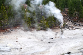
A seldom-visited spot in Yellowstone is the Monument Geyser Basin. Kurt Repanshek photo.
Trek to the Monument Geyser Basin. Most visitors to Yellowstone National Park are familiar with the Upper, Lower, and Midway geyser basins, but how many have made the trek to a basin that at one time, thanks to its oddly shaped spires and acidic hot springs, was another must-see attraction for park visitors?
Today the Monument Geyser Basin is largely overlooked, as the park’s other geyser basins lure most visitors with their readily accessible boardwalks, deep and colorful hot springs, curious mudpots, and erupting geysers. If you’re looking for a short, but strenuous, hike to a basin of spindly spires in a most unlikely spot, the trail to the Monument Geyser Basin waits for you.
Visit the junction of the Gibbon and Firehole rivers, which form the Madison, and ponder whether this was the spot where the idea of a “national park” was born in 1870 by early Yellowstone explorers. Today’s historians say that’s just myth, but the setting certainly is glorious.
Explore the Bechler. Located in the park’s southwestern corner, this is one of the least-visited areas of Yellowstone, in large part because you have to walk or ride a horse to visit. But the region, also known as “Cascade Corner” for its many waterfalls, is an excellent early fall destination if you enjoy hoisting a pack on your back and heading down a trail.
Story Categories:
A copy of National Parks Traveler's financial statements may be obtained by sending a stamped, self-addressed envelope to: National Parks Traveler, P.O. Box 980452, Park City, Utah 84098. National Parks Traveler was formed in the state of Utah for the purpose of informing and educating about national parks and protected areas.
Residents of the following states may obtain a copy of our financial and additional information as stated below:
- Florida: A COPY OF THE OFFICIAL REGISTRATION AND FINANCIAL INFORMATION FOR NATIONAL PARKS TRAVELER, (REGISTRATION NO. CH 51659), MAY BE OBTAINED FROM THE DIVISION OF CONSUMER SERVICES BY CALLING 800-435-7352 OR VISITING THEIR WEBSITE. REGISTRATION DOES NOT IMPLY ENDORSEMENT, APPROVAL, OR RECOMMENDATION BY THE STATE.
- Georgia: A full and fair description of the programs and financial statement summary of National Parks Traveler is available upon request at the office and phone number indicated above.
- Maryland: Documents and information submitted under the Maryland Solicitations Act are also available, for the cost of postage and copies, from the Secretary of State, State House, Annapolis, MD 21401 (410-974-5534).
- North Carolina: Financial information about this organization and a copy of its license are available from the State Solicitation Licensing Branch at 888-830-4989 or 919-807-2214. The license is not an endorsement by the State.
- Pennsylvania: The official registration and financial information of National Parks Traveler may be obtained from the Pennsylvania Department of State by calling 800-732-0999. Registration does not imply endorsement.
- Virginia: Financial statements are available from the Virginia Department of Agriculture and Consumer Services, 102 Governor Street, Richmond, Virginia 23219.
- Washington: National Parks Traveler is registered with Washington State’s Charities Program as required by law and additional information is available by calling 800-332-4483 or visiting www.sos.wa.gov/charities, or on file at Charities Division, Office of the Secretary of State, State of Washington, Olympia, WA 98504.
