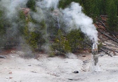
The Monument Geyser Basin is one of the oddest thermal areas you'll find in Yellowstone National Park. Kurt Repanshek photos.
Most visitors to Yellowstone National Park are familiar with the Upper, Lower, and Midway geyser basins, but how many these days have made the trek to a basin that once, thanks to its oddly shaped spires and acidic hot springs, was another must-see attraction for park visitors?
These days the Monument Geyser Basin is largely overlooked, as the park's other geyser basins with their readily accessible boardwalks, deep and colorful hot springs, curious mudpots, and erupting geysers pull most visitors. But if you're looking for a short, but strenuous, hike to a basin of spindly spires in a most unlikely spot, the trail to the Monument Geyser Basin waits for you.
The trailhead is located on the west side of the Grand Loop Road roughly 5 miles south of Norris Junction, or about 8.4 miles north of Madison Junction. There's a very small pullout just south of a bridge crossing the Gibbon River. From there, the trail runs a short distance north along a placid stretch of the Gibbon River before making a steep ascent to the geyser basin.
This area of the park was heavily burned during the 1988 wildfires. With each passing year, though, signs of that conflagration are slowly being erased by regrowth. As you head up the trail, which runs roughly 1 mile from trailhead to geyser basin, you pass through a narrow, green corridor of young lodgepole pines. Many of the pines range in height from about 15-18 feet, though some 20-footers stand out.
While the section along the river leads you to believe the hike is much easier than guidebooks make it out to be, within minutes of leaving the trailhead the path doglegs left and begins to climb steadily. In all, the gain in elevation is 500-650 feet (depending on which guidebook you believe).
There are several spots where you can catch your breath and enjoy expansive views north to Gibbon Meadows where the river carves lazy oxbows. Just before you arrive at the basin, a rocky outcrop provides sweeping views to the south into the canyon cut by the river.
You'll likely smell the sulphurous basin before you actually see or hear it. Once you come out of the trees, you see there are no erupting geysers, and no sparkling hot springs, but rather a collection of fuming sinter cones rising above a small, rolling saddle clasped on a ridge high above Gibbon Meadows.
According to the Haynes Guide Handbook of Yellowstone National Park written by Frank Haynes in 1910 (with numerous revisions down through the years), "One of the most striking features of this area is Monument Geyser, which erupts almost steadily 4 to 9 feet high. It is a spraying geyser having a cylindrical cone 6 or 8 feet high."
The basin was discovered in 1878 by P.W. Norris, according to an entry in Yellowstone Place Names by Lee Whittlesey. Mr. Whittlesey, the park historian, notes that the basin "was once a major tourist attraction with 12 monumental cones and features named "Sulphur Cone" and "Trip Hammer." In his 1883 guidebook, Henry R. Winser said one of sinter formations "resembles a crouching lioness; another, a headless man; a third, like a slender chimney, pours out a cloud of smoke; a fourth whistles like a locomotive; a fifth belches out steam with a whizzing sound which is quite deafening as you stand by, and is audible for miles."
Sadly, the basin these days is not as furious as it once was, and it would require a vivid imagination to see what Mr. Winser did. None of the basin's features spouts streams of boiling water. Rather, they fume and hiss and spout tendrils of smoke carried this way and that on the breezes. But the setting, so high above the valley floor and squeezed on the ridgeline, is unlike any other occupied by a geyser basin in Yellowstone.
According to the park's website, "this small geyser basin is one of the strangest spots in the park. Although the basin has no active geysers, its 'monuments' are made of siliceous sinter and appear very similar to the siliceous spires found on the floor of Yellowstone Lake. Scientists think that this basin’s structures formed from a hydrothermal system in a glacially dammed lake during the last stages of the Pinedale Glaciation."
If You Go
Monument Geyser Basin Trail
Trailhead Parking: Small pullout on west side of Grand Loop Road about 5 miles south of Norris Junction, 8.4 miles north of Madison Junction.
Length: About 2 miles roundtrip.
Difficulty: Moderate due to steep grade.
Payoff: The dying remains of one of the most curious geyser basins in Yellowstone. Nice views of Gibbon Meadows.
Map: National Geographic Trails Illustrated #303, Mammoth Hot Springs.
Story Categories:
A copy of National Parks Traveler's financial statements may be obtained by sending a stamped, self-addressed envelope to: National Parks Traveler, P.O. Box 980452, Park City, Utah 84098. National Parks Traveler was formed in the state of Utah for the purpose of informing and educating about national parks and protected areas.
Residents of the following states may obtain a copy of our financial and additional information as stated below:
- Florida: A COPY OF THE OFFICIAL REGISTRATION AND FINANCIAL INFORMATION FOR NATIONAL PARKS TRAVELER, (REGISTRATION NO. CH 51659), MAY BE OBTAINED FROM THE DIVISION OF CONSUMER SERVICES BY CALLING 800-435-7352 OR VISITING THEIR WEBSITE. REGISTRATION DOES NOT IMPLY ENDORSEMENT, APPROVAL, OR RECOMMENDATION BY THE STATE.
- Georgia: A full and fair description of the programs and financial statement summary of National Parks Traveler is available upon request at the office and phone number indicated above.
- Maryland: Documents and information submitted under the Maryland Solicitations Act are also available, for the cost of postage and copies, from the Secretary of State, State House, Annapolis, MD 21401 (410-974-5534).
- North Carolina: Financial information about this organization and a copy of its license are available from the State Solicitation Licensing Branch at 888-830-4989 or 919-807-2214. The license is not an endorsement by the State.
- Pennsylvania: The official registration and financial information of National Parks Traveler may be obtained from the Pennsylvania Department of State by calling 800-732-0999. Registration does not imply endorsement.
- Virginia: Financial statements are available from the Virginia Department of Agriculture and Consumer Services, 102 Governor Street, Richmond, Virginia 23219.
- Washington: National Parks Traveler is registered with Washington State’s Charities Program as required by law and additional information is available by calling 800-332-4483 or visiting www.sos.wa.gov/charities, or on file at Charities Division, Office of the Secretary of State, State of Washington, Olympia, WA 98504.

National parks and their natural resources belong to you. The National Parks Traveler works to ensure you know how these essential places are being cared for.
Sign Up For Our Weekly Newsletter
Unsubscribe at any time.
INN Member

The easiest way to explore RV-friendly National Park campgrounds.

Here’s the definitive guide to National Park System campgrounds where RVers can park their rigs.
Our app is packed with RVing- specific details on more than 250 campgrounds in more than 70 national parks.
You’ll also find stories about RVing in the parks, tips helpful if you’ve just recently become an RVer, and useful planning suggestions.
