Thigh-deep in the strong, bracing currents of the Bechler River was not exactly what I expected when I set out to explore Yellowstone National Park's Cascade Corner. But at least it was mid-September, and not mid-July, when the torrent surely would have been colder, deeper, and stronger.
If not for Stanley, a seasonal park ranger heading out of the Bechler region after days of backcountry maintenance revolving around the unenviable chore of relocating, if necessary, pit toilets, Bob and I might have been waist-deep. Stanley, who crossed the river from the dry position atop his steed, had told us to cross not where the horse ford obviously was, but just downstream on the other side of a spring pouring into the river.
"It's shallower," he told us.
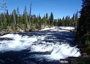
The beauty of hiking Cascade Corner in Yellowstone is easy to see. This section of the Bechler River is simply called "Cascades." Kurt Repanshek photo.
But not much. After stripping down to our skivvies, trading hiking boots for Crocs, and wading in to begin the 40-50 foot river crossing, we wondered how wonderful it would have been to be astride horses.
Fortunately, standing 6-foot tall kept the cold waters at bay for me, but Bob, somewhat shorter, endured, shall we say, a more exhilarating crossing.
Almost from the time I arrived in the West in the mid-1980s my eyes had been fixated on Cascade Corner in the southwestern quadrant of Yellowstone. Over the years Bob and I had paddled the park's three big lakes -- Lewis, Shoshone, and Yellowstone -- on wonderful multi-day excursions into the backcountry, and backpacked from Old Faithful down to Shoshone.
But the Bechler always eluded me. In part, because of the logistics. The soggy nature of the region runs into mid-summer, and the park won't issue backcountry campsite reservations before July 15 so sopping wet can Cascade Corner be. With two sons in high school until somewhat recently, fall trips were impossible to schedule.
Too, it's not the easiest part of Yellowstone to reach. You either need to hike down from Old Faithful, take a jouncing ride east from Ashton, Idaho, to the Cave Falls Trailhead, or come in from the east via one of the trailheads off the Grassy Lake Road.
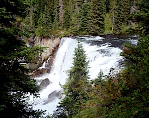
Iris Falls. Kurt Repanshek photo.
In looking at the trip's logistics, Bob and I, having hiked the Appalachian Trail in Shenandoah Park, kayaked into Muscongous Bay off the coast of Maine, and paddled Shoshone Lake in recent years, got ambitious. We would make a roughly 80-mile swing through Cascade Corner, looping from Old Faithful down into the Bechler, then up over the Pitchstone Plateau to Shoshone Lake, and back to Old Faithful.
It was an ambitious plan for seven days, one that in the end proved too ambitious.
With the soggy and bug seasons unappealing, we focused on mid-September, figuring there'd be little water concerns and no bugs to battle. We were somewhat right.
The night before departure was spent in a Frontier cabin at Old Faithful, a decidedly cozy, but also comfortable, room for two backpackers simply looking for a soft bed near the trailhead.
The heavy rain that night was somewhat foreboding, but gave way to mostly sunny skies the following morning. From the trailhead due west of the Old Faithful Clinic, the Howard Eaton Trail meanders roughly 3 miles through lodgepole forest, much of what is regrowth from the 1988 forest fires, to the Shoshone Lake Trail near the Lone Star Geyser.
From there you cross the Firehole River via a sturdy bridge, and slowly climb up to Grant's Pass, an 8,000-foot high point on the Continental Divide where the trail passes through a rocky outcrop. (It's named not for President Grant, who signed the legislation creating Yellowstone, but rather for M.G. Grant, a survey engineer for the Northern Pacific Railroad whose team was looking a railroad route through the park, writes Lee Whittlesey, Yellowstone's historian, in Yellowstone Place Names.)
From there it's all downhill. Kind of.
In general, the Bechler River Trail does indeed head downhill towards the southwestern corner of the park, draining everything along with it. But along the way there are some steep pitches to get you up and over ridges that rise above 8,500 feet.
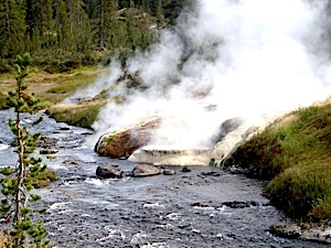
"Mister Bubbles," on the Ferris Fork, is popular with hot potters. Kurt Repanshek photo.
Our intended route was to follow the Bechler River Trail to its junction with the Mountain Ash Creek Trail, head east towards the Pitchstone Plateau Trail, then north past Lewis Lake to the southern shores of Shoshone Lake where we'd pick up the Shoshone Lake Trail and head back west to the Howard Eaton Trail and Old Faithful.
For someone seeking some peaceful time in the mountains, in a landscape many would not normally associate with Yellowstone, this is a great option for a week-long escape. September is a particularly fine month to tackle it, too, as the bugs are almost gone, the streams are manageable, and crowds don't exist. And there are waterfalls, spectacular waterfalls, with such names as Twister, Albright, Iris, Colonade and Union.
But if you're not comfortable crossing rivers with a pack on your back, this journey is not for you.
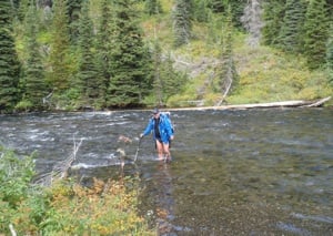
Having suvived the deepest section of the Bechler, Bob was home free. Kurt Repanshek photo.
One day we sloshed through the near-ankle-deep headwaters of Littles Fork near 8,554-foot Douglas Knob. Another we encountered four stream crossings, and all but one more than captured our attention.
The first was a narrow and shallow stretch where the Bechler River is still contemplating the prospect of becoming a river. It was perhaps 10 feet across and about knee deep. It was a somewhat good primer for what was to come, but it didn't devulge all the nuances of fording a major stream.
Those details came to light not far down the trail when we encountered a crossing where the Bechler was indeed a full-fledged river. While Stanley, who had quickly left us behind on that first crossing, had told us where to cross, and while there was an orange marker nailed to a tree to direct hikers, standing on the bank of the Bechler and looking 40-50 feet across did not immediately instill confidence. Had the ranger not passed on the tidbit of where to cross, we might never have seen that second orange marker (the first denotes the horse crossing) and tried to ford in what seemed to be the most obvious place and quickly run into trouble.
As it was, the current was swift, the water cold, and it certainly added to the backcountry experience. Once on the other bank, we quickly dried off, swapped Crocs for hiking boots, and headed on down the trail.
The landscape here is spectacular. Though the trail is rocky in places and at times weaves tightly through vegetation -- including raspberry bushes that in mid-September are heavy with ripe fruit, something that kept us watching for bears -- it follows the bends, bows, and cascades of the Bechler. You pass Cascades, Iris Falls, and then reach Colonade Falls, which requires a short detour to an overlook that, for those unfamiliar with this waterfall, offers a great view of not one, but two waterfalls!
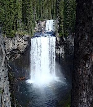
Colonade Falls alone is reason to visit the Bechler region. Kurt Repanshek photo.
One section of trail shows the determination of trail crews, as the path runs between a steep scree slope and the river.
When you reach the northern lip of Bechler Meadows, the landscape opens up, the trail flattens out, and you can cruise. Near the south end of the meadows, we veered east onto the Mountain Ash Creek Trail, which offered two more water crossings, neither of which was clearly marked on our Trails Illustrated Map (302).
The first involved an unnamed tributary that once-upon-a-time might have had a log-crossing for hikers, but that was long gone. A 5-inch log spanning the creek might have been used by some, but the prospect of falling into the deep creek convinced us to search a bit more. In the end we opted to simply wade in, again thigh-deep, and quickly move on.
The last ford came miles down the trail as we headed to our campsite, 9U4. With the afternoon fading, and the miles beginning to wear on us, we discovered a 30-40-foot crossing of Mountain Ash Creek, again with no obvious entry point other than for horses.
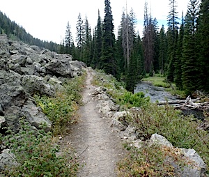
Trail crews put a lot of sweat into this section of the Bechler River Trail. Kurt Repanshek photo.
With daylight waning, we quickly crossed through water that once-again was thigh-deep, swift, and cold.
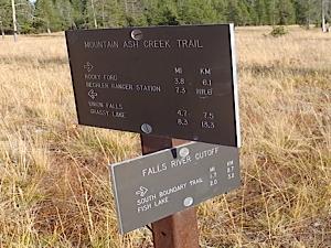
After two nights at 9U4 (which is next to Mountain Ash Creek, a gorgeous stream, and a 2.5-mile spur trail heading to Union Falls, the park's tallest) we headed on down Mountain Ash Creek Trail. Yet again we encountered another stream crossing made easier, mercifully, by downed logs. Then we began a steadly uphill that provided sweeping views of Birch Hills to the south and which, at times, climbed over limestone bedrock.
While we intended to turn north towards the Pitchstone Plateau and thus avoid a ford of the Falls River, what seemed like an innocent cough four days earlier was turning into pneumonia for Bob. Rather than pushing on 11 more miles, and roughly 1,000 feet in elevation, up onto the Pitchstone Plateau for our next campsite at 8,500 feet, we opted for prudence, forded the river, and hiked out to the Grassy Lake Road.
From there we were able to catch a ride to U.S. 89, hike to the park's South Entrance, and continue on back to Old Faithful. There the friendly staff at the medical clinic quickly diagnosed Bob's woes, delivered some antibiotics with a nice, big needle, and filled another prescription for oral antibiotics and cough medicine.
While we weren't able to complete our route, we did conquer the prime objective, which was to tour the Bechler region with its many waterworks.
If You Go
Trailhead: Howard Eaton Trail, Old Faithful (OK2 on the park's backcountry planner)
Length: Variable. You can carve out this roughly 80-mile trip that we had planned, or beeline it down to the Bechler Ranger Station. That covers roughly 30-35 miles. The problem with that, though, is lining up a vehicle shuttle.
Difficulty: While the hiking isn't too difficult, stream crossings can raise the difficulty level.
Payoff: Incredible waterfalls and, for those who like to soak, Mister Bubbles awaits.
Humble hints: While campsite 9B9 offers spectacular views of 260-foot Albright Falls, which cascades down a slope and practically falls on top of the site, the moisture in the air kicked up by the falls can create a condensation problem in your tent. If hot potting is key to your trek, a better site would be 9D1, which is much closer to Ferris Fork and Mister Bubbles. Definitely bring something such as Crocs or Tevas to wear for stream crossings, and hiking poles help you maintain your balance. Any mileage notations you find in trail guides or maps should be viewed as ballpark estimates. One 15-mile notation turned into an 18-mile hike. Also, the Bechler region is definitely horse country, and at times you can find yourself side-stepping quite a few deposits and sloshing through muddy sections where the horses' hooves churn things up.


 Support Essential Coverage of Essential Places


Comments
Most interesting, Kurt. Nicely written.
Sounds like a great hike, Kurt. It's been on my to-do list for a long time, awaiting a free September.
Do you know whether those are typical September river levels? Or did the heavy snowpack of 2010-11 make the rivers much fuller, much later than usual?
That's a great question, Bob, though one I can't exactly answer. I did ask Ranger Stanley if he thought it was wetter than usual (I think this was his third season in that area of the park), but he didn't think so. The big crossing of the Bechler definitely caught our attention, as did that of Mountain Ash Creek...
It's been so long since I've been in an Alpine environment! It's been all Grand Canyon for the last five years and with your article, Kurt, I'm hearing the call but don't think I'll ever be through with the Canyon! Will have to make some forays. Thanks, Kurt.
As a local who hikes this area yearly i can attest to the water crossings being more difficult than one would think. We were the first group allowed all the way through in 2011 in mid august. and only because i begged and pleaded with the ranger to let us go. (it was my bachelor party) there was still alot of snow over douglas knob. The streams were running much higher than usual. Mr bubbly was really cold still. There are so many hidden waterfalls off the trail it would take a lifetime to find them all. Glad you were able to enjoy the cascade corner. come on back and stay awhile!
I live in Victor. This hike sounds amazing and I would like to explore this area. What trail head would you recommend for a good day hike, or good 3-4 day trip? From just googling the area, the Ashton/Cave falls sounds like a reasonable place to start. Any pointers would help greatly!
Thanks
Dylan
Dylan, you're right, the Ashton/Cave Falls area would be your nearest entry point. From there you can piece together some nice treks, either out-and-back up towards Mr. Bubbles or up towards Dunanda Falls, or a loop of sorts that involves the Cave Falls Trail, the Mountain Ash Creek Trail an the Union Falls Trail. Late summer's the time to go. Just be prepared to ford some streams.
I have done the Bechler 3 years in a row now, always in late Sept or early Oct. This past year, 2011, was the first time I almost lost it crossing the river. Managed to stay upright but had to crouch down so much keeping my balance that I basically was chest deep. Talking to the Rangers about crossing points is the best way to figure out where.
One year we were a group of eight so we began at opposite ends of the trail, met at Three Rivers Meadow , exchanged car keys and then completed the hike one way.
Last year we , just two of us, started at the Bechler Ranger Station and made a loop going east to Union Falls, then backtracked along the Mountain Ash Creek trail and went northwests to the Bechler, then turned around at Three Rivers and back out through the Bechler Meadows. Five nights, longest day was 15 miles, because we made a side trip to Union Falls and doubled back.
I prefer the section of the trail on the southern end and this year will probably go to Dunanda falls and explore that area.