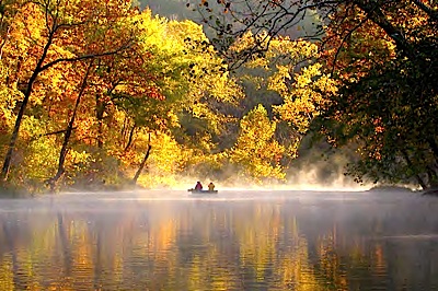
While idyllic in many areas, the Ozark National Scenic Riverways in Missouri is not without its threats. Photo by Wayne Goode.
Editor's note: Earlier this year Ozark National Scenic National Riverways was named to American River's list of Most Endangered Rivers. Park officials contested that dubious listing, questioning the number of trails open to horse travel cited by American Rivers, as well as that group's concerns over rampant off-road vehicle use in the riverways. In the following two-part article Susan Flader, who long taught in the University of Missouri-Columbia History Department, traces the riverways' history while pointing to many of the problems it faces. The article originally appeared in The George Wright Forum, the journal of the George Wright Society, and we publish it here with their permission.
Missouri’s Current River and its tributary, the Jacks Fork, were the nation’s first federally protected rivers. Congressionally authorized in 1964 as the Ozark National Scenic Riverways, they served as a prototype for the National Wild and Scenic Rivers Act of 1968. But in May 2011, ONSR was identified by American Rivers as one of America’s ten most endangered rivers, owing to a history of inadequate management by the National Park Service.
The spring-fed, bluff-lined Current and Jacks Fork are the preeminent “float streams” in a state where floating, fishing, and camping by johnboat or canoe have long been favorite pastimes. The state’s first Republican governor since Reconstruction, Herbert Hadley, led well-publicized float trips on Current River as early as 1909 in an effort to promote tourism and build support for a state park system.
When Missouri acquired its first state parks in 1924, they included Round Spring and Big Spring on the Current River and Alley Spring on the Jacks Fork. The rivers early attracted admirers from afar; Aldo Leopold came from Wisconsin in 1926 to float the Current from Van Buren to Doniphan with his brothers, then in 1929 bought a shanty on its bank as a base for annual hunts, years before he acquired his celebrated shack in the sand country of Wisconsin.
Like many other rivers that eventually won designation as national wild and scenic rivers, the Current was threatened by proposed hydroelectric dams. While the notion of a riverine park had been advanced by a local hunting and fishing club as early as the 1920s, even before authorization of two dams on the Current in the 1930s, a recommendation that the river remain free-flowing and developed for recreation, as advocated by local groups and state officials, emerged from the Arkansas–White–Red River Basins Interagency Committee in 1954 and resulted in two NPS-led studies later that decade.
The first study proposed designation of about two-thirds of the watersheds of the Current, Jacks Fork, and Eleven Point rivers as a national recreation area, with special emphasis on preservation of the streams and springs; the second, after the U.S. Forest Service objected to the incorporation of 350,000 acres of national forest in the NPS-led project, proposed NPS acquisition of 113,000 acres of river corridor as a national monument, most of it preserved in wilderness-like settings with minimal development.
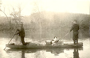
Aldo Leopold and his brother Carl pole a johnboat on a 1926 float and hunt trip on Current
River south of Doniphan. Photo courtesy of Aldo Leopold Foundation.
Two types of bills—one providing for administration of the rivers by USFS, the other by NPS—were introduced in Congress beginning in 1960.
The USFS advocates, including conservationist Leo Drey of St. Louis, who owned some 130,000 acres of forest with 35 miles of frontage on the Current and Jacks Fork, argued that the USFS was already known and relatively accepted by Ozarkers and had ample land on which small recreational impoundments could be developed, thus helping to disperse recreational pressure and better preserve the three rivers; they favored continued multiple use of the watersheds and the use of scenic easements to protect the rivers without unduly infringing on private property.
Advocates for NPS management were led by newspaper columnist Leonard Hall, who had just published Stars Upstream (1958) arguing for protection of the Current as a national river, and George Hartzog, who as superintendent of the Jefferson National Expansion Memorial in St. Louis had been appointed NPS lead in promoting the new area.
But when Interior Secretary Stewart Udall floated the Current in 1961 with Hartzog and Hall, and President Kennedy subsequently endorsed the plan for an Ozark National Monument, the die was cast in favor of the National Park Service. As another consequence, Hartzog would be appointed by Udall as NPS director in 1964, and ONSR would be his first new park.
As part of the deal that led to congressional approval of Ozark National Scenic Riverways in 1964, the lower Current, with better agricultural land along its banks, and the Eleven Point, which flowed largely through national forest, were dropped from the bill; the state agreed to transfer to NPS its three big-spring parks on the Current and Jacks Fork as focal points of the new ONSR; and NPS agreed to allow hunting in the park and the use of scenic easements as well as eminent domain to protect the river corridor.
The Eleven Point, in turn, would become one of the initial rivers designated in the National Wild and Scenic Rivers Act of 1968, under USFS management. ONSR included 134 river miles with two gaps at the towns of Van Buren on the Current and Eminence on the Jacks Fork. Its watershed boasted a world-class spring system unparalleled in North America, with 350 springs, many of them located near the rivers (including the largest spring to date in the national park system), and more than 330 caves.
As scientists undertook more intensive ecological surveys, they would begin to appreciate that the Current River watershed is an international center for biodiversity, with more than 200 endemic species. As of 2010, the area included two federally listed endangered species (gray and Indiana bats), another proposed for listing (the iconic Ozark hellbender salamander), and 70 state-listed rare or endangered plant and animal species. The riverways also abounds with archaeological sites, historic structures, and landscapes reflecting 12,000 years of human habitation.
But except for the three state parks, which were transferred to NPS in 1970, most of the land within the authorized boundaries of the narrow riverine park was private, and would have to be acquired in fee simple or protected from development and timber-cutting by scenic easement. Because NPS insisted on the right of public access 300 feet back from the river on scenic easements, many fiercely independent Ozark farmers, who disliked any kind of government control, felt forced to sell.
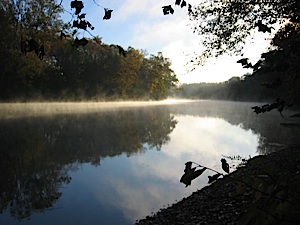
Dusk draws near on the Current River. Photo by Elizabeth Meyer for NPS.
But Congress authorized only $7 million in the 1964 act to acquire up to 65,000 acres of private land, leading NPS officials to set upper limits on appraisals, which meant that more than 200 cases ended up in court.
Although the courts tended to set considerably higher values than initially offered by NPS, the forced sales and contentious proceedings led to a heritage of ill will toward NPS by many in the region.
Meanwhile, the more urban owners of riverside cabins, who had been expected to sell with life tenancy, instead were offered and opted for easements with essentially perpetual tenancy. Because ONSR was the first such park, NPS officials were necessarily learning on the job; until Cape Cod National Seashore (1961), most previous national parks had been acquired by transfer of other public lands or donated private land.
Moreover, Hartzog’s dynamic tenure as director, coinciding with the new Land and Water Conservation Fund (1964), led to the rapid acquisition of 70 new national parks, so there was a shortage of experienced administrators.
Meanwhile, the public flocked to the newly designated riverways before NPS was ready. Local outfitters and others who had operated small businesses along the rivers for decades bought more canoes to satisfy the demand and exercised disproportionate influence on local NPS officials.
Canoeists, who reached an estimated 40,000 in 1968, climbed to 145,000 in 1973 and nearly 300,000 by 1979, out of total visitation of nearly 2 million. Moreover, canoeists and other visitors were concentrated in certain stretches and on summer weekends. Though NPS sought some control in 1970 by licensing 16 canoe outfitters, dozens of others operated without permits, launching canoes just upstream of the park boundary. An unfavorable court decision in 1976 stifled NPS efforts at control, though subsequent decisions in the early 1980s were more favorable.
Controversies over efforts at control, coupled with a rapid turnover of superintendents in the early years, stymied the development of a general management plan for the park. While USFS completed a plan for the Eleven Point by 1973 and the Buffalo National River in Arkansas, designated in 1972, had a plan by 1977, an initial draft prepared for ONSR was rejected by Washington NPS officials in 1976 and a new draft was not prepared until 1981, finally winning approval in 1984.
Two decades after Congressional designation, ONSR officials finally had a general outline for management, but it was a plan that called for more studies to support more specific plans on a host of issues that had already been festering for decades. The 1984 GMP, which is still in effect today, reaffirmed NPS commitment to preservation of natural and cultural resources and the scenic and ecosystem integrity of the riparian corridor, and called for studies to determine levels of use that certain areas could experience without resource degradation. It affirmed the early policy of developing visitor service areas with river access, campgrounds, and other facilities at sites within a day’s float from each other—initially 13 such sites, now 19.
The plan also acknowledged the existence of some 40 de facto camping and river access sites generally accessible by unimproved county roads and provided for a more detailed study of them and of other roads, traces, and horse trails in the riparian corridor. Deleted from the final plan owing to ongoing litigation were any proposals regarding management of river uses, but after NPS authority to regulate canoes was affirmed the park issued a draft river management plan.
Canoe rental had greatly outpaced the increase in other river uses until 1979, when it leveled off at about 300,000 visitor-days per year, suggesting that it had reached carrying capacity (with 61 percent of respondents perceiving crowding). But after a court decision allowed park officials to begin controlling rental numbers and put-in locations in 1984, perceptions of overcrowding declined to 38 percent.
Meanwhile, motorboating increased from 3,600 boat-days in 1974 to 12,000 in 1980 with the introduction of jetboats, which could be operated with less knowledge of specific river conditions. While most canoeists were non-local, motorboaters were mostly local and concentrated in the lower river around Van Buren, the park headquarters, where they could more easily influence park officials.
Motorboating was the most controversial issue in the plan, with many jetboaters not wanting any regulation and many canoeists (and, presumably, tubers) asking for complete elimination. The plan proposed zones with motors of no greater than 25 horsepower (hp) in the upper reaches (10 hp at peak times), 40 hp in the middle, and no limits below Big Spring (or in the gaps), to take effect in 1993 (on the Buffalo River the limit is 10 hp, on the Eleven Point 25 hp). River access and camping issues were deferred to the roads and trails study, for which NPS commissioned two field studies in 1986. One compiled an inventory of 352 roads and traces with a total distance of 318 miles within ONSR boundaries, of which 93 (including the official developed areas) provided river access.
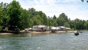
Campsites often pop up low on the river's beaches. Photo by Susan Flader.
The other study identified a total of 62 riverbank “primitive areas” (up from 40 estimated in the GMP), most of them accessible by land vehicle, and reported that these sites, on average, had lost 58 percent of their ground cover and had four trees damaged.
How many of these roads and campsites already existed in 1964 has not been determined. The field inventories provided data for a roads and trails study, issued in 1991, in which park officials sought to develop a protocol for closing problematic roads and vehicular access to primitive camps. They excluded from consideration any county roads, undoubtedly to avoid confrontation with county officials.
More inexplicably, they elected not to close other roads that led to primitive sites, despite numerous visitor comments and letters decrying the “visual intrusions of large numbers of vehicles along the riverways.”
In the end NPS proposed closing only 54 non-county road segments that jeopardized threatened or endangered species, showed resource damage or safety hazards, or provided redundant access. The road closure alternatives included a short (less than 4-page!) environmental assessment, in which the socioenvironmental impacts considered solely the adverse impacts of closures on those who used the roads to access primitive areas, not the impacts on the far larger numbers of visitors who floated the rivers and objected to the intrusion of motor vehicles on riverbanks and gravel bars.
It should be noted that the camping areas developed by NPS are all set back and screened from view from the river, while in the unofficial primitive sites anything goes, including slashing and mowing vegetation and reshaping banks to open the view and improve access to the river. Moreover, the roads to them are not shown on any ONSR maps for general visitor use, meaning they are available only to those—mostly local residents—who have heavy duty vehicles or all-terrain vehicles (ATVs) and can find their own way there on a maze of unmarked, often deeply rutted roads.
Local Ozark families have been visiting the river for generations, and they want to be in their own spot, right on the river, not in a developed campground with others. The 1991 study also reviewed horse trails. Though it briefly mentioned the need for an inventory of trails throughout the park and for measures to relocate trails out of floodplains, reduce river crossings, provide switchbacks on steep slopes, and prevent trampling and tree damage by horses, its discussion of management alternatives considered only officially designated trails.
There were 14 miles of such trails at the time, all near the junction of the Jacks Fork and Current, where a commercial firm, located along the Jacks Fork on private land in the Eminence gap, offered stalls, camping and entertainment that attracted up to 2,500 riders and horses at a time. The study also noted that “horse use is permitted on all unpaved roads and traces within the park except where posted.”
Tomorrow: Trouble in paradise? The scenic riverways struggles as visitation drops and degradation grows.
Story Categories:
A copy of National Parks Traveler's financial statements may be obtained by sending a stamped, self-addressed envelope to: National Parks Traveler, P.O. Box 980452, Park City, Utah 84098. National Parks Traveler was formed in the state of Utah for the purpose of informing and educating about national parks and protected areas.
Residents of the following states may obtain a copy of our financial and additional information as stated below:
- Florida: A COPY OF THE OFFICIAL REGISTRATION AND FINANCIAL INFORMATION FOR NATIONAL PARKS TRAVELER, (REGISTRATION NO. CH 51659), MAY BE OBTAINED FROM THE DIVISION OF CONSUMER SERVICES BY CALLING 800-435-7352 OR VISITING THEIR WEBSITE. REGISTRATION DOES NOT IMPLY ENDORSEMENT, APPROVAL, OR RECOMMENDATION BY THE STATE.
- Georgia: A full and fair description of the programs and financial statement summary of National Parks Traveler is available upon request at the office and phone number indicated above.
- Maryland: Documents and information submitted under the Maryland Solicitations Act are also available, for the cost of postage and copies, from the Secretary of State, State House, Annapolis, MD 21401 (410-974-5534).
- North Carolina: Financial information about this organization and a copy of its license are available from the State Solicitation Licensing Branch at 888-830-4989 or 919-807-2214. The license is not an endorsement by the State.
- Pennsylvania: The official registration and financial information of National Parks Traveler may be obtained from the Pennsylvania Department of State by calling 800-732-0999. Registration does not imply endorsement.
- Virginia: Financial statements are available from the Virginia Department of Agriculture and Consumer Services, 102 Governor Street, Richmond, Virginia 23219.
- Washington: National Parks Traveler is registered with Washington State’s Charities Program as required by law and additional information is available by calling 800-332-4483 or visiting www.sos.wa.gov/charities, or on file at Charities Division, Office of the Secretary of State, State of Washington, Olympia, WA 98504.

Comments
We have been coming to the Summits for the past 15 years. Our four kids have grown up with friends they see every year - it been great! It is especially gratifying to bring extended family or see new summiteers experience it for the first time. Young and not-so-young enjoy the friendships and shared activities.
This highlights the
preservation problems related to the streams, wilderness, and wild caves
of Missouri, our wonderful environmental heritage. How do we education the vast public to the need for preservation of these natural areas because once they are worn out, they are gone?