
Editor's note: That threatened species are occupying beachfront popular with visitors to Cape Hatteras National Seashore has created a divide along the seashore and in its communities. In this, the final part of our series, the various viewpoints are laid out.
There Are Numbers and There Are Statistics
Though Park Service reports attribute the rise in plover nests and successful fledging rates to the interim ORV restrictions and better monitoring, the boost in turtle nests some say could simply be a normal cycling of reproducing females.
While groups such as North Carolina Audubon point to last year's record numbers of nests as proof that better control over where and when off-road vehicles can drive on the seashore's beaches contributes to nesting success, some ORV enthusiasts and those greatly concerned over beach access label such comments "propaganda" and "misleading," and lament that their tax dollars are, in effect, funding closures to protect both nesting sea turtles and threatened shorebirds, closures that deny them access to those same beaches.
Female loggerhead turtles are thought to reach sexual maturity when they're about 35 years old, making one wonder whether there was a population boom in 1975 that was finally realized, reproductively, last year. Or the high nest count could have been tied to a very good foraging year for female turtles to put on fat reserves to help them with their migration.
"It's classic to see fluctuations from year to year," Dr. Matthew Godfrey, the sea turtle program coordinator for the North Carolina Wildlife Resources Commission, told the Traveler last fall. "And it could be quite startling sometimes, especially with green turtles, but loggerheads you see it too. So it's not surprising to see a big change from year to year."
And yet, while there was a big change in nests at Cape Hatteras in 2010, Dr. Godfrey said that, overall, loggerhead nesting in the Southeastern states of North and South Carolina, and Georgia was good but not record-setting.
Seashore officials, however, have noted that the interim regulations have better controlled night driving on beaches that could adversely affect nesting turtles. Those regulations, however, apparently did not prevent someone from running over and killing a female loggerhead that came ashore near Ocracoke in June 2010 to lay her eggs.
While an off-road-vehicle group offered a $1,000 reward for information leading to the arrest and conviction of those responsible for running over and killing the turtle, so far no arrests have been made. Though some have accused the Park Service of covering up for one of its own that might have run over the turtle, seashore Superintendent Mike Murray has said they did not have patrols out on the beach the night the incident occurred.
Numbers also can be controversial when it comes to how much of the national seashore's 68-mile beachfront will be open under the approved ORV management plan.
Under the plan, new parking areas will be built along Highway 12 as well as new access ramps to the beach, and a new trail will allow pedestrians to walk down through the dunes to the beach. It also calls for a "seasonal night-driving restriction ... established from 9 p.m. to 7 a.m. during turtle nesting season, although areas with no turtle nests could open to night driving from September 16 through November 15." Additionally, it calls for an "alternative transportation study and would encourage the establishment of a beach shuttle or water taxi."
Overall, the approved plan will allow for 27.9 miles of year-round designated ORV routes on the seashore, 12.7 miles of seasonal routes, and 26.4 miles of vehicle-free miles.
The Surfcasters
Having deflated the tires of his Suburban so each held only about 20 pounds of pressure, John Couch drives me out onto the seashore under a bright June sun. The ocean is rhythmically slapping the beach, the air is warm, not yet too humid. Heading across Ramp 43 and out onto the sand, we’re greeting by roped off shorebird areas to our right, and, as we drive north, smaller rectangular exclosures protecting sea turtle nests.
In a matter of minutes we have to stop at a barrier that prevents further travel in this direction.Off in the distance rises Cape Hatteras Light.
As we sit in his rig talking fishing, turtles, and birds, Mr. Couch, the burly president of the Outer Banks Preservation Association, tells me in no uncertain terms that the 1,000-meter ORV boundaries set up around plover nests with chicks -- roughly equal to three football fields laid end-to-end -- are simply too much.
A Hatteras Island resident since 1965 who has grown barrel-chested and seen the passage of years drift grey into the hair of his head and face, Mr. Couch doesn't need long to search for words when talking about the buffers.
"What doesn't work is that amount of protection," says the 59-year-old, whose organization has been pushing back -- hard at times -- against the Park Service and its buffer zones. "One-thousand meters, that right there is a jobs killer. That right there is an access killer."
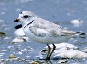 Piping plovers that nest on Cape Hatteras gain lots of protection. USGS photo.
On Cape Hatteras, there are 17 "ramps" -- beach access points for vehicles and pedestrians alike -- that have been developed over the years. Keeping them open can be difficult at times due to storms...and due to nesting habits of plovers, American oystercatchers, and least terns.
While loggerhead turtle nests can also lead to ORV and pedestrian buffers, these are usually only 30 feet by 30 feet.
Ramps 43 and 44, which provide access to Cape Point, are not the only areas where beach-goers on foot and in truck encounter barriers. But they are among the most controversial as the fishing from the lip of Cape Point is arguable the best on the seashore. Elsewhere in late June and continuing into July I found that Ramps 27 and 30 between Salvo and Avon were closed due to nesting American oystercatchers and least terns, and there are other examples, as well.
"Not only is it closed to ORV access," Mr. Couch points out in discussing the closures as we ride the beach, "but it's closed to pedestrians and it's closed for miles. That's a major difficulty for everybody.”
"Everybody," he continues, are those who like to drive on the beach and those who like to walk. "I'm trying to group it together, because we're all in it together."
Improving additional habitat for the birds, he suggests, could be a solution to the acrimony. Use a bulldozer to scrape away some of the vegetation that has rooted in the dunes near Cape Point, and let the waves wash over it and create the habitat plovers seek, he suggests.
"What we're saying is why can't we have a partnership with the environmentalists? We can improve this habitat," said Mr. Couch. "They (the Park Service) have yet to do anything to improve the habitat for the birds.”
A few doors down from Mr. Couch's autoparts store, Bob Eakes makes his living fishing as the owner of the Red Drum Tackle Shop. The seashore restrictions, he said, have cut deeply into his business by placing Cape Point out-of-bounds beginning in the spring and running deep into summer.
"My business in March of this year was 70 percent off of what it was five years ago," Mr. Eakes said, adding that he's had to cut his staff in half, to just five employees.
While it's said that fishing on the national seashore is best in the fall, the tackle shop owner said that's not entirely true.
"Fishing's fishing. The spring drum run has been every bit as good as sometimes as it is in the fall," said Mr. Eakes. "We had a flounder bite this spring that was the best I've seen in 20 years. The guys were having to park, walk almost a mile to get to the point, they're catching their limit of six flounder in 15-20 minutes, and coming back with them.
"And so those that are physically able to walk out there, that's sorta OK, but most people can't take a mile walk in soft sand."
While week-long vacationers seem to be shifting their visits to Cape Hatteras until later in the summer and September, "which is sort of pretty good," he said, "it still doesn't make up for the loss of the weekend crowd, and they just don't come. The guys who used to come down here to drum fish on Cape Point and down at the inlets, they'd come for long weekends, they just do not come back."
The bottom line, Mr. Eakes tells me, is that the Park Service is determined to turn the national seashore into a wildlife preserve where humans aren't welcome.
"It's no longer about the resource. It is about banning people from this federal park," he maintained. "That's what's going on, that's what they're doing. There are 11 other federal seashores and parks whose plans have been put on hold to see if they can get away with giving endangered-species protections to non-endangered species.
"And if you're comfortable with it, then welcome to a park that's going to open 9-5, they're going to charge you eight bucks to climb to the top of the lighthouse and have a heart attack, and let you come back down. And when you get down, guess what? 'Hit the road, buddy, we don't want you no more.' That's where they're taking this to."
The Conservationists
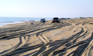 Beach driving can leave lots of ruts for pedestrians to negotiate.
Drawing just as much, if not more, animosity from the ORV backers than the Park Service are conservationists, both those who actively brought the lawsuit that forced the issue and those who believe the threatened species should be aided by beach closures if necessary.
Some of those targeted tell of nails being spread across their driveways, being denied service in businesses, and even being verbally threatened.
Derb Carter, director of the Southern Environmental Law Center that brought Audubon's and Defenders' lawsuit against the Park Service, is despised by many beach drivers, but at times doesn't sound too different from Mr. Couch in why this issue hasn't been resolved.
"I thought this thing was pretty easily solvable, but apparently not," says Mr. Carter, who back in 2005 was voted North Carolina's "Conservationist of the Year" by that state's Wildlife Federation.
When the seashore's ORV management plan takes effect in 2012, Mr. Carter believes "it will be a significant improvement over the way things have been managed. "Whether they can sustain that at a necessary level will be a challenge," he continues.
Jim Lyons was not a party to the lawsuit, nor a was he involved in fashioning the consent decree that has guided ORV management on the seashore these past three years. But as a local he has witnessed the fray up close.
A school teacher for 30 years on Hatteras Island, he has over the years enjoyed, and continues to enjoy, the fishing and duck hunting the national seashore provides. He had his students study life cycles using the mosquitoes so often found in summer, and required them to prepare field guides of the small fish they would catch in Pamilico Sound. Too, they’ve dissected snow geese Mr. Lyons would shoot before school, bring to class for dissection, and then pass on the meat to the cafeteria to fix for lunch.
He’s been on Hatteras a long time, is familiar with its recent human and recreational evolution, and, as with Mr. Couch, has some thoughts on the past and current states of access.
“We would walk for two hours and never see a track, never see a car,” Mr. Lyons recalled of his first few years on the island some 50 years ago.
Before long, though, that began to change.
“My friends and I would pull over on the side of the road in the late ‘60s and early ‘70s and walk over to the beach and see little sign of people or cars, but use patterns were really starting to change by then.”
While the ramps were put in by the seashore to provide access for commercial fishermen, as the park’s administrative record notes, as the years went by more and more folks began to use them to reach the beaches for fishing or other forms of recreation. “I think it just crept up on them,” Mr. Lyons said of the Park Service and the resulting traffic the years brought.
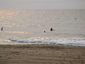 Surfers found their way to the beach in June despite closures elsewhere on the national seashore. Kurt Repanshek photo.
His wife, Marcia Lyons, was a Park Service biologist for years. When she first arrived at the national seashore in the 1970s, she tells me, “so many people walked out to the (Cape) point. People walked with their fishing poles.”
While those who argue that ORV access to the beaches long has been a tradition on the Outer Banks, reading past accounts of how the national seashore evolved indicates that ORV beach use never was intended to grow into what it’s become today, when holiday weekends can bring hundreds of vehicles out onto the beaches.
"The legislation creating Cape Hatteras National Seashore did not specifically mention motor-vehicle use or beach-driving, and historical records from the park's establishment and early years do not indicate significant local concerns about preserving the right to drive vehicles on the beach,” notes Creation and Establishment of Cape Hatteras National Seashore.
“Quite the opposite ... local residents and state officials sought NPS support for roads, ferries, and bridges to avoid using beaches as roadways, and in return for their support of the park, local residents demanded NPS agreement to allow commercial fishing and hunting. The law did, however, clearly specify NPS authority to regulate the beaches for uses consistent with the purposes for which the park was established."
Caught in the Middle
"I totally understand and appreciate why people want to be there," Superintendent Murray replies when asked about the controversy over Cape Point, specifically, and the seashore's beaches, in general. "It's not like we're getting any pleasure out of closing things."
 Closure signs have not made the Park Service a popular agency with all on Cape Hatteras. Kurt Repanshek photo.
Whether any of his colleagues in the Park Service envied Mr. Murray when he was promoted to superintendent of the Outer Banks Group, a collection of Park Service units that includes the national seashore, the Wright Brothers National Memorial, and Fort Raleigh National Historic site, is certainly debatable in hindsight. After stints in Everglades, Yosemite, New River Gorge National River, Sequoia-Kings Canyon, Yellowstone, Yosemite, and Cape Cod National Seashore, where he was deputy superintendent for eight years and which had its own issue with piping plovers, Mike Murray walked into a powder keg on Cape Hatteras.
Somewhat complicating matters was that his arrival came after a housecleaning for the Park Service: the seashore's previous management -- its superintendent, its chief of resource management, wildlife biologist, even the Hatteras district ranger -- had been reassigned due to the increasingly rancorous debate over beach driving.
"We've kind of had to build a program from scratch with a great loss of institutional knowledge," the superintendent told me as we sat in the seashore's Buxton office discussing the prickly task before him.
In recent years Superintendent Murray and his staff have worked to regain that knowledge. Monitoring plovers during their breeding season has given the seashore a growing library of GIS (geographic information system) data to track the birds' movements, he explained.
Chicks are mobile on the first day out of their shells, and parents are on the move from nests to foraging habitat closer to water's edge.
"They regularly will move more than 200 meters" and up to 1,200 meters, Superintendent Murray says. "We're seeing that, so based on what we're seeing now, it would be imprudent to do a 200-meter buffer."
Access is a precious thing on the national seashore. After all, the seashore's calling card is a sandy oceanfront that lures surfers, shell collectors, beach strollers, and, of course, surfcasters. Until this summer it had been a few decades since I last visited Cape Hatteras, and that trip was for the fishing. Since then, the atmosphere -- figuratively, not literally -- has turned sour in places over birds, turtles, and beach driving.
A number of colorful towns -- colorful in name (Ocracoke, Nags Heg, Kill Devil Hills, Frisco, Kitty Hawk) and in the pastel hues brushed onto condominiums and townhouses that fill in summer with vacationers -- dot Cape Hatteras.
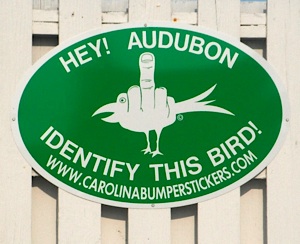 Apparently not all tourists are welcome at Cape Hatteras.
Yet the focal point of the outrage over the Park Service’s efforts to manage ORVs seems to fume most from Buxton and Frisco, two blue-collar Hatteras Island communities closest to Cape Point.
In these towns Park Service employees have been refused service in some businesses; it's been said that Superintendent Murray was threatened in one public meeting over birds, turtles, and trucks; and a gateway sign to Frisco depicts a middle-finger salute asking Audubon Society members to "Identify this bird."
That last attack is particularly curious in that it presents a decidedly hostile attitude that might affront not just Audubon members, but others considering a Cape Hatteras vacation.
The issue has had a great impact on running the national seashore, where 35-40 percent of Superintendent Murray's budget is devoted entirely to ORV management, and the biggest law-enforcement challenge is enforcing ORV regulations.
Whether there’s been any economic fallout on the seashore’s communities depends on whom you ask.
Official statistics note that Dare County (which encompasses Buxton, Frisco and Hatteras as well as Kill Devil Hills, Kitty Hawk and Nags Head ) counted $777.41 million in tourism spending in 2008, an increase of 1.9 percent from 2007. July 2008 saw vacation rentals along Cape Hatteras at a record high, as the motels, hotels, B&Bs, and campgrounds took in $101.7 million, a 16 percent increase over July 2009 revenues, according to the Dare County Visitor’s Bureau.
The economic numbers remained bullish into 2010, when Dare County visitor occupancy for the first eight months of the year was record-setting. Hatteras Island tourism income reached $27.8 million for lodging alone in July 2010, an 18.5 percent increase from July 2009 and also a record.
But some in Buxton and Frisco, such as Mr. Couch and Mr. Eakes, say the economic winds have blown dry on their communities, with the windfalls directed farther north at Nags Head, Kill Devil hills, and Kitty Hawk.
All, they believe, because the seasonal buffers intended to protect birds and turtles are keeping fishermen and women away.
Influencing the Park Service's decision to go with a 1000-meter ORV buffer once chicks are hatched were various studies that reported on chick movements. One, the U.S. Fish and Wildlife Service Revised Recovery Plan for Plovers, published in 1995, noted that one brood of chicks being monitored on a Maryland beach had moved more than 1,000 meters from its nest within three weeks of hatching.
In the area surrounding Cape Point this year those buffers have been designed to protect six pairs of piping plovers, according to park officials.
Still, notes Superintendent Murray, as the months and years go by and more data are collected, the buffers could be shrunk.
"It's possible it could evolve in the future," he said. "But based on the present, we know they're going to move."
While Mr. Couch suggests creating more habitat for the birds and turtles, the superintendent isn’t so sure that’s possible.
"Should we go out and bulldoze ponds in different locations? Youve got to recognize that it'd be adverse modification of piping plover habitat," Superintendent Murray said. "If the habitat is naturally occurring there, you can't go mess it up in order to ensure access and then try to spend millions to create habitat further west. It is where it is.
Key to a long-term solution, he said, are good resource protection, greater biological data on the plovers, and new pedestrian and ORV access to the beaches, something the management plan calls for.
The Future For Cape Hatteras National Seashore
Correcting five decades of accepted use understandably is not an easy task, yet that is the one handed to the national seashore officials. From the very first vision of a "Cape Hatteras National Seashore" there was talk -- cited specifically in the seashore's enabling legislation -- of creating primitive wilderness, and yet today the seashore still lacks officially designated wilderness. Indeed, it hasn't even conducted a wilderness eligibility study identifying potential areas for such a designation.
Too, as noted above, "(T)he legislation creating Cape Hatteras National Seashore did not specifically mention motor-vehicle use or beach-driving, and historical records from the park's establishment and early years do not indicate significant local concerns about preserving the right to drive vehicles on the beach."
But as the seashore officials now attempt to follow those directives, and abide by existing laws, those who have grown accustomed to driving on the beaches are up in arms over tighter restrictions. The Park Service, they claim, is moving too far towards "preservation" and too far away from "recreation."
“Any of these issues are a matter of perspective," Superintendent Murray said during one of our conversations. "The ORV community has expressed that perspective (preservation over recreation) quite a bit. I’ve heard many times, ‘It’s not a wildlife refuge.’
"On the other hand, the conservation community points to the Endangerd Species Act, the Migratory Bird Treaty Act, the Park Servie Organic Act, even the seashore’s enabling legislation, which said in 1937, ‘(N)o development of the project,’ because it was not a park yet, or ‘plan for the convenience of the visitors shall be undertaken, which would be incompatible with the preservation of the unique flora and fauna,'" noted the superintendent.
"It talked about some areas will be developed for recreation, the rest shall be permanently reserved as wilderness. So from that point of view, the Park Service has never fulfilled the enabling legislation or Organic Act and NPS mission requirements here," Superintendent Murray continued. "I think what we’re going to see is there is a course correction, or a change toward more preservation, but we think it’s going to be in a way that’s balanced, but meets the legal requirements."


Comments
I suppose that depends on your idea of merit. I'm no Lawyer, just a dumb fireman who loves to fish the beach at Cape Hatteras. But I have enough common sense to know that what the park service and environmental groups are doing is simply wrong.
Kurt ( Does anyone know ...)
I do not know. I recall conversation that litigation was entered on two occassions by organizations other than SELC,etc. concerning issues at Cape hatteras. Do not know who or for what but, seems that one ruled in favor and one not. Don't know anymore.
What alarms me is that it seems to have become overly prevalent with some organizations and some law groups. And please don't ask me to substantiate that, cause I can't.
You know, most people don't mind seeing their tax dollars going to things that they feel are necessary, when they are done in a manner where the dollars are actually spent on the necessity. what bothers people is when half of it goes toward the necessity and the other half goes to who knows what in the form of studies and litigation. I know some is necessary, but I believe we are experiencing far too much these days. The Country simply can't afford it.
Ron (obxguys)
If these are truly admirable organizations why don't they do this as a service to the resource and quit banging the tax payers! Yes, the endangered tax payers. I feel a wind change. Maybe, something much stronger. Think the taxpayers appreciate the selling of Treasuries increasing our debt (Downgrade to AA+) to pay scammers/career litigators? Let me guess, Libs/Progressives?
Wind Change,
Sorry, but the devil's advocate has to ask:
Is there proof anywhere that 1) Defenders and Audubon billed the govt under EAJA and 2) they were paid and 3) ditto for OBPA?
If it's good for the goose...
Kurt, I don't know who was or was not paid in the Cape Hatteras situation. Maybe those listed organizations will comment, in the interest of transparency. They don't say much unless it's PR Specialist stuff. Myself, I'm pretty tired of that, from anyone. Must have to do with PC/agenda replacing truth. They aren't alone in that regard but thankfully it's "unsustainable" at great cost.
Kurt,
The answer to your question is yes the county and ORV groups were compensated (well) by the government for prevailing in the initial lawsuit challenging designation of critical habitat for the piping plover on the Seashore. Attorney fee recovery was based on prevailing in an Endangered Species Act enforcement action. The attorneys for the county and ORV groups actually made the environmentalists' argument that critical habitat designation provides more protection than just the normal endangered species review, and that the agency failed to consider the economic impact (if any) of the additional protection resulting from critical habitat. The government argued that critical habitat designation does not provide additional protection from normal review, and therefore there would be no econmic impact. Interestingly, the decision is now a precedent for greater protection of species when critical habitat is designated.
After the decision, the Department of the Interior went back and assessed the potential economic impact of the critical habitat designation and made the decision again to designate it. The county and ORV groups sued again and this time lost with the court agreeing with the governments economic analysis and conclusion that critical habitat designation would have little economic impact. Of course, if you lose you do not recover fees from the government.
Thank you for your balanced article.
Page 19 of 38 of settelment agreement
38. Attorneys' Fees: Federal Defendants agree that Plaintiffs' are prevailing parties and entitled to reasonable attorneys' fees and costs pursuant to the Equal Access to Justice Act, 28 U.S.C. 2412, up to and including the date of execution of this Consent Decree.
Just because Plaintiffs are the Prevailing Party, dosent mean that were right.
If the Park Service is touting the use of GIS to track and manage the Birds and Turtles, why aren't they disposed of publishing the Data and Maps from the previous years? Is there something in the data that doesn't hold up to their spin on Resource Management???
I fully understand, though don't totally agree, that they can't release the data on this years stock. They fear that it would possibly increase vandalizim of the nests... again not my particular view. However, Every single fence post, nest, abandon nest, crawl, false crawl should be geocoded and kept for PUBLIC RECORD. Is we could download the previous years data and review it ourselve, maybe we could understand the position of 1000 meters (6/10 of a mile) But... we don't see these maps and data, so how can we believe what the Park Service and the SELC, Audobon et.al are putting out as their truth?
One other note, 1000 meter perimeter is only a 1000 meters on the nearest beach (sand and dunes) Once the 1000 meters encrouches on the Park Service Campgrounds the Highways and other Government locations, that 1000 meter circle get some very deflated sides. Anyone with a simple computer can pick a single spot on the open beach at Cape Point and draw a 1000 meter circle and find that it encompasses the Park Service Campground... there's money to be made the so the Park Service doesn't include it in their buffer. They excuse it by saying that the parking lots and fields are the enviornment of the Plover... But if the public has to forfiet the beach, so the Park Service should share in the restrictions. Our country has, unfortunately, turned into a courntry of "what's good of one is good for all" Majority Rule doesn't exist in our government any longer (Hey, ask Al Gore :~)... )