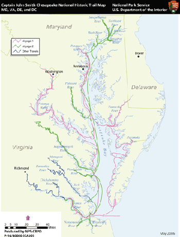
How do you manage a 3,000-mile-long historic trail that is largely water-based and touches three states? The folks running the Captain John Smith National Historic Trail are open to your suggestions.
Granted, the National Park Service has a few ideas on how to manage this large expanse of water and land that is woven through parts of Virginia, Maryland, Delaware, and even the District of Columbia. And they've come up with four alternatives. Now it's your turn to provide some feedback, to let the managers know if this is how you'd like to be able to enjoy and experience the country's first scenic water trail.
Wrapped around the Chesapeake Bay, the trail commemorates Captain Smith’s explorations of 1607-09. According to Park Service historians, "during those trips, Captain Smith mapped and documented nearly 3,000 miles of the bay and its rivers. Along the way he and his crew visited many thriving Native American communities and gathered information about this 'fruitful and delightsome land.' ... Smith’s map and writings influenced exploration and settlement of eastern North America for many generations, and they are a remarkable record of the native cultures and the natural environment of the 17th-century Chesapeake."
A year go the trail made the news when the Park Service announced an agreement with the National Oceanic and Atmospheric Administration to install a series of "talking buoys" that provide passing boaters not only with atmospheric and nautical information but also some pages out of history. The programmed buoys offer recordings that boaters, and even land-lubbers, can access via phone.
To give you a sense of this largely watery realm, check out this nearly 7-minute video:
While much already has been done in organizing this trail, now it's time to get serious with planning the long-range management. The four draft alternatives the Park Service has drawn up offer a range of recreational and educational programs. Three of the alternatives call for a mix of water trails and auto tour routes that would tie visitors into the historic trail. A fourth would tie visitors into that involvement without any specific trails or routes, but rather "recreational activities and volunteer environmental programs."
There also is a range of NPS involvement when it comes to protecting resources found along the trail. One alternative would focuse that protection "on significant voyage landing sites that provide public access to the trail," while another would leave protection up to local and state agencies. To see all the alternatives, read the attached pdf file.
A number of workshops are being held this month in Maryland, Virginia and the District of Columbia to go over these alternatives and take public comments. Here's the schedule:
October 13, 2009
Deltaville Community Center
17147 General Puller Highway
Deltaville, VA 23403
6 p.m – 8 p.m.
October 14, 2009
Annapolis Maritime Museum
723 Second Street
Annapolis, MD 21403
6 p.m – 8 p.m.
October 15, 2009
Charles Sumner School
1201 17th Street, NW
Washington, DC 20036
6 p.m – 8 p.m.
Via MetroRail: Farragut North (Red Line)
October 19, 2009
Barrier Islands Center
7295 Young Street
Machipongo, VA 23405
6 p.m – 8 p.m.
October 20, 2009
Seaford City Hall
414 High Street
Seaford, DE 19973
6 p.m – 8 p.m.
October 21, 2009
Chesapeake Bay Maritime Museum
Steamboat Building
213 North Talbot Street
St. Michaels, MD 21663
6 p.m – 8 p.m.
October 22, 2009
Havre de Grace Maritime Museum
100 Lafayette Street
Havre de Grace, MD 21078
6 p.m – 8 p.m.


 Support Essential Coverage of Essential Places


